It would have been so easy to laze around this morning, but Cinder Cone was one of our primary objectives here. I put my coffee cup down and donned my hiking boots.
 |
| Cinder Cone with trail up the side. |
Cinder Cone is on the eastern side of the park about 20 miles from our campsite. On the way we stopped at a “scenic vista”. We pulled in there on a whim and are sure glad we did. It was an awesome view of Lassen Peak and of Mt. Shasta 85 miles to the north. On our way again after a few photos, we located the dirt road that led to Butte Lake and Campground inside the National Park. Our trailhead was just past the boat launch area.
This trail is relatively short--just over 2 miles one way. The first mile and a half is relatively flat. The going was somewhat difficult, however, because the foot bed was crushed cinder about the consistency of sand. I found it difficult and tiresome to walk on. On the way to the Cinder Cone we passed the Fantastic Lava Beds and got a glimpse of the Painted Dunes. This area has been very slow at revegetation and there are still very few trees surrounding this cone that erupted about 350 years ago.
 |
| Lave Beds |
As Cinder Cone came into view, and shortly thereafter, the trail up Cinder Cone, I wondered why I hadn’t stayed home with my coffee cup. The trip up was slow and labored. A “two steps forward and a step backward” sort of hike. We exchanged the sand-like cinder for some of a little larger caliber, but still very small, loose, and conducive to sliding. It may have been worse than the snow we hiked in yesterday. The trail was VERY steep. I started out by taking 10 steps, then resting for 5 count. I increased my steps by 5 until I was able to do 50 before the resting 5 count. Eventually, I reached the top. Gene managed to move along a little faster than I and got the first view of the top.
Cinder Cone has two rims--an inner and an outer rim. We hiked down to the inner rim to cross to the other side of the crater. There was a trail that went down into the center, but I could see it just fine from where I stood. No need to go down there.
 |
| Lassen Peak as seen from top of Cinder Cone |
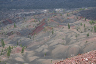
Hikers have the option of descending by the trail they came up or using the trail on the opposite side of the cone. We chose to go down this other trail which was, if anything, steeper than the one we came up and only about half as wide. We both fell once. I got to where I would just put my foot down and then ride out the slide. When I stopped, I’d take another step. We finally reached the bottom without major injury. By coming down this side, we had fantastic views of the painted dunes. We also had great views of Lassen Peak from the top.
 |
| Painted Dunes with lava beds in background |
This was a new experience for me and I am glad I went. But once is enough. I’m glad Mount St. Helens is still covered in snow. I wont be tempted.
Tomorrow morning we hit the road again. Our destination for tomorrow evening is Crater Lake. Oregon, at last.


No comments:
Post a Comment