Monday, April 30, 2012

Kephart Prong Trail


Friday we took a little hike up Kephart Prong Trail.  This is one of our favorite hikes in the Park.  The trail follows Kephart Prong as the name suggests and is named for Horace Kephart.


Kephart was born in Pennsylvania during the Civil War.  As an adult he had a career as a librarian working for a time at Yale University and as director of the St. Louis Mercantile Library.  While at the St. Louis Library he started writing and wrote about his hunting and camping trips.  He also wrote articles for Field and Stream and these articles were published as his first book, Camping and Woodcraft.  For folks of East Tennessee and Western North Carolina, he may be best known for Our Southern Highlanders--a description of his life in the Smoky Mountain area and the culture and lifestyle of the Appalachian Mountain region.


Sometime in his late 40s or early 50s Kephart moved to the Hazel Creek section of what is the National Park today.  In his own words he chose “the wildest part” of the area to settle.

Kephart was an enthusiastic promotor for the establishment of Great Smoky Mountains National Park.  He didn’t live long enough to see the Park dedicated, but knew that it would become a reality.

So, a trail, a creek, and a mountain inside the Park are named for this great man.

The trailhead is on the east side of Newfound Gap Road about halfway between Newfound Gap and the Oconaluftee Visitor Center.  There are two parking areas, one on each side of the road, which will accommodate several cars.  As the trail begins, it immediately crosses the Oconaluftee River.  The trail follows Kephart Prong as it gradually ascends about 700 feet in elevation to Kephart Shelter at the end of the trail in just two short miles.


The trail switches back and forth from one side of Kephart Prong to the other four times before reaching the shelter; each time on a footbridge.  The trail is wide and at one time was paved.  Along our walk we could still see the occasional remnants of asphalt.

CCC Sign.  Nothing can be read on the sign now.
Shortly after we got started we came to what’s left of an old CCC camp.  The CCC did a lot of work in the early days of the Park.  This particular camp was occupied during most of the 1930s and very early 40s.  About all that’s left today is the camp sign, an old water fountain, and a couple chimneys.


The water fountain looks pretty good.  Of course, it doesn't work.
We saw discarded car and truck parts as we walked along.  Stuff like this can be seen along trails throughout the park.  You probably could collect enough pieces to build a car; not sure how well it’d run.  Along the Appalachian Trail there are even aircraft parts from an airplane crash long ago.


The real drawing card for this hike is Kephart Prong.  It is gorgeous as it makes its way to merge with the Oconaluftee River.  Wildflowers are also good along the edge of the trail, but the elevation is low enough that they are past their prime now.  We did see brook lettuce and speckled wood lily.

Speckled Wood Lily


This shelter has been renovated recently.  Smoky Mountain Hiking Club have done a tremendous job of renovating all (I think) of the backcountry shelters in the park.  Kephart shelter, like all the others, has had the fencing removed from the front, bear cables installed, skylights added, benches and a cooking porch added to the front.  This shelter also has a fireplace inside which is a nice feature on chilly nights.  For us, it was a great place for a break.


We continued on past Kephart Shelter, but I’ll get to the rest of the story in a later post.

That’s it for today.  Thanks for tagging along.

Saturday, April 28, 2012

Cherokee, North Carolina


Cherokee is the gateway town to Great Smoky Mountain National Park in North Carolina.  Cherokee is within the Qualla Reservation and is home of the Eastern Band of the Cherokee Indians.


Tribal leaders, in an effort to pass on the Cherokee heritage to the younger generations, label street signs and many buildings both in English and the Cherokee language.


Like many Indian Reservations, Cherokee has a casino which is a popular place for many visitors to the community.  Profits are passed on to the members of the tribe.  It is probably the largest employer in town, as well.

Being a gateway community, naturally much of the revenue comes from tourism.  Driving through town creates a mix of emotions.  There are many of the old motels from the 50s; most have been renovated but some haven’t and are essentially an eyesore.  Also left over from decades ago are the “attractions”--live bears and live Indians.  Much of the Indian stuff seems to cater to our mental image of the Native American--a plains Indian in long feathered headdress, teepees, and bison.  The Cherokee really weren’t like that and I don’t get why they depict themselves as such.  Money, I suppose.


There is a “tourist” section off the main highway with the tee-shirt and souvenir shops and, of course, ice cream and fudge.  There is also a Cherokee museum.  We haven’t been in there, but the building and grounds look nice from the outside.  There is also a gallery for local artists to sell their handmade crafts and works of art.  We were in there a couple years ago and there are some truly beautiful pieces.

One of the greatest accomplishments of the Cherokee was the development of a written language by Sequoyah.  One of the greatest tragedies of the Cherokee was their forced removal by Andrew Jackson.  The Cherokee who are here today are descendants of those few who were able to escape removal.

We’ve been driving into Cherokee every afternoon to check our phone messages, e-mail, and to post the blog.  Usually, we stop just inside the reservation at the Transit Center, but occasionally we’ll drive across town to the McDonalds.  We’ve only gone to the Dairy Queen once for ice cream after a hike.

That’s it for today.  Thanks for tagging along.

Friday, April 27, 2012

Chasteen Creek Trail


This is another hike from the Smokemont Campground and the trailhead is at the back of the campground.  To get to Chasteen Creek Trail we had to follow Bradley Fork Trail a little over a mile to the trail junction.  Not only does Chasteen Creek Trail junction with Bradley Fork Trail at this point, but Chasteen Creek enters Bradley Fork at this point also.  Luckily, there is a very fine footbridge here, for which we are always grateful.

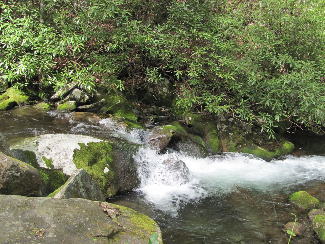
Chasteen Creek as it rushes toward Bradley Fork
It had rained almost the entire night before we did this hike and had only just stopped raining when we were ready to get started.  This was a long hike (11.2 miles round trip), but with a relatively gentle climb at the beginning, saving most of the elevation gain for the last mile and a half.

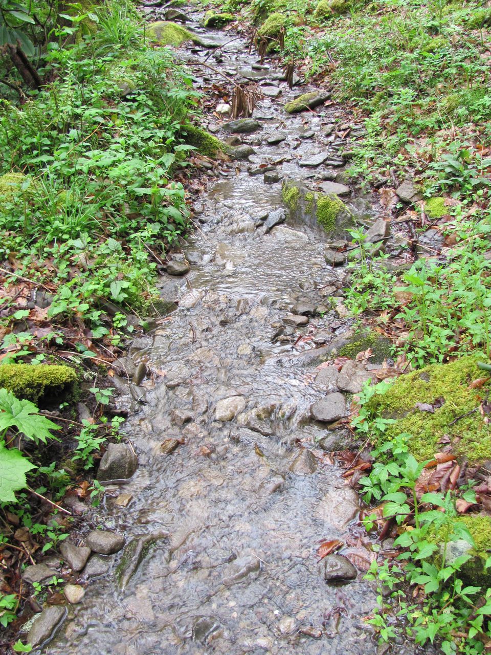
The guidebook describes Chasteen Creek Trail as notorious for being muddy from poor drainage and heavy horse use.  Given the rain from the night before, we figured we were in for a real treat.  We were pleasantly surprised and again grateful to find the first mile of the trail had been repaired and graveled.  No mud, not even water for that matter, anywhere on that section of trail.

Past this first mile, which is a very gentle grade, the trail becomes noticeably steeper, but not so bad.  It is at this point still an old roadbed--very wide.  It gets a lot of horse use, but drains better up here so we didn’t have muddy spots.

Larkspur
A little past half way along the trail, we came to backcountry campsite 48.  From the trail we could see there were a couple tents pitched near the creek so we stopped for our break on the trail rather than disturb those folks.

Found another pink lady slipper today
Beyond the campsite, the trail narrowed and almost immediately become steeper for its final push to Hughes Ridge.  About the first half mile of this section was very rocky.  I understand that the rocks help hold the dirt in place, especially on horse trails, and help to keep erosion at bay, but they sure are murder on a hikers feet.


Past the rocks the trail surface became dirt, which was a real pleasure to walk on.  This last mile seemed to go on forever.  At every switchback, I’d think we were there, only to see the trail bend around yet another corner.


Finally, we walked through a short rhododendron tunnel and popped out the other side at the junction with Hughes Ridge.  Unfortunately, this was not where we thought we’d be and we were dismayed to read the sign telling us that Enloe Creek Trail junction was still a half mile away.

Hughes Ridge junction offered several logs for sitting, so we sat down for lunch while we contemplated going that extra mile round trip to Enloe Creek.  After a nice break, we felt better and decided that it’d be better to do it now than later.  Even though the trail led uphill, it was an easy climb and we were at the Enloe Creek junction in no time.  We touched the sign and headed back from whence we’d come.


None of the trails in the  Smokies are blazed except the Appalachain
That was the hike so now for the side stories.  Some hikes have their moments.  We had a couple today.

First, a word about Chasteen Creek Trail.  This trail, together with several others within the National Park, is part of the Benton MacKaye Trail, a long distance trail which begins in north Georgia at Springer Mountain and runs almost 300 miles to Davenport Gap in the Smokies.  The trail enters the Smokies at Twentymile Ranger station on the southwest side of the park and ends at Dig Creek campground on the northeast side.

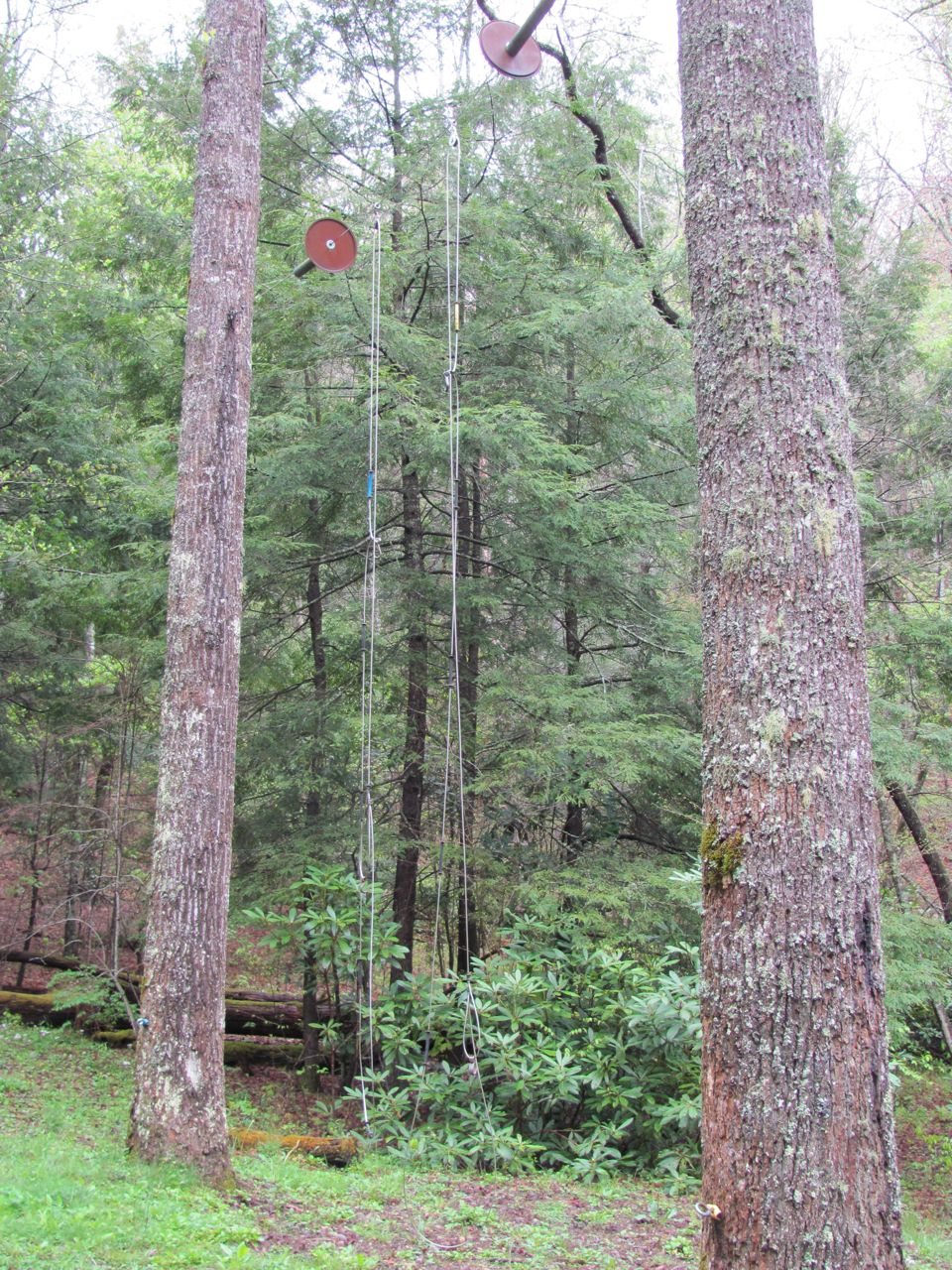
I mentioned that we saw tents pitched at backcountry campsite 48.  It looked like a real encampment down there with a couple of tents and a couple of tarps pitched so the hikers could get out of the rain to cook.  There were also lines strung from trees which were being used to dry clothes.  In the Smokies, those clothes still won’t be dry a week from Tuesday; it’s just too humid.  We saw just one person down there sitting on a log reading or writing or something.  After our break, we continued on our way up hill.  We were making pretty good progress when, all of a sudden out of nowhere, a man appeared heading downhill.  It’s certainly not strange to see hikers on trails, but this guy just didn’t have the look.  For one thing, it was pretty early to be coming down from that high up.  For another, he didn’t have a pack; just a water bottle stuffed in his shorts pocket.  He seemed friendly enough, though.  We chatted a few minutes.  Actually, Gene chatted, I was really looking the guy over and listening intently to every word trying to decide if we were in danger.  He seemed to be the hiking partner of the other guy we’d seen down in the camp.  The things he said seemed to all fit the circumstances, but I was leery when he said he and his partner had been camped there for 3 days.  The guy seemed to be too clean and freshly shaven for that length of time and that made me even more suspicious.

We parted ways and for the rest of our ascent to Hughes Ridge I kept thinking about the two hikers who became missing in the park several weeks ago, wondering if there was any connection between these guys and them.  As far as I know, they’ve never been found.  I worried and stewed over that, but pretty much forgot about it during lunch.

After lunch we headed up Hughes Ridge to Enloe Creek junction.  As we approached the junction we saw a horseman coming up Enloe Creek Trail.  This guy was very friendly and immediately struck up a conversation, as he took up his position right in the middle of the junction and wasn’t going to move that horse for anything.  As he sat atop his steed he soon came to the point of his conversation.  He was there to lead us to his best friend, Jesus.  Gene dubbed him the “prophet of Enloe Creek”.  We finally escaped his sermon, but not until he’d asked, “if you die today, where will you spend eternity?”  Don’t get me wrong--I admire the man for his conviction and courage to share the Good News with any old hiker he meets on the trail.  However, I had 6 miles to go to get down from that place on high.  I’d been standing up for 5 hours and had several more steps to take before my journey was over.  I wasn’t much in the mood for a sermon.  Besides, that “if you die today” question made me worry all over again about those two fellows at campsite 48.  His parting words were of love.  He assured me that Jesus loved me and he loved me, too.  Well, I have no doubt that Jesus loves me, but I’m not as assured of his love.  If he truly loved me, he’d give me a ride on that horse back down the hill.

That’s it for today.  Thanks for tagging along.

Thursday, April 26, 2012

Down on the Farm


After our hike on Monday, we took life easy on Tuesday.  There are always a few chores to do, books to read, knitting, and sudoku puzzles.  We did a little of all of that during the morning and after lunch went for a drive about town.  On our way home we stopped at the Oconaluftee Visitor Center to check out the Mountain Farm Museum.

There are several structures which make up the “farm”; all of which are original to the park though they may have been moved to Oconaluftee from other areas.

Naturally, located at the front is the home place.  We noticed smoke coming from the chimney so we stopped in to see what was happening.  We were a little too late for the lunch meal.  The ladies in the kitchen, dressed in period costume were just cleaning up from whatever they’d prepared.


Of course, every farm had this essential structure--the outhouse.


The apple house, which was originally in Cataloochee Valley, is the only building on the farm not made entirely of wood.


The barn brought back a lot of memories for me.  It is very similar to the one my grandfather had.  My brother, cousins, and I whiled away a lot of afternoons in that barn.

There are a couple large gardens on the farm.  Both had been tilled, but it didn’t look like anything had been planted yet.  It’s not past the frost date in this part of the country yet.  In fact, the southern end of the Blue Ridge Parkway is closed for snow today.

As we went past the corn crib, this little fellow came running around the corner.  The corn crib may have been his home.  He didn’t look like he’d missed many meals.


Our visit to the farm brought back some fond memories of my childhood when I’d visit my grandparents for much of the summer.  It is all very nostalgic and somewhat romantic to think of being self sufficient--raising and growing your own food, sitting by the fireplace in the evening working on the latest quilt, picking apples from your own trees, gathering fresh eggs.  Some call these the “good ole days” when life was simpler without the fast-paced rat race we sometimes get caught up in nowadays.  Those days are nice to remember, but I think I’m happier with my rat race--especially since it’s no longer at the office.


By the way, we are once again camped inside the National Park and do not have cell service.  Posting may be sporadic depending on our trips into Cherokee.

That’s all for now.  Thanks for tagging along.

Tuesday, April 24, 2012

Cabin Flats Trail


For our first hike in the Oconaluftee area, we chose Cabin Flats Trail.  This is a sweet little 1.1 mile one way trail that goes up to backcountry campsite 49 on the banks of Bradley Creek.  The real problem with Cabin Flats Trail is that the trailhead is 4 miles from the road.  So our sweet little out and back hike ended up being 9.2 miles.
Found this showy orchis among the phlox and geranium
Our hike began on Bradley Fork Trail at the back of the Smokemont campground.  It’s early in the season and this campground is not fully open yet.  There is a small parking area for hikers near the trailhead, but that loop is still closed.  We had to walk several minutes to get to the trailhead.  When that loop is open, not only is there parking, there is also a restroom nearby.
Bradley Fork Trail
Bradley Fork Trail is a delight.  It is a wide gravel road which follows Bradley Fork all the way to Cabin Flats Trail.  This is a popular fishing area and there are numerous paths from the main trail down to the creek.  There are also several benches along the trail.  We utilized one of these benches for our lunch spot.
A side creek
Bradley Fork Trail is open for horse use so you have to watch your step, but the trail is in good condition without a lot of mud holes.  In fact, some of the worst spots had been recently repaired with what looked like several loads of gravel.

The bridge on Smokemont Loop Trail is still broken in the middle
Perhaps the best part about Bradley Fork Trail besides its scenic beauty, is that it is almost flat.  At least as flat as any trail gets in the Smokies.  Over the first 4 miles, it only gains about 800 feet.


Our hike crossed Bradley Fork and a couple of side creeks, but all crossings were on foot bridges.  One was on an impressive trestle bridge.  This area escaped the logging industry and the bridge seemed too narrow even for old cars.  We’re not sure what the bridge was originally used for.
Unnamed Falls
At the trail junction for Cabin Flats Trail, Bradley Fork Trail veers off sharply to the right and begins it ascent to Hughes Ridge.  Glad I wasn’t hiking up there today.  We continued straight and almost immediately stepped on to the trestle bridge crossing Bradley Fork and continued our hike on the opposite bank.

Cabin Flats Trail isn’t quite as flat as Bradley Fork, but almost with only a slight rise before dropping back down to creek level again at campsite 49.  The trail ends here at this beautiful campsite next to the creek nestled in amongst the rhododendron.


This was a great place for our coffee break.  Well, Gene had coffee; I had hot chocolate. Anything hot would do--I was freezing to death.  It was a cold, blustery morning and we hadn’t been on the trail very many minutes before it started to sleet.  That lasted for an hour or so then it started to snow.  We had sleet or snow all the way to campsite 49.  While we sat on a log drinking our hot beverage, the sun finally started to peek out through a few holes in the clouds.
Yes, that's snow on the rhododendron
We retraced our steps for the return trip stopping at one of those benches on Bradley Fork Trail for a lunch break.
Unnamed falls
It was a beautiful hike with all that rushing water.  We even saw a couple unnamed water falls; actually they were more like cascades.  There were still a few spring wildflower out--mostly phlox, wild geranium, and a few iris.  We saw some trillium, but it was beyond the flowering stage.  I just wish it had been a little bit warmer and less windy.

That’s all for today.  Thanks for tagging along.

Monday, April 23, 2012

Cataloochee Valley to Oconaluftee


We’ve moved on from our spot at Creekwood Farm RV Park.  We had some fine hikes out of Cataloochee Valley.  I’m glad to say all the trails on my map are colored in for this area except for Swallow Fork which I can get to either from Big Creek or Cosby so will wait until later in the summer to do that.  That’s probably going to require a backpack anyway and we’re just not up to that level of fitness yet.

In a way I’m gonna miss hiking in Cataloochee.  For one thing, that is where the elk are so we probably won’t see them anymore.  They’re moving closer to Oconaluftee and they say you can see them there, but I never have.  Also, Cataloochee is in a remote section of the park and gets much fewer visitors that other areas.  It was nice not fighting the crowds and not having the heavy traffic.  Best of all, I love the drive through the valley to the trailheads.

The one thing I will not miss is the drive down Cove Creek Road to get to the valley. This narrow, twisty, gravel road is not a pleasant ride, despite its historical significance.  The road is roughly the same route used by the Cherokee to access the settlements around Cosby, Tennessee.  It was also the route used by Bishop Francis Asbury as he cross the mountains in the early 1800s.

Now, we’re in the Cherokee, North Carolina area.  The Oconaluftee entrance to the Park is the main entrance on the North Carolina side on US 441.  The Oconaluftee Visitor Center has the usual visitor information area with rangers and volunteers on hand to answer questions and give directions.  There is, of course, a gift shop and a backcountry ranger office.  This is a brand new visitor center which opened only a year ago.  There are impressive exhibits in the museum area which recount the history of life in the mountains.


Adjacent to the new Visitor Center is the Mountain Farm Museum.  This is like a working farm with several old buildings which have been moved to this location from other areas of the park.  The apple house was moved from the Cataloochee Valley.  Periodically, volunteer re-enactors dressed in period costume are out on the “farm” giving demonstrations of how life used to be.  
Mountain Farm Museum
We’ll be over here for several days hiking trails which lead off Newfound Gap Road, Clingman’s Dome Road, and from the Smokemont area.

That’s it for today.  Thanks for tagging along.

Saturday, April 21, 2012

A Drive Along The Blue Ridge


After that all day hiking event on Thursday, we weren’t too eager for another hike, but didn’t want to just sit around the house and then be stuck inside because of rain over the weekend.  Gene had picked out what he thought might be a little leg stretcher.  He found a short 5-mile loop hike with a 3-mile option if we didn’t want to go the whole distance.  As it turned out, I didn’t even take the first step.  He did better than I, but turned around after about a quarter mile.  Guess we were more tired than we thought.


To get to that hike we had to go over to the Blue Ridge Parkway.  After finding the trailhead, we spent a few minutes looking around at the little park there before finally deciding we really weren’t up to hiking after all.  What to do now?  We had driven all the way over there (along US 276 through beautiful rural North Carolina which wasn’t a waste of time by any means) and we had most of the day left with no plans or commitments.  A drive along the Blue Ridge Parkway seemed like a worthy option.


The Blue Ridge Parkway is part of the National Park Service designated a National Scenic Byway.  This two-lane road runs primarily along the crest of the Blue Ridge of the Appalachian Mountains for 469 miles between the southern end of Shenandoah National Park in Virginia and the Oconaluftee entrance to Great Smoky Mountain National Park in North Carolina.  There are many pullouts at scenic overlooks.  The park service also maintains several historical structures along the parkway.  Stopping at the overlooks and at every historical exhibit can be very time consuming.  Driving the Blue Ridge would be like driving Skyline Drive in Shenandoah or the Natchez Trace Parkway.    Exploring every nook and cranny could take days.


Since that trail we were going to hike was only three miles south of Pisgah Inn we decided to let that be our starting point for our 40 mile drive south to the exit for Wayneville.  The Parkway, being on the ridge, is at high elevation.  We were above 5,000 feet for our entire drive and in the clouds.  Along this 40-mile stretch we drove over the highest point on the entire Parkway at 6,053 feet.  The fog was so thick at times we could hardly see the lines on the road.  Later in the day, the sun was able to do its thing and we had occasional views.


We enjoyed the drive and since there are several great hiking destinations along the Blue Ridge, we’ll be back.

We want to give a big welcome to our latest follower, Becca.  Becca is also a hiker and a bicyclists, and a lover of the outdoors. Welcome and thanks for tagging along, Becca.

That’s it for today.  Thanks for tagging along.

Thursday, April 19, 2012

Pretty Hollow Gap Trail

After a couple days of rain and sitting around the house, we were anxious to get outside.  The one trail left in the Cataloochee Valley that I wanted to do before we leave the area is Pretty Hollow Gap.

Lots of water in Pretty Hollow Creek
This is a 5.6-mile one way trail which rises from the valley to Mount Sterling Ridge.  Our parking lot was a short quarter-mile from the large Cataloochee horse camp.


The first 1.6 miles of the trail is the same as we did last week when we hiked the Palmer Creek Trail.  The trail is along an old road bed as it follows Pretty Hollow Creek upstream.  At 0.8 miles we passed the Little Cataloochee Trail junction and at 1.6 miles we passed the Palmer Creek Trail.
Horse corrals at campsite 39
Shortly past the junction with Palmer Creek we came to backcountry campsite 39.  Since Pretty Hollow Creek Trail allows horses this campsite has horse corrals installed for those overnight guests.  There are also a couple of pulley systems for hanging food out of the reach of critters.  These pulley systems are at all backcountry campsites and shelters in the Smokies.
Backcountry pulley system
After this, the trail narrows and begins the climb to the ridge.  We followed Pretty Hollow Creek upstream for about 4 miles with four crossings.  Two of these crossings were on foot bridges and two were on the rocks.  There were also areas of the trail that were pretty wet.  We were sorta wishing it hadn’t been raining for the past 24 hours.
Water running down the trail
After the last crossing we turned away from the creek and pushed on up to the Gap.  We started our hike in hardwood forest and, as we gained in elevation, we passed through rhododendron, pine, and what’s left of the hemlock.  Near the top the forest changed to spruce and fir.  Not only did the forest change, but as we gained elevation we started seeing the early spring wildflowers again.
Finally, the Gap


Pretty Hollow Gap was a welcome sight after that climb.  The gap was like a busy intersection where three trails come together.  We found a log to sit on and took a long lunch break.

We retraced our steps for our trip back down to the car.  I think I was happier to see the car than to get to the Gap.

That’s it for today.  Thanks for tagging along.