I have been in the “mulligrubs” today. I guess the tiredness is catching up. All I’ve wanted to do today is sit. I did manage to get the laundry done and the ironing. I got my food in order for my next backpacking trip. Also cut Gene’s hair this afternoon. But everything has seemed so hard to do and I just don’t seem to have the energy for it.
I have outlined six more days of hiking for the time we have left here—three day hikes and a 3-day backpacking trip. That will give me 160 miles of new trail for this section. I’m happy with that.
I am struggling to keep my goal in focus. In all my years of hiking, I have seldom gone alone. I have never gone backpacking alone, and I will have to say I don’t much like it. I have not been afraid, although I was a bit nervous when I saw so many signs of bear. I think what really bothers me is the loneliness. It is becoming increasingly more difficult to go out each morning. Thankfully, tomorrow and Sunday Gene will be able to go with me. Rather, I should say, he will be out there on the trail. He will drop me off at my starting point and take the truck to the end point then hike toward me. When we meet somewhere in the middle, he will retrace his steps so I will have a companion for the last half of my hike.
I do not live by hiking. There are other things I enjoy doing. I am beginning to miss trying new recipes and cooking. I took several photography classes at Life on Wheels and I am anxious to practice. There are several attractions in this area I would like to visit. I also enjoy bicycling and haven’t been riding since February. I guess all these things are playing on my mind today and have gotten my spirits down.
I guess you are probably pretty tired of hearing me whine. Perhaps I’ll just go get my pack ready for tomorrows hike.
In the words of my good friend, Herb—“keep moving forward”. Good advice.
Saturday, May 31, 2008
Friday, May 30, 2008
A One Night Backpacking Trip
It was a short little trip, but the views were outstanding, the trail was good, and Loft Mountain Campground has hot water.
I started Wednesday morning in a slight mist from Blackrock Gap. I was a little apprehensive since this was my first time to backpack alone. I feel more comfortable here than most places because the trail sticks pretty close to the road. If I had trouble, it would only be a short walk to the road and we have discovered in the past couple weeks that we usually have a cell signal most places along Skyline Drive. All that is very comforting, but to walk away from my husband in the early morning was a bit disconcerting.
But the trail soon took my mind off that as it went right up to the summit of Blackrock Mountain. It was a big pile of rock on the summit and looked like a rock slide going down the side of the mountain. I don’t think there is anything else like it in this area.
My destination for the day was Loft Mountain Campground. I found a site and set up house for the night. I got there early in the afternoon—plenty of time to take a little nap. I was very impressed with the Campground. There were about 200 sites and, as is often typical of national park campgrounds, the sites were huge. I found a site near both the restroom and the trail.
The restroom was special—it had hot water. Most national parks don’t so this was a real treat. I had planned on burning off most of my stove fuel by heating water for a bath.
I’ll have to say I was lonely by myself. I read every word on my map (more than once) and did every sudoku puzzle I had. I was surprised to see Jack rabbits, but they were very entertaining. I was also surprised not to see deer. I was relieved not to see a bear (and also grateful).
Thursday, I was up early and getting ready to go. Gene was picking me up at Simmons Gap at 2 PM. It was just 9 miles away, but over several climbs. I wanted to have plenty of time. It was a glorious sunny morning and the views were fantastic.
After getting away from the campground area the trail stayed in the forest away from the road for several miles. I got nervous when I saw so much bear scat and then started to see overturned rocks. Bear signs for sure. I was forced to sing the 99 bears on a wall song to protect myself. Surely no self-respecting bear would get close to that noise.
I was early to Simmons Gap, but it gave me a chance to get started resting. It was a good hike. The trail was well groomed most of the way with no big rocks to climb over, the mountain laurel was just starting to bloom, and the birds were singing. Who could ask for more?
 |
| Black Rock Mountain |
I started Wednesday morning in a slight mist from Blackrock Gap. I was a little apprehensive since this was my first time to backpack alone. I feel more comfortable here than most places because the trail sticks pretty close to the road. If I had trouble, it would only be a short walk to the road and we have discovered in the past couple weeks that we usually have a cell signal most places along Skyline Drive. All that is very comforting, but to walk away from my husband in the early morning was a bit disconcerting.
 |
| Clouds over the valley |
But the trail soon took my mind off that as it went right up to the summit of Blackrock Mountain. It was a big pile of rock on the summit and looked like a rock slide going down the side of the mountain. I don’t think there is anything else like it in this area.
 |
| Mountain Laurel |
My destination for the day was Loft Mountain Campground. I found a site and set up house for the night. I got there early in the afternoon—plenty of time to take a little nap. I was very impressed with the Campground. There were about 200 sites and, as is often typical of national park campgrounds, the sites were huge. I found a site near both the restroom and the trail.
 |
| Skyline Drive below the AT |
The restroom was special—it had hot water. Most national parks don’t so this was a real treat. I had planned on burning off most of my stove fuel by heating water for a bath.
 |
| View from Loft Mountain |
I’ll have to say I was lonely by myself. I read every word on my map (more than once) and did every sudoku puzzle I had. I was surprised to see Jack rabbits, but they were very entertaining. I was also surprised not to see deer. I was relieved not to see a bear (and also grateful).
 |
| Ivy Creek |
After getting away from the campground area the trail stayed in the forest away from the road for several miles. I got nervous when I saw so much bear scat and then started to see overturned rocks. Bear signs for sure. I was forced to sing the 99 bears on a wall song to protect myself. Surely no self-respecting bear would get close to that noise.
I was early to Simmons Gap, but it gave me a chance to get started resting. It was a good hike. The trail was well groomed most of the way with no big rocks to climb over, the mountain laurel was just starting to bloom, and the birds were singing. Who could ask for more?
 |
| My ride!! |
Wednesday, May 28, 2008
Follow the White Blaze
Having reached Rockfish Gap on our hike Monday, I have completed right at 100 miles of AT in the past 2 weeks. D-Tour and I did about 70 miles, I have done 2 day hikes in Shenandoah National Park and 20 miles between VA 664 and Rockfish Gap. Now I am concentrating on the 100 miles in Shenandoah. Tomorrow morning Gene will take me up to Skyline Drive for a 1 night backpacking hike. I am following that white blaze and connecting point to point.

Speaking of white blazes, that is how we hikers know where to go. The 2100+ miles of the AT are blazed every few feet with a roughly 2 x 6 inch white blaze. It is like reading street signs and traffic directions. A single white blaze marks the trail. A double white blaze indicates a place where the hiker should be cautious to stay on the trail, usually because of a turn. Sometimes the top blaze of a double blaze may be slightly to the right or left of the lower blaze. This indicates the direction of the turn. Blue blazed trails lead to shelters, water sources, or points of interest.

To help you know exactly where you are along the trail, there are maps and guidebooks. The most popular books are the Thru-Hiker’s Companion, Appalachian Trail Data Book, and the Appalachian Trail Guide Books. The Thru-Hiker’s Companion and Data Book are all inclusive in one small book giving the hiker the bear essential information about the location of shelters, water, roads, groceries, lodging, campgrounds, and towns. The Guide Books are many—one guide book for about every 100-200 miles of trail. These books are much more comprehensive than the other two and include some local history, descriptions of side trails, and more details of the AT. I use the Guide Books most often. The maps include a trail profile. Although I spend a great deal of time looking at the profile, practically memorizing how many up hills there are, when I’m actually hiking it seems to be all up hill. The maps are waterproof and now are GPS compatible.
Today I took a zero day. I stayed home and did chores—laundry, grocery, vacuuming, etc. I fixed a couple things for Gene to have to eat while I’m gone, including a pineapple upside down cake. I can’t remember the last one of those I had. I have enjoyed the day. I really am a home-body. I like to just piddle around the house. It has been fun and a nice break from hiking. But the white blaze is calling my name and I’ve got to get back out there.

Speaking of white blazes, that is how we hikers know where to go. The 2100+ miles of the AT are blazed every few feet with a roughly 2 x 6 inch white blaze. It is like reading street signs and traffic directions. A single white blaze marks the trail. A double white blaze indicates a place where the hiker should be cautious to stay on the trail, usually because of a turn. Sometimes the top blaze of a double blaze may be slightly to the right or left of the lower blaze. This indicates the direction of the turn. Blue blazed trails lead to shelters, water sources, or points of interest.

To help you know exactly where you are along the trail, there are maps and guidebooks. The most popular books are the Thru-Hiker’s Companion, Appalachian Trail Data Book, and the Appalachian Trail Guide Books. The Thru-Hiker’s Companion and Data Book are all inclusive in one small book giving the hiker the bear essential information about the location of shelters, water, roads, groceries, lodging, campgrounds, and towns. The Guide Books are many—one guide book for about every 100-200 miles of trail. These books are much more comprehensive than the other two and include some local history, descriptions of side trails, and more details of the AT. I use the Guide Books most often. The maps include a trail profile. Although I spend a great deal of time looking at the profile, practically memorizing how many up hills there are, when I’m actually hiking it seems to be all up hill. The maps are waterproof and now are GPS compatible.
 |
| Sometimes that white blaze goes where I'd rather not go. |
Today I took a zero day. I stayed home and did chores—laundry, grocery, vacuuming, etc. I fixed a couple things for Gene to have to eat while I’m gone, including a pineapple upside down cake. I can’t remember the last one of those I had. I have enjoyed the day. I really am a home-body. I like to just piddle around the house. It has been fun and a nice break from hiking. But the white blaze is calling my name and I’ve got to get back out there.
Tuesday, May 27, 2008
On To Rockfish Gap
Our hike yesterday took us from the Humpback Rocks parking area to Rockfish Gap. What a wonderful section of trail. It was very well maintained, even having been recently weed-eated. It was a rare treat along the AT in this area to hike on dirt rather than pick our way over rock. The up and down hill areas were well graded with rock steps at the switchbacks.
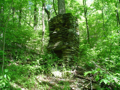
The Paul C. Wolfe Shelter is a work of art. Sitting above Mill Creek, it boasted a large cooking porch with a picnic table. The sleeping platform was almost spotless. I had a fleeting thought that it had been vacuumed and dusted. I guess not, but it was very clean. I do not have any personal experience with the privy at this shelter, but I did read in the shelter register that it was outstanding. Mill Creek offers a swimming hole and waterfall for weary, dirty hikers. Our hats go off to the Old Dominion Appalachian Trail Club that maintains this section. Great job, guys.
We passed the remains of an old chimney just off the trail. Sometimes it is hard to imagine anything ever being here other than forest, but the trail passes through many areas which were thriving communities in the past. Most of these places have long since returned to a wilderness area.
Since we were near the Humpback Rocks Visitor Center, after our hike we stopped by to tour the Mountain Farm. It is a reconstruction of an early European pioneer farm in the area. The 19th century farm buildings are open for investigation and there were volunteers dressed in period clothing as well as a park ranger to answer questions and demonstrate pioneer skills. There were onions coming up in the garden and chickens in the chicken coop.
 |
| Farm equipment along the trial |
The Paul C. Wolfe Shelter is a work of art. Sitting above Mill Creek, it boasted a large cooking porch with a picnic table. The sleeping platform was almost spotless. I had a fleeting thought that it had been vacuumed and dusted. I guess not, but it was very clean. I do not have any personal experience with the privy at this shelter, but I did read in the shelter register that it was outstanding. Mill Creek offers a swimming hole and waterfall for weary, dirty hikers. Our hats go off to the Old Dominion Appalachian Trail Club that maintains this section. Great job, guys.
 |
| Cooking porch at Paul Wolfe Shelter |
We passed the remains of an old chimney just off the trail. Sometimes it is hard to imagine anything ever being here other than forest, but the trail passes through many areas which were thriving communities in the past. Most of these places have long since returned to a wilderness area.

Since we were near the Humpback Rocks Visitor Center, after our hike we stopped by to tour the Mountain Farm. It is a reconstruction of an early European pioneer farm in the area. The 19th century farm buildings are open for investigation and there were volunteers dressed in period clothing as well as a park ranger to answer questions and demonstrate pioneer skills. There were onions coming up in the garden and chickens in the chicken coop.
 |
| Log Cabin at Mountain Farm |
 |
| Root Cellar |
Pacific Crest Trail
There are several popular long-distance hiking trails in our country. Perhaps the most popular is the Appalachian Trail, but there are two other trails which draw the attention of the long-distance hiker. The “triple crown” in hiking trails is the AT (Appalachian Trail), the CDT (Continental Divide Trail), and the PCT (Pacific Crest Trail).
The PCT follows the Sierra Nevada and Cascade Mountains through California, Oregon, and Washington from the Mexican border to Canada, a distance of over 2600 miles. Since we are going to be in California, Oregon, and Washington for the rest of the summer, we will have the opportunity to hike on other sections of this trail during our travels.

We have done several hikes along the Tahoe Rim Trail which winds its way around Lake Tahoe. In order to make that loop, the Tahoe Rim Trail uses the PCT on the western side of the lake. Technically, we were on both trails for our hike today.
We drove US 50 through South Lake Tahoe, up to Echo Summit, then dropped slightly to the Echo Lakes. Echo Chalet is a lakeside mountain resort operated by the Forest Service. The cabins are not open yet for the season, but both lakes are free of ice. We parked in the upper parking lot and started our hike by crossing the dam at the end of the lake.
The trail quickly rises about 50 feet above the lake and then levels out for a very nice walk, with fabulous views of the lake. For our hike, we started at the southern end of the lower lake and hiked to the northern end of the upper lake, a distance of about 3 miles one way. During the summer season, Echo Chalet runs a water taxi servicing the entire length of both lakes. No taxi today so we had to walk back.
At the northern end of the lower lake and all along the upper lake, are very nice summer homes. I don’t know what the story is there--if they are rented from the forest service, if they are privately owned on private property, or if the owners have leases from the government. The only access to these homes is by boat or by trail; there are no roads in the area.
There is still quite a lot of snow on the other side of the lake, but on the south facing slope where we were, most of the snow has melted. There were a few spots in the trees that were still snowy and there was a lot of water on the trail from run-off at the upper lake.
It was a beautiful day and a glorious place to hike. I always enjoy the scenery, and I was not disappointed today. My favorite part, I think, was sitting on the end of the water taxi dock enjoying the sunshine, the spectacular view, and lunch.
 |
| Our starting point |
 |
| The larger lower lake |
 |
| Views from the trail |

We have done several hikes along the Tahoe Rim Trail which winds its way around Lake Tahoe. In order to make that loop, the Tahoe Rim Trail uses the PCT on the western side of the lake. Technically, we were on both trails for our hike today.
 |
| The smaller upper lake |
 |
| The northern end of the upper lake |
 |
| roots, ruts, rocks, and run-off on the trail |
At the northern end of the lower lake and all along the upper lake, are very nice summer homes. I don’t know what the story is there--if they are rented from the forest service, if they are privately owned on private property, or if the owners have leases from the government. The only access to these homes is by boat or by trail; there are no roads in the area.
 |
| Gene on the end of the boat taxi dock |
It was a beautiful day and a glorious place to hike. I always enjoy the scenery, and I was not disappointed today. My favorite part, I think, was sitting on the end of the water taxi dock enjoying the sunshine, the spectacular view, and lunch.
Monday, May 26, 2008
Memorial Day
It’s a holiday weekend and our campground is packed. It is full of mostly Grandpa and Grandma--local folks who brought their RVs out for the long weekend. After they got set up the children came and the grandchildren. From the number of cars parked along the street and all over the grass, most of the neighbors came, too. But it is alright. Everybody is having a fun time. Campfires dot the landscape and there is the smell of wood smoke in the air. The families are playing volley ball, shooting baskets, and throwing horse shoes. There is always a crowd of grandparents sitting in lawn chairs around the playground. The campground owners just filled the swimming pool here on Thursday. The water must still be about 55 degrees, but that doesn’t stop the kids. They’re loving it. It makes me feel good that families are getting in a little quality time together.
I suppose for the majority of us, this is the essence of Memorial Day—a three day weekend to spend with family. That is great, but Memorial Day is also something else—a time for remembrance.
Memorial Day was originally called “Decoration Day”. It was a day set aside to remember those men, even boys, who had given their lives during the Civil War. Later the name was changed to Memorial Day and we have set aside this day to remember all those who have given their lives in service to their country.
I have had the opportunity to visit several Civil War Battlefields and National Cemeteries, among them Shiloh, Arlington, and, most recently, Gettysburg. In this multimedia age, we are often bombarded with scenes of everything from soldier’s joyful homecomings to the catastrophes of recent combat. Whether at a battlefield, a cemetery, or in my own living room, I am always struck by the strength and courage displayed by men and women (some barely old enough to be called adults) in battle. We cannot take our freedoms for granted. They were hard fought for by men and women throughout our nation’s history. This is the land of the free because of the brave.
Sunday, May 25, 2008
Humpback Rocks
Today’s hike was again along the Blue Ridge Parkway. Gene dropped me off at the Humpback Rocks Picnic area and I took a short connector trail to the AT. Hiking north along the AT I climbed over Humpback Mountain and met Gene just before the side trail to Humpback Rocks.
There was a bit of trail magic on the sign post. Someone had left beer for the weary hikers. There were 2 cans getting warm in the morning sun.

This being a beautiful sunny day of a holiday weekend, the crowds were out. There must have been 20 people on the Rocks when we were there.
Humpback Rocks is a large rock formation on the edge of the mountain overlooking Shenandoah Valley. After our break on the Rocks, we continued north to a side trail which led to the Humpback Rocks Parking Area where Gene had left the truck.
Even if you aren’t a hiker, the Blue Ridge Parkway is worth a visit. Being a unit of the National Park Service, it is well maintained and features many, many overlooks and interpretive signs for historical, agricultural, and geological features. The speed limit along the Parkway is 45 mph which is slow enough to allow the motorist to soak up the beauty of the Blue Ridge Mountains.
Of the pictures there are two from the Parkway. The stone fence is a remnant of the “hog walls” constructed in the early 1800 by slaves and farmers to help control foraging by half-wild hogs. The view of Rockfish Valley is from an overlook near milepost 3.
 |
| Spider Wort |
There was a bit of trail magic on the sign post. Someone had left beer for the weary hikers. There were 2 cans getting warm in the morning sun.

This being a beautiful sunny day of a holiday weekend, the crowds were out. There must have been 20 people on the Rocks when we were there.
 |
| Taking a break on the rocks |
Humpback Rocks is a large rock formation on the edge of the mountain overlooking Shenandoah Valley. After our break on the Rocks, we continued north to a side trail which led to the Humpback Rocks Parking Area where Gene had left the truck.
 |
| View from Humpback Rocks |
Even if you aren’t a hiker, the Blue Ridge Parkway is worth a visit. Being a unit of the National Park Service, it is well maintained and features many, many overlooks and interpretive signs for historical, agricultural, and geological features. The speed limit along the Parkway is 45 mph which is slow enough to allow the motorist to soak up the beauty of the Blue Ridge Mountains.
 |
| A "hog wall" |
 |
| View of Rockfish Valley from a Parkway overlook |
Of the pictures there are two from the Parkway. The stone fence is a remnant of the “hog walls” constructed in the early 1800 by slaves and farmers to help control foraging by half-wild hogs. The view of Rockfish Valley is from an overlook near milepost 3.
Saturday, May 24, 2008
Cedar Cliffs Hike
The Blue Ridge Parkway extends 469 miles from the end of Skyline Drive in Shenandoah National Park to the Great Smoky Mountains in North Carolina. Like Skyline Drive, the AT roughly follows the Blue Ridge Parkway meandering back and forth across the road for about the northern 100 miles. Just like along Skyline Drive, this gives the day hiker easy access to the trail at several points.
Today I hiked south from Dripping Rock parking area halfway to the next road crossing and back again. This took me past Cedar Cliffs overlook. It was a beautiful, clear morning so the view was fabulous. There was a group of about 8 at the overlook when I got there. They were making pictures, enjoying the view and each others company. One of the gentlemen asked me how far I was going and when I told him, he informed me that I would probably see the rest of their group. They had dropped off the rest of their group (14 others) at the Three Ridges parking area and they were hiking this way. Sure enough, I met them about an hour later on down the trail. Everyone spoke as they passed and I continued on my way for about another half hour. I rested a few minutes then turned around to head back to the truck.
When I got back to Cedar Cliffs, the whole gang was still there just relaxing and taking in the beauty of the creation. What a wonderful way to spend the day. Here was a large group of friends (apparently a regular hiking group) who had come out to do a 4 mile stretch of trail. Those that didn’t want to do that much hiking, were soaking up a few rays at the overlook. If I had looked closely, I probably would have seen a thermos of coffee and Danish. It made me wonder why people don’t get out more.
It was truly a gorgeous day to be out and the only thing seemingly more plentiful than the fresh air and breathtaking views were the azalea and fringe trees in full bloom.
 |
| Azalea is in bloom |
Today I hiked south from Dripping Rock parking area halfway to the next road crossing and back again. This took me past Cedar Cliffs overlook. It was a beautiful, clear morning so the view was fabulous. There was a group of about 8 at the overlook when I got there. They were making pictures, enjoying the view and each others company. One of the gentlemen asked me how far I was going and when I told him, he informed me that I would probably see the rest of their group. They had dropped off the rest of their group (14 others) at the Three Ridges parking area and they were hiking this way. Sure enough, I met them about an hour later on down the trail. Everyone spoke as they passed and I continued on my way for about another half hour. I rested a few minutes then turned around to head back to the truck.
 |
| Shenandoah Valley as seen from Cedar Cliffs |
When I got back to Cedar Cliffs, the whole gang was still there just relaxing and taking in the beauty of the creation. What a wonderful way to spend the day. Here was a large group of friends (apparently a regular hiking group) who had come out to do a 4 mile stretch of trail. Those that didn’t want to do that much hiking, were soaking up a few rays at the overlook. If I had looked closely, I probably would have seen a thermos of coffee and Danish. It made me wonder why people don’t get out more.
 |
| Fringe Tree in bloom |
It was truly a gorgeous day to be out and the only thing seemingly more plentiful than the fresh air and breathtaking views were the azalea and fringe trees in full bloom.
Friday, May 23, 2008
Trillium is King
 |
| View from Hightop Mountain |
The Appalachian Trail roughly parallels Skyline Drive through Shenandoah National Park weaving its way back and forth across the road for some 100 plus miles. This is a day hikers dream—this is my dream. I have so many options here. Gene can drop me off at one point and pick me up down the road a few miles. Loft Mountain, Lewis Mountain, and Big Meadows campgrounds are all conveniently located practically on top of the AT making it easy to do a 1 or 2 night backpack and get a shower and a hamburger at the end of the day. What more could anyone want.
Today I chose to drive to Smith Roach Gap and hike from there to Swift Run Gap and back again. It was a beautiful section of trail up and over Hightop Mountain. At the beginning of my hike I thought that wild geranium would be the flower of the day. It was everywhere in full bloom. However, as I passed over the summit of Hightop I began to see white and pink trillium. Just a few scattered here and there at first, but as I progressed down the other side I saw trillium everywhere. Without a doubt, trillium ruled the day.
 |
| Wild Geranium |
 |
| White Trillium |
 |
| Pink Trillium |
Tuesday, May 20, 2008
A Day Hike in Shenandoah National Park
After getting back to the RV last night we took a long, hard look at our backpacking plan and decided to throw it in the trash. My knees would be a major problem trying to do the 13-15 mile days we had planned for our second week. Diane wanted to get her tooth fixed. So we scrapped our backpacking plan and went for an 8 mile day hike on the AT in Shenandoah National Park this morning. It was great not to have that big pack on my back. I had talked Gene into carrying my snacks and water and Diane had used one of our small day packs to take the few things she wanted to carry. It was cold and windy and I was glad not to have to hike in that wind all day.
Diane is on her way home this afternoon and I have my feet propped up. I am going to take tomorrow off to let my knees rest a bit then do day hikes along the AT for the next several days. Carrying a small pack should make my feet and knees happy.
Diane is on her way home this afternoon and I have my feet propped up. I am going to take tomorrow off to let my knees rest a bit then do day hikes along the AT for the next several days. Carrying a small pack should make my feet and knees happy.
Monday, May 19, 2008
A Week of Backpacking
Day 1—We got off to a great start. Gene drove us to the trail. He is such a sweetheart. We started our hike in a light drizzle which kept up off and on all day. We also had very strong, gusting winds. You have to be careful how you pee in winds like that. I hope this isn’t an omen, but D-tour lost a portion of one of her teeth. It broke off at dinner tonight. The trail was easy for our first day and short at about 9.5 miles.
 |
| Starting in the rain |
 |
| Our first break was at the Audie Murphy monument |
Day 2—Great big blue skies and lots of sun all day--perfect weather for going over Dragon’s Tooth. It was a long, hard 13.5 mile day, but made more enjoyable by the 29 pink lady slippers seen along the trail.
 |
| Dragon's tooth |
 |
| Pink lady slippers |
Day 3—We had great views at both McAfee Knob and Tinker Cliffs. Came upon a copperhead on the side of the trail today. There were a few tense moments, but my brave hiking companion flung him to the far reaches with her hiking stick. I was very tired today from yesterday, but we got into camp in the middle of the afternoon with plenty of time to get camp chores done and rest. D-tour’s tongue has been rubbed raw from the sharp edge of the broken tooth. She has tried to file down her tooth to save her tongue. We are hoping this helps. I was in my sleeping bag at 6:30 PM. We did 9 miles today.
 |
| D-tour on McAfee Knob |
 |
| View from McAfee Knob |
 |
| Rising Fawn below Tinker Cliffs |
 |
| D-tour trying to file down her tooth |
Day 4—We reached Daleville about 12:30 after a 9 miles trek. I have developed a blister on my toe. That is unusual for me. We decided to stop here for today instead of going on 5 more miles. I’ll nurse my toe and do a short day tomorrow. We picked up our food drop boxes at the outfitters and got ice cream at Kroger. We are enjoying a night in a motel made sweeter by every raindrop that falls outside.

Day 5—Very easy 5 miles to Fullhardt Shelter. We enjoyed meeting and talking to the other hikers who stopped at the shelter for lunch. My blister is doing great and I am singing the praises of Skin Shield.
 |
| This is our typical set up each night as we make camp. |
 |
| Crossing a stile. Not my favorite thing to do. |
Day 6—A grueling 13.5 miles day today. My blister is better, but my knees are now screaming at me. The pack is heavy with the food I picked up in Daleville plus the extra water I have to carry because there is none along the trail. I was very disappointed to get to the shelter after such a hard day and find there was no place to pitch the tent. We had to sleep in the shelter which is one of my least favorite things to do. There was one bright spot in our day. About 30 minutes before we reached the side trail to the shelter we began to hear bagpipes. What great trail magic. A gentleman was playing his pipes just beyond the trail junction which was above the slope from the shelter. We enjoyed the beautiful sound of the pipes for quite a while this evening.

 |
| Taking a morning rest break. |
 |
| Virginia is for rock lovers. |
Subscribe to:
Posts (Atom)