Showing posts with label Lassen Volcanic National Park. Show all posts

Friday, June 19, 2009

Cinder Cone

It would have been so easy to laze around this morning, but Cinder Cone was one of our primary objectives here.  I put my coffee cup down and donned my hiking boots.
Cinder Cone with trail up the side.
Cinder Cone is on the eastern side of the park about 20 miles from our campsite.  On the way we stopped at a “scenic vista”.  We pulled in there on a whim and are sure glad we did.  It was an awesome view of Lassen Peak and of Mt. Shasta 85 miles to the north.  On our way again after a few photos, we located the dirt road that led to Butte Lake and Campground inside the National Park.  Our trailhead was just past the boat launch area.

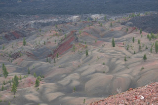
This trail is relatively short--just over 2 miles one way.  The first mile and a half is relatively flat.  The going was somewhat difficult, however, because the foot bed was crushed cinder about the consistency of sand.  I found it difficult and tiresome to walk on.  On the way to the Cinder Cone we passed the Fantastic Lava Beds and got a glimpse of the Painted Dunes.  This area has been very slow at revegetation and there are still very few trees surrounding this cone that erupted about 350 years ago.
Lave Beds
As Cinder Cone came into view, and shortly thereafter, the trail up Cinder Cone, I wondered why I hadn’t stayed home with my coffee cup.  The trip up was slow and labored.  A “two steps forward and a step backward” sort of hike.  We exchanged the sand-like cinder for some of a little larger caliber, but still very small, loose, and conducive to sliding.  It may have been worse than the snow we hiked in yesterday.  The trail was VERY steep. I started out by taking 10 steps, then resting for 5 count.  I increased my steps by 5 until I was able to do 50 before the resting 5 count.  Eventually, I reached the top.  Gene managed to move along a little faster than I and got the first view of the top.

Cinder Cone has two rims--an inner and an outer rim.  We hiked down to the inner rim to cross to the other side of the crater.  There was a trail that went down into the center, but I could see it just fine from where I stood.  No need to go down there.
Lassen Peak as seen from top of Cinder Cone
Hikers have the option of descending by the trail they came up or using the trail on the opposite side of the cone.  We chose to go down this other trail which was, if anything, steeper than the one we came up and only about half as wide.  We both fell once.  I got to where I would just put my foot down and then ride out the slide.  When I stopped, I’d take another step.   We finally reached the bottom without major injury.  By coming down this side, we had fantastic views of the painted dunes.  We also had great views of Lassen Peak from the top.
Painted Dunes with lava beds in background
This was a new experience for me and I am glad I went.  But once is enough.  I’m glad Mount St. Helens is still covered in snow.  I wont be tempted.


Tomorrow morning we hit the road again.  Our destination for tomorrow evening is Crater Lake.  Oregon, at last.

Thursday, June 18, 2009

Lassen Volcanic National Park

Lassen was designated a National Park in 1916 to preserve and study this active, though dormant, volcano and the resulting landscape following its eruption in 1914.  There are four different types of volcanos within the park--shield, plug dome, cinder cone, and composite volcanoes.  There are also hydrothermal areas of steaming vents, boiling water, and bubbling mud pots like those seen in Yellowstone.
Lassen Peak, world's largest plug dome volcano
The snow only recently melted enough to allow the main park road to be opened to the public.  Still, the high elevation trails are covered in snow.  Today we drove the park road and stopped along the way at pullouts and trailheads to get a closer view of the landscape.
Chaos Crag

Small rocks cover the ground
Larger rocks near the top of the trail


Our first stop was near the north entrance station at the trailhead for Crags Lake.  The ranger we spoke with yesterday recommended this 3.6 mile round trip moderate hike up to the small lake formed when Chaos Crags blew it’s top.  The hike was nice through pine forest, but with a pretty steep uphill climb of just over 800 feet.  They put all the steep part together and there was more gentle, almost level, trail at the beginning and near the lake.  When we got to the point where the lake finally came into view, we were somewhat disappointed in the tiny pond that awaited at the bottom of a steep downhill.  We didn’t go down there.

After this hike, we drove over to the picnic area on the south end of Manzanita Lake for our lunch.  With a vigorous workout under out belts, it was easy to devour everything in the little cooler.
View of Manzanita Lake from our lunch spot
Back in the truck, we drove the main park road almost to the southern entrance to the Bumpass Hell parking lot.  This is the hydrothermal area and one of the most popular features of the park.  We told the ranger we were interested in seeing this area and she told us there was still some snow up there, but that the trail crew had been out and it was passable. She might not have actually recommended this hike, but we felt it was doable based on her description.  Well, I’ll have you to know there was some snow up there--about 4 feet of the white stuff stretching almost the entire 1.5 miles to the thermal basin.
Diamond Peak

Ice is breaking up on Lake Helen
There were a lot of cars in the parking lot and we could see several folks making their way coming or going to Bumpass Hell.  Despite the large orange sign that pronounced the trail hazardous, we stepped out onto the snow with all the rest.  When we got to the point where the basin finally came into view, we were exhausted and somewhat disappointed to find the boardwalk through the mud pots and steaming vents awaited us at the bottom of a steep downhill.  We didn’t go down there.  I was content once again to make my photos from my perch high above.

Bumpass Hell
On our return trip over the main park road we stopped at a couple overlooks and points of interest.  By this time we were pretty tired puppies and just wanted to be home.

Tomorrow we have a hike planned up the Cinder Cone Volcano.