Rocky Top--not the song, but the place.
I’d venture to say that just about everyone in Tennessee is familiar with “Rocky Top”, that country/bluegrass tune recorded by the Osborne Brothers sometime in the late 1960s. Somehow, “Rocky Top” made its way into becoming one of the state songs in Tennessee and the marching bands of the University of Tennessee have filled, not only Neyland Stadium, but all of East Tennessee with the rousing chords of “Rocky Top” during every football season for the past 40 years.
Contrary to popular belief, Rocky Top is not Neyland Stadium nor the University of Tennessee though you’d be hard pressed to prove that on game day. As far as I know, the song writers of Rocky Top didn’t have a specific place in mind, but a place definitely exists. And, wouldn’t you know--it’s in Great Smoky National Park and it’s definitely UP hill. And, the best part of all (for me, at least) is the Appalachian Trail runs right across the top of Rocky Top.
There are several ways to get to Rocky Top. Since Rocky Top is on the AT, it would be possible to walk there either from Springer Mountain in Georgia or Mt Katahdin in Maine. Allow plenty of time. Rocky Top sits high above Cades Cove on the Tennessee side and Fontana Lake on the North Carolina side of the Park. Any of the trails leading to the AT from either of those places will get you there. One popular route is to take Anthony Creek Trail from the back of the Cades Cove picnic area. Many hikers opt to create a loop by adding Russell Field Trail, the AT, and Bote Mountain Trail to Anthony Creek Trail with a little side trip to Rocky Top. Some strong hikers can do that 15-mile loop as a day hike, but most backpack and stay either at Spence Field or Russell Field shelters. These are all fine ways to get there, but we were looking for the shortest route since it was going to be a long, hard day hike for us.
Our hike began at the Lead Cove trailhead. This is at that same parking lot we used several times recently for Turkeypen Ridge Trail and Finley Cane Trail. We were at the trailhead early and on the trail by 8 AM. Not many folks were out on this cool fall morning. Lead Cove trailhead is at 1700 feet in elevation and rises in 1.8 miles to 3000 feet where it junctions with Bote Mountain Trail. It’s a steady climb, but since we would be climbing all the way to our destination, we soon settled into a pace we could sustain for the duration.
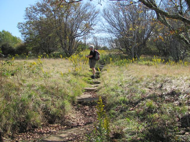
The trail junction sign at Bote Mountain was a welcome site and we quickly threw off our packs and had a seat on the ground for a short break.

Bote Mountain was the next hurdle--2.9 miles with nearly 2000 feet of elevation gain. It helped me to think of this stretch in two sections. First was the 1.2 miles to the Anthony Creek Trail junction. This section is typical of Bote Mountain Trail--the wide old roadbed. We continued our steady climb and were at Anthony Creek junction in good time, more than ready for another short break. Not far beyond this junction we came to a very wide spot in the trail. This was the end of the road for tourists coming up back in the days when Bote Mountain was still open to cars. Beyond this large turnaround, the trail narrows and begins the final 1.5 mile push to the top. Before the establishment of the National Park, this was a primary route used by farmers to herd their cattle for summer grazing at Spence Field. The trail is deeply eroded in this section; almost like walking in a gully. Of course, hikers, horses, and weather have played their part, but the cattle did the most damage.
Another break was in order at the junction of Bote Mountain and the Appalachian Trail. To the right two-tenths of a mile is Spence Field Shelter. The shelter has been renovated as the other shelters in the Park. It would be a nice place for lunch, but we didn’t want to add the distance to our already long hike.
 |
| Our destination is the peak in the middle, but first this little bump straight ahead |

To the left was our destination just about a mile away. This little mile section was our favorite as far as scenery goes. As you know, we love it at high elevation and this edge of Spence Field offered some open, grassy areas with magnificent views. Plus, it wasn’t all up hill for a change. From the junction with Bote Mountain the AT gently climbs 300 feet, but then quickly loses 200 of those feet before the steep 400 foot climb to the summit of Rocky Top.

As we stepped onto the summit, I had the camera out to get what photos I could before the clouds moved in. We found a rock for lunch and enjoyed the splendor of these magnificent mountains over a cup of hot tea and a sandwich.


Thunderhead is just a short distance away, but we chose to sit on Rocky Top and rest our weary bones.

What goes up must come down. We stayed as long as possible before packing up and starting the long journey to the car. We were two tired puppies at the end of the day, but, oh, what an awesome hike. We’ll savor the memories of this one for a long time.
 |
| Cades Cove far below |
Wow! Great views! And looks like some fall color too. Nice hike!
ReplyDeleteGreat post. I always wondered where Rocky Top is. Nice photos, but I'm tired after reading about the hike and my knees hurt from that downhill trek. It must be nice to be young.
ReplyDeleteThanks for the tour to the top of Rocky Top. Now I'll be humming that song for the next few days.
ReplyDeleteGreat shots. I definetely need to look into visiting as soon as I buy one of the used rvs in PA.
ReplyDeleteKeith