We were back on the trail again today after two rest days and then two rain days, but the story of today’s hike will have to wait until I have the energy to remember the details.
We’ve been hiking in the Smokies for somewhere around thirty years. That’s a very long time. These mountains are almost like a second home to us and when writing the blog I sometimes make comments that are perfectly clear to me because I’m so familiar with the area, but may be very confusing to others.
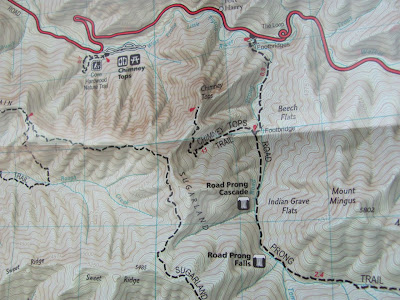
I’ve been talking about my trail map like everybody in the world should know what that is. Pam and Wayne brought me to my senses by asking about the map. So, here’s an answer for them, and it’s probably way more than they every wanted to know.
There are actually two maps which we use when hiking. One is a small map published by the National Park which shows all the roads inside the park, the major roads on the perimeter, and all the hiking and horse trails. The trails are marked by name and include distances between junctions. These maps are available for purchase at all the Visitor and Information Centers, gift shops, and sometimes at the campgrounds in the park. They’re only a dollar.
The other map we use is a National Geographic Trails Illustrated map. Actually, this is a set of 3 maps. These maps are huge topo maps and give lots of detail and information. We especially like the fact that footbridges are marked. If you’re familiar with Trails Illustrated maps, you know they are waterproof and durable--good for taking on the trail. Each map can be purchased separately for $10 each. The set of 3 maps is slightly cheaper, but it’s not a substantial savings over the individual price.
Great Smoky Mountains National Park maintains somewhere between 800 and 900 miles of trail. Well, you know people looked at that number and said, “I want to hike them all”. That has evolved into a real big deal--the “900 Club”. When you’ve hiked all the trails, you can even get a patch from Smoky Mountain Hiking Club if you want to jump through all the hoops for that.
The map that most people use to color the trails as they are completed is the dollar National Park map. Of course, for a dollar you don’t get much and the paper is cheap and starts to rip at the folds almost immediately. My map has so much scotch tape on it I’d say it’s laminated, but only on one side otherwise the highlighter color won’t stick.
My map came with the “bible” of Smoky Mountain trails--Hiking Trails of the Smokies put together by the Great Smoky Mountain Association. There is no single author; the trail descriptions were contributed by several hikers. The book was first published in 1994 and I have a 1997 Revised copy. Since the original publication, there have been 3 editions. The last, which is the book Gene uses, was done in 2003. This is truly “the” trail guide for the Smokies. Almost every serious hiker of the Smokies has one. It has been a huge money maker for the Association and much of that money goes back into trail improvements.
For each trail in the Park the book gives a hike description, directions to the trailhead, highlights of the trail, and whether it is used by horses. The book also includes a trail profile for each trail. Sometimes that good; sometimes it’s better not to know.
 |
| We came down this trail today. |
 |
| My map |
So, Pam and Wayne. Hope that answers your map question--yes, there is a trail map, and yes, it is a detailed trail map. I suppose a simple “yes” would have worked. But now you know just how crazy those of us are who are trying to color that damn map.
By the way, Pam and Wayne have recently visited Great Smoky Mountains National Park and have several blog entries of their adventures including bear encounters. Check out their blog, Nomadic Newfies, for a whole different perspective of this great park.
That’s it for today. Thanks for tagging along.


Thanks for the explanation on the trail maps. That's a whole lot of trails and miles to hike!
ReplyDeleteWow! I had no idea there were so many trails or a 900 club.
ReplyDeleteYou may also download a PDF file of the trail map at http://www.nps.gov/grsm/planyourvisit/maps.htm.
ReplyDeleteBill (The "Lost" Hiker)
Thanks, Judi! I did download the PDF trail map on the nps website and it didn't hold up very well for just the few days we were there! It was also very hard to read and didn't really provide any detail for getting to most of the trailheads. I had also bought a book "Day & Overnight Great Smoky Mountains" which had great (but lengthy) descriptions but was in no way a complete list. That's where I read about the Injun Creek hike I took our last day there. Looking forward to getting back again, probably fall next year to see it in a different season. I'll make sure to pick up one of the books you mentioned before we do!
ReplyDeleteYou should be able to zoom in once you download the PDF. Then it's just as detailed as the one you buy. You can also take a "snapshot" of the area you're planning to hike and just print that part of the map.
Deletebill
Just checked out the Smoky Mountain Association website and am going to purchase their book. Bargain for $20.95 on lightweight paper! Thanks again!
ReplyDelete