It has been difficult for me to decide how to tell this story. Instead of describing our trip in chronological order, I’ve finally decided to make it a three-part series and tell different aspects of the trip in each posting.
Let me just say here at the beginning that we did not go all the way to Inuvik. I’ll explain why in another posting.
We were eager to get started, but the getting started process seemed to take forever. We were just taking the car, so everything we normally store in the car had to be moved to the motor home and everything we were taking on the trip, which seemed to be more and more with every breath we took, had to be loading into the car with much consideration being given to making the litter box available to the Peanut. I wish I’d taken a picture of the inside of the car. It was pretty remarkable.
The Dempster Highway begins at Dempster Corners twenty-five miles east of Dawson City. At Dempster Corners is one of those combination hotel, restaurant, campground, gas station, auto repair shop places, Klondike River Lodge, and Gene had arranged to leave the motor home in storage there. We got that all squared away and filled up the car with gas. We were finally ready to begin our adventure about 10 AM Tuesday.
The Dempster Highway is one of only two roads in North America that goes above the Arctic Circle. From Dempster Corner, which is mile “0”, it runs ever so slightly northeast for 457 miles to Inuvik, Northwest Territory. The first 2.5 miles are paved and the last 2.5 miles are paved (I think); everything in between is gravel, dirt, or mud.
The highway is named after a Royal Canadian Mounted Police Inspector. Before the Dempster was a real road, it was a dog sled trail and Inspector Dempster ran his team of dogs between Dawson City and Fort McPherson, the first town after crossing into Northwest Territory.
Because of the boom in oil and gas exploration in the far north during the mid 1900s, the Canadian government decided to build a road to connect Dawson City and Inuvik. With the discovery of oil, road construction actually got started, but was a slow going project and a true road didn’t materialize until the late 1970s. Originally, only open during the summer, it is now an all weather road and open year round.
Tombstone Territorial Park is the first major attraction along the highway. The park boundary is at mile 30 and extends for 42 miles. Tombstone is typical of American State Parks with a very nice Interpretative Center staffed by Park Rangers, ranger led walks and talks, hiking trails, and a campground.
We stopped at the Interpretative Center and looked at the displays about the building of the highway and the natural features of arctic tundra.
Just past the Interpretative Center is the park campground. It was too soon to stop for the night, but we drove in just to see what we could see. It is very much like the other Territorial Campgrounds we’ve stayed in on this trip. The campsites are spacious and surrounded by trees. Each site has a fire ring and picnic table. Since this is serious grizzly country, there was also a kitchen shelter so you wouldn’t have to cook close to where you would be sleeping. They also had food storage lockers and a pulley system to hang your food like we are used to in the Smokies at the backcountry campsites. There were plenty of pit toilets and garbage containers. There was water, but it was not drinkable until it had either been chemically treated or boiled.
Beyond the Interpretative Center and the Campground came the lakes, ponds, and rivers. As we drove farther north, we began to see more trees again. The lakes disappeared, but we always seemed to have a river nearby. The road is on the ridgeline in many places so the views were expansive. It was like you could see forever--Russia and beyond.
 |
| View from the Interpretative Center |
The drive along the highway for the first 100 miles was, in our opinion, the most scenic of the 250 miles we drove. The high mountains and the lakes were just beautiful. The land was basically treeless with just the low scrub of the arctic tundra. Fascinating! We would recommend this drive to anyone who finds themselves in the area. If you don’t want to drive the entire highway, at least this first section is worth the effort.
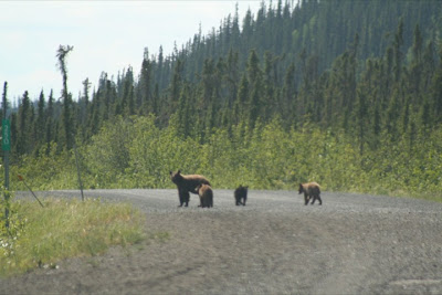
CRITTER COUNT: The first day, we were disappointed to not see more wildlife. That was one of the main objectives of the trip. We drove 229 miles the first day and only saw 1 snowshoe hare and a moose. The second day, however, the bears came out to play. At two different locations we saw a lone bear, then the mom and her three cubs crossed the road right in front of us.
That’s about it for this first installment. More to come. Thanks for tagging along.


No comments:
Post a Comment