Showing posts with label Appalachian Trail. Show all posts

Tuesday, August 7, 2012

Trail Shelters


Whenever we wander by a shelter I usually make a picture then post it along with the story of that hike.  One of our faithful followers, Rick (Rick and Paulette’s RV Travels) usually makes a comment about the shelter.  The last shelter I mentioned in the blog was Mt Collins shelter in the Sugarland Mountain Trail post a few days ago.  Rick commented that he thought the shelters were a nice thing for hikers.

Thunder Hill Shelter in Virginia
You are absolutely right, Rick.  Most hikers really appreciate the shelters.  They’re certainly a welcome sight at the end of a long day, especially if it’s been raining.  Since Gene and I usually just stop in a shelter for lunch or a short break, I usually don’t say much about the shelters in a post.  So I thought I’d just share a few of my thoughts about trail shelters.

Trail Shelters are not the same as the “huts” in the High Sierras, Colorado, or the White Mountains.  Those huts are owned by Clubs or concessionaires and must be reserved and paid for to stay.  Trail shelters I’m talking about are structures along trails for overnight stays by hikers and usually require not reservations and are usually free.

Blood Mountain Shelter in Georgia
Trail shelters are not exclusive to the Smokies.  Although they can be found across the country, they are more common in the east and particularly along the Appalachian Trail.  Perhaps the model for the most common type of shelter was the “lean-to” found in the Adirondacks in New York.  Although we’ve seen many sizes and shapes of shelters constructed of various materials, by far the most common are the 3-sided log structures with a wooden sleeping platform, usually large enough to sleep six.  Often a second sleeping deck is added above making a “bunk bed” and doubling the sleeping capacity.  If you’re lucky, there’ll be a ladder to the upper bunk.

Deer Lick Twin Shelters in Pennsylvania, I think.
Gene and I don’t like to sleep in the shelters.  However, when on a long distance hike on the AT, we usually pitch our tent near the shelters.  The reason we don’t like to sleep in shelters, besides not wanting to sleep with 8 to 10 snoring strangers, is that shelters are rodent-ridden hovels.  The mice are bad enough, but I draw the line with the snakes that come for the mice.  Mice are definitely a problem; snakes not so much.  I’ve seen a few snakes at shelters, therefore, in my mind, they’re always there just lurking in the shadows waiting for me to fall asleep.

Tumbling Run twin shelters separate snorers and non snorers.
I especially like the clothesline in back.
The shelters offer some advantages when backpacking.  The main one, of course, is water.  Water is not just everywhere on the trail.  The shelters are built near a water source. The water still needs to be treated before drinking, but at least it’s usually easy to get.

Quarry Gap Shelter in Pennsylvania
Another advantage is often a picnic table or sitting log which makes cooking easier.  Many shelters along the AT now have cooking porches added which gives hikers a dry place to cook if it’s raining.  Cooking and eating in the sleeping area is a big “NO-NO” as food odors attract wildlife (bears).

Some may say the best advantage of being at the shelter is the camaraderie with other hikers.  It is nice to have company in the evening to swap tales of the trail.

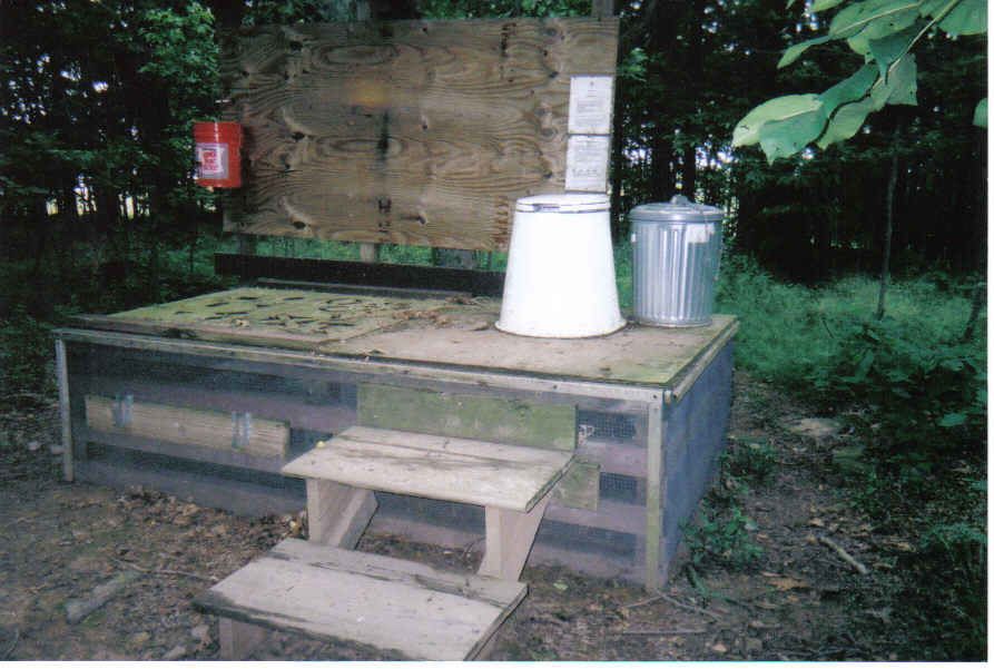
Privy in 100 mile wilderness in Maine

I also like camping near the shelter because most have privies.  Personally, I hate digging a cat hole.

Icewater Springs Shelter in the Smokies
The shelters along the AT are the ones we’re most familiar with.  The AT Clubs have constructed shelters about 10-15 miles (one day’s walk) apart for the entire 2100 plus miles of the trail.  Some of these shelters are getting pretty old now.  Smoky Mountains Hiking Club maintains the AT through the National Park and in recent years renovated the shelters we’ve been stopping in on our day hikes.  They’ve added skylights, cooking porches, and replaced the roofs and sleeping platforms.   These shelters are very nice now.

Partnership shelter in Mt Rogers Recreation Area.  This one has a shower.
Along the AT it is permissible to pitch a tent in the vicinity of the shelter.  In some places there are even wooden tent platforms or gravel pads for tents.  There are some exceptions; however, and the Smokies is one of those exceptions.  The only time tents are allowed at shelters is during thru-hiker season and the shelter is full.  On our first section hike we were heading to Newfound Gap from Springer Mountain.  That meant 2 or 3 nights in shelters in the Smokies.  I worried from the time I got on the trail at Springer Mountain all the way to Fontana Lake at the edge of the Smokies about staying in a shelter with the mice and snakes.  I finally came up with the idea to sleep inside the tent body.  Gene used rope to attach the tent to the upper sleeping platform.  The tent wasn’t pitched inside the shelter and I wasn’t taking up any more space than I would have with just my sleeping pad. The best thing--nothing could crawl on me.

My nest safe from creepy crawlies
Here are a few pictures of shelters we’ve been privileged to pass by.  Some we’ve stayed near; some we’ve stayed in.

Ed Garvey Shelter
Privies are as varied as the shelters.  They range from the open air style (great views) to the new ones which must be handicap accessible.  We came across this new privy at the Matts Creek shelter in Virginia.  The trail crew (all volunteers and all senior citizens) were just putting on the finishing touches.  For privies built on federal land, handicap accessible regulations apply.  It doesn’t matter that the nearest road is 5 miles away.


That’s about all I know about shelters and it's probably way more than you ever wanted to know.  Thanks for tagging along.

Wednesday, June 13, 2012

Appalachian Trail to Silers Bald


After a week of not hiking, we were back out there today.  With the warmer temperatures we’re selecting higher elevation trails.  Today we drove up to Clingman’s Dome for a walk out the AT to Silers Bald.


Our hike started with a half mile hike uphill on the paved path which leads to Clingman’s Dome observation tower.  The Appalachian Trail passes next to the tower and we headed south.  It was a pretty clear day so the views were special. This section of the AT traverses the ridge and offers spectacular views from both sides of the trail.


We took our time walking down (everything is down from Clingman’s Dome, the highest point in Tennessee) to Silers Bald.  We stopped to enjoy the views and we talked with several other hikers who were headed north on the trial.


A little over halfway we reached Double Spring Gap shelter.  It was a good spot for a break.  Like the rest of the shelters in the Smokies, it has been renovated recently.  The benches and cooking porches are a real improvement.  The skylights make such a big difference inside the shelter.  It is actually light inside and not so dark, dank, and dreary as in the old shelter days.


Most, but not all the shelters in the Smokies have composting privies.  This one at Double Spring Gap shelter is of the open air style.  Talk about a room with a view.


Immediately past the shelter, we saw a deer back in the woods.  He was well hidden and I only got a glimpse of one eye and a nose.  Shortly after the deer sighting, we found this cute bunny in the trail.  The trail maintaining crew had recently passed this way with a sling blade or weed eater.  I guess the bunny thought lunch had been served.  He was happy as a lark munching on the cut vegetation.  We stood still on the trail and he came right up to us.


Silers Bald was once an open bald, but not so any longer.  It has been reclaimed by trees and there are no longer any views from the bald.  There is a large rock with AT blazes and arrows painted on it.

We saw this bird, but I haven't a clue what he is.
We continued on past the bald to Silers Bald shelter for our lunch.  After a nice break we headed back to the car.  The return trip was mostly uphill, gaining that 1000 feet we lost as we came off Clingman’s Dome.

Clingman's Dome Parking lot.  We still have a way to go yet.
We made one change on the way back.  We went down the Clingman’s Dome Bypass trail instead of going on up and taking the paved path down.  That was a mistake as that trail was rough, rocky, and wet.  It could certainly use a little maintenance.


Besides the bunny and the views, the highlight of the day was the flame azalea in full bloom along the trail.  Really, the whole hike was great.  It is one of our favorites in the Smokies, even if there is that big climb at the end of the day.


We are glad to welcome our latest follower, Dell.  Thanks, Dell, for tagging along.

That’s all for today.  Thanks for tagging along.

Wednesday, March 14, 2012

Appalachian Trail Up Blood Mountain

Our hike today was awesome.  Perhaps part of that feeling of awe was due to our eagerness to get back to some mountain hiking after a couple months in Florida.  Other factors contributed to a great hike--the weather was just about perfect, we had fabulous views from the top, and we saw dozens of young hikers bubbling over with enthusiasm as they get started on their quest to hike the entire Appalachian Trail.

We were also very pleased with how well we did for a first mountain hike in a very long time.  The trail from Neels Gap to the summit of Blood Mountain is 2.4 miles with 1336 feet of elevation gain.  We made the summit in an hour and forty-five minutes. We really didn’t take a break.  We stopped once and sat on a rock to rest for about 5 minutes.  However, we stopped often to talk to the hikers coming down the mountain to Neels Gap.

There are numerous legends about how this mountain got its name.  One of the more popular tales involves the Creek and Cherokee Indians.  Before this area was inhabited by the white man, these two Indian nations engaged in a battle so fierce that the creeks coming down the mountain side ran red with blood.

We began our hike southbound on the AT at Mountain Crossings.  The outfitter was kind enough to let us leave our car in his parking lot.  Their parking lot isn’t very large and they get a lot of business so they ask that day hikers park at a parking lot a quarter mile down the road.  I’m sure they wouldn’t have been so accommodating later in the season.  We were grateful for their kindness today and probably spent more in the store than we otherwise would have.

From Mountain Crossings we crossed to the other side of US19 and started up the hill.  Almost immediately we came to a sign welcoming us to Blood Mountain Wilderness Area and Chattahoochee National Forest.  Being the AT, the trail is blazed in white.  Being the beginning of thru hiker season, it was very evident that the Georgia AT Club had been hard at work to get their section of trail in topnotch condition for the hikers coming through.


The first mile of the hike was on primarily dirt through eastern hardwoods and laurel thickets.  After about a mile we came to Flatrock Gap and the trail junction with the Byron Reece Trail.  We continued up hill.

The second mile was considerably steeper than the first gaining most of that 1300 feet.  The trail also changed from dirt to rock.  As we approached the summit we were walking across large slabs of granite.  It was in this section that we had the best views.

At the summit, we stopped for a few minutes at the Blood Mountain Shelter.  This old stone building has the reputation for being the coldest shelter on the AT.  The building dates back to the 1930s.  We think it was built by the CCC as a trail shelter.  It has concrete floors and stone walls.  The fireplace has been bricked up.  It looks like the roof has been recently replaced.  There were lots of hikers hanging around so we only stayed a few minutes.

Out in the sunshine and a much more enjoyable place for our lunch break was back to one of those granite slabs.  We found a spot not too close to the edge to take in the view while we ate.  Gene even made us a cup of hot chocolate.  We had our dessert at Mountain Crossings after the hike--an ice cream bar.  They had a freezer full of pints of Ben and Jerry’s, but we hadn’t hiked nearly enough miles for that.

Our descent was a little faster than the ascent.  We both put on knee braces to come down that steep section at the top.

Mountain Crossings deserves a whole story for itself.  It is a special place.  I’ll save that for another day.

I think that about does it for today.  Thanks for tagging along.

Saturday, September 11, 2010

The Hardest Mile


We were out for another hike today.  Short hike, but a very long drive to get to the trailhead.  I think we made a loop around the entire Mahoosuc Range.


For years we have heard of the infamous “Mahoosuc Notch”.  By most who have hiked the entire Appalachian Trail, it is considered to be the hardest mile.  This mile long section of trail is filled with boulders some say are the size of small cars and are turned in every direction.  A few years ago a moose wandered into the notch and was unable to get out.  They say his bones are still there.  The hiker who is brave enough traverses this section by climbing over, under, and around these huge boulders that have fallen off the side of Mahoosuc Mountain.  Don’t expect to do the standard 30-minute mile through here.  I’m not sure what the average time is, but it can easily take two or three hours.


Gene and I didn’t want to hike through there, but we did want to have a look.  By studying the map, we found a short, relatively easy trail that took us right to this infamous notch.  The Notch Trail (pretty aptly named, don’t you think) started on an old logging road not so far from our campground--as the crow flies.  Of course, our truck couldn’t get there as the crow flies, so we went around.


We went east on US 2 into Maine and then turned north on route 26.  As we passed through Grafton Notch State Park, we stopped for just a minute to view Screw Auger Falls.  It wasn’t a spectacular, high waterfall, but pretty anyway.  We found where the AT crosses route 26 then were on the lookout for our turn.  Success Pond Road is a dirt logging road that runs from Berlin, NH to Grafton Notch, ME a distance of about 22 miles.  We turned on Success Pond Rd, slowed down to about 15 mph and headed back toward New Hampshire.  Finally, after about an hour we found the tiny, single lane, dirt road off the dirt logging road which took us to the trailhead.  Surprising, there were three other cars in the small parking area.


As we started our hike, we thought we had hit the jackpot as far as trails go.  It was wonderful--no rocks, roots, or ruts with a very gentle incline.  This perfect trail didn’t last very long, but never got really bad either.  There were a few rocks and slippery roots and the grade got a little steeper, but all in all it was a very pleasant walk along a small mountain brook.  We got to cross that brook three times, but all crossings were easy--just rock hops.


At the top, our trail ended right at the junction of the Mahoosuc Trail (AT) at the south end of Mahoosuc Notch.  At this elevation today we were in the cloud and everything was wet and a very fine mist was floating in the air.  We wanted to get a good look at the notch so we headed down.  A short drop brought us to an open spot and then it was up again over roots and around trees to the next down.  We didn’t do that down.  It went around a tree and then straight down into the cavern of boulders.  The next white blaze I could see was on the side of a boulder that didn’t look like it could be scaled.  We wanted a look at the notch and we got to.  Then we were out of there.


For our drive back home, we continued west on Success Pond Rd.  This side was much rougher than the first half and we crept along at about 10 mph.  At one point, we came upon a taillight that had fallen off someone’s car.  That was kinda funny until we got home and found one of our mud flaps barely hanging on.


At dinner tonight while reflecting on our hike, we both agreed it was way cool to be in “Mahoosuc Notch”.  But perhaps our favorite thing about the hike was the distinctive “north woods” feel of the forest today.  It was awesome.


Storms are moving into our area over night tonight so tomorrow will be a chore day.  It’s just as well since my laundry basket is overflowing.

That’s it for today.

Monday, September 6, 2010

Cody


Well, this is a long story that goes way back to early spring.  It is one of those things that just happened without planning and has been a joy to watch it unfold as the months have passed.  This story is about Cody.

Way back last winter, we made plans to come to New England as the support team for Herb and Dwight.  Because we were doing that, we also decided to do a little hiking ourselves to add a few miles to our existing AT miles.  Those plans put us somewhere along the AT for the entire season.  Wow!  Because we were going to be closely associated with the trial for that long, We decided to follow a few of the thru-hikers via their trail journals.

Like many RVers who share their adventures by means of an on-line travel journal or blog, hikers also post trail journals.  Probably the most popular host for the AT hikers is Trail Journals.com.  I searched through the list of hikers for this year and selected about six to follow.  It wasn’t a totally random selection. I wanted more mature hikers rather than those in their 20s, but other than that distinction, I didn’t know anyone of those selected.   Over time, other hikers were added to my list.  One name I got from the owner of an outfitter in Maryville, TN when I was paying for my purchase, but most of the additional hikers are people we’ve met along the trail ourselves.


Cody is from my original selection--one from a list of hundreds hiking the trail this season.  After I had been following Cody for several weeks I learned she is from Tennessee (Cookeville area) and is a member of Tennessee Trails, our own hiking club.  What a coincidence.  You cannot imagine our surprise when Cody was met by one of her good friends in Hot Springs, North Carolina and that friend turned out to be a friend and high school classmate of Gene’s.  Holy Cow!


Needless to say, we have taken a special interest in Cody.  We’ve been avid readers of her trail journal keeping up with her progress on this 2100-mile journey.  While we were hiking in Northern Virginia, I knew Cody was close at hand.  Because the hikers are unable to post to their journals every day, to pinpoint one of them is very difficult.  But every day that I was on the trail, I had my eye out for Cody.

Because we didn’t hike every day and because we took a week off for a trip to Nashville, and another week off visiting with friends, Cody got past us. It wasn’t until Maryland that we finally ran into her.  Gene got the honors.  He met her on the trail in Maryland just north of Harper’s Ferry.  I figured my chances of seeing Cody were pretty slim after that.

Now that we are sitting in Gorham, New Hampshire, most of those hikers I’ve been following have come into the Whites.  All of a sudden I realized we’d still be here when Cody arrived.  Yesterday, my dream came true.  Cody arrived in Gorham and we met her for dinner.  Stick Walker (and his dog, Belle) was also in town and he joined us for dinner, as well.


This morning, we gave Cody, Stick Walker, and Belle a ride back to the trail.  With hugs, best wishes for success, and goodbyes we watched as they crossed US 2 and headed north.


By being so close to the trail and seeing and speaking with so many of the thru-hikers, we have gained a much deeper appreciation for their level of endurance.  It’s not just a physical feat to walk 2100 miles.  It is physically demanding, of course, and if you’re not in shape when you start, you certainly are within a few weeks.  But it is also a very mentally demanding endeavor.  This may very well be the most challenging aspect of the hike.  It is hard enough for me to keep a positive mental attitude when the gray water tank gets full during my shower, or something I need for dinner is not in the local grocery, or the wind is blowing too hard to put the awning out.  I can’t imagine the mental stamina required to keep moving forward day after day, mile after rocky mile in all kinds of weather with your only creature comforts slung on your back.  They face the challenges of the trail and their own personal fears head on and keep on walking.  The thru-hikers are remarkable people.


Good luck, Cody, Stick Walker, and Belle. Just 297.9 miles to go--”all the way to the top”.

Saturday, September 4, 2010

Shuttle Truck


Sometimes your plans change in mid-stream.  That’s what happened to us yesterday.

We went out for a little hike; one that we had done before, actually.  Because it was close and easy, we started southbound on the AT just a mile from our campground where the trail crosses US 2.  Right away after we started, we met a thru-hiker coming down.  We spoke and went on our way.  Shortly, we met another hiker.  Again, we spoke and continued on our way.  After about a mile, we met yet another hiker.  This guy was a real talker, so we chatted for several minutes.  On a whim, we decided, while standing there in the middle of the trail, to walk back to the road with him and take him to town.  It was the right thing to do.  He was a nice guy, he needed a ride to town, we had a truck and really nothing else to do.  Certainly, not anything any more important to do.


When we got back to the parking lot, the second hiker we had met was trying to get a hitch.  We grabbed him and all piled into the truck.  Well, actually, they got in the bed with their packs--they were far too dirty to sit in the truck.  We gave them an ice cold cola and they were happy as larks sipping their cokes and letting the wind blow the smell away.


We dropped them off at the laundry mat (that’s where they wanted to go, not where we decided they needed to go) and we turned to go back to the trail.  On the way out of town we saw a young thru-hiker couple trying to hitch a ride back to the trail.  Since that’s where we were going, we picked them up.  As we pulled into the parking lot to let the young couple out, along came Big and Little Foot, a dad and son hiking team.  Yep, they wanted to get to town, too.

All together, we made three trips into town and shuttled a total of 10 hikers one way or the other.  We never did get our hike finished.


This morning, we went back to the trail.  This time, we had no intention of hiking.  We were there just to run our little shuttle.  About a minute after we pulled up, three hikers came out of the woods.  Today, was not as busy, however.  We took two others plus their two dogs into town, but brought no one back to the trail.

We hung around the parking lot for a couple hours.  About noon, a gentleman and his wife pulled up and unloaded coolers and sacks of food, set out lawn chairs and a folding table.  Trail Magic!!  The fellow had hiked the trail last year.  We often find former thru-hikers doing trail magic.  They were the recipients and now they just want to pay it forward.  Anyway, he and his wife had things well under control food-wise and we knew there wouldn’t be any hiker come out of the woods who wouldn’t want to sit down to that spread.

We came home for our own lunch.  About 2 o’clock we got back in the truck--this time to pick up a couple items from the grocery.  On our way by the trail parking lot, we pulled in to see if anyone was ready for a ride.  They were all too busy eating to think about going to town.  On our way back from the grocery, we stopped again and this time were able to collect a couple hikers needing a ride.

That’s how we’ve spent our past two days.  Not very exciting, but all those hikers really appreciated the ride and we were happy to help them out.