Showing posts with label lighthouse. Show all posts

Sunday, January 31, 2010

Daytona


Although the rain is past, this has nevertheless been a drab day with heavy cloud cover and temperatures only in the low 50s.  We didn’t stay home, however.  Since we hadn’t yet driven around the Daytona area, today was the day.


Conveniently located on the coast, is Florida’s tallest lighthouse.  Standing tall at 175 feet, Ponce Inlet Lighthouse was on our list of things to see.  Apparently, it was on everybody else’s list, also.  When we got there, the parking lot was almost full.  I mostly wanted a picture of the lighthouse to go along with all my other pictures of lighthouses, so we didn’t buy the ticket to climb the 203 steps to the top.  However, if we were in the mood to tour a lighthouse, this would have been one to tour.  This lighthouse complex is somewhat unique in that it also has most of the original light keepers’ dwellings and other original buildings.  One of the buildings houses a large collections of historic Fresnel lenses.

Daytona is famous, of course, for the beaches which are covered during spring break season with several square miles of burnt flesh.  With a stout wind and chilly temperatures, the beach was nearly deserted today.


Another event which puts Daytona in the headlines is the NASCAR Daytona 500 (running in just a couple weeks).  One of our readers suggested we take a tour of Daytona International Speedway.  That sounded like a great idea until I found out the tour cost $50.  I’m not that much of a fan.  I’m not sure we could have gotten a tour today anyway since they seem to be all involved with something they call the Rolex 24.  We did drive by, though.


Just so happened that Barnes and Noble Bookstore was across the street.  We spent a very relaxing couple of hours sipping coffee and looking through a variety of books and magazines.

Tomorrow, we move to Silver Springs where we plan to stay for a month.

Monday, January 25, 2010

Fort Matanzas National Monument


We found ourselves another Spanish fort to visit.  A few miles south of St Augustine on Anastasia Island is the entrance to Fort Matanzas National Monument.


This fort was built by the Spanish in 1742 to protect St Augustine from the British who might try to sneak into town by way of the Matanzas River.  The fort served its purpose, but saw no significant action.  The same treaties that passed Castillo de San Marcos back and forth between countries also passed Fort Matanzas.  However, no one ever occupied the fort after the Spanish left.


The original fort was so badly deteriorated after years of neglect that it had just about fallen down.  The National Park Service came along and put the fort back together again.  The interpreter estimated that 95% of the stones are original.

Fort Matanzas is located across Matanzas River from the Park Visitor Center.  We rode over and back on a passenger ferry.  The interpreter, in period dress, was very knowledgeable.  He was a real talker, too.  After his little speech about the fort, he was more than happy to answer any and every question anyone had.

On our way home, we stopped by the St Augustine Lighthouse for a couple quick pictures.  There was a museum and you could go up in the lighthouse for a fee.  We decided to pass on that today.

We have been invited to Darrell and Judy’s for dinner tonight.  Their friends were to arrive this afternoon, so it should be a lively party.

Saturday, January 2, 2010

Fort Barrancas


Fort Barrancas is one of a trio of forts guarding the northern Gulf Coast at Pensacola.  Now under the direction of the National Park Service, it is part of the Gulf Islands National Seashore which stretches from Florida to Mississippi.
Series of archways in the Scrap Gallery
The Spanish built the first fort in 1698 to defend against the French and British.  That fort, called Bateria de San Antonio, still stands on the site and is open for touring.  Today it is connected to Fort Barrancas by an underground tunnel and we walked through the tunnel to access the Spanish fort.

The only big gun left
As time passed, the French took over the fort briefly before it landed in the hands of the British.  In 1763 the British built another fort behind Bateria de San Antonio.  The Spanish recaptured Pensacola some 20 years later and added to and reenforced both forts.

General Andrew Jackson won the forts for the US in 1814.  After Florida became a state, the Navy saw Pensacola as a great place for a naval yard.  For protection of the naval yard, improvements were again made to the original Spanish fort, now called the water battery and built Fort Barrancas over the ruins of the British fort.
The Spanish Fort
Fort Barrancas and the water battery site on Pensacola Bay and are the top of the triangle of forts which defend against attack from the Gulf.  Fort McRee and Fort Pickens form the points at the bottom of the triangle and sat opposite each other at the narrow passage between the bay and the gulf.

In the late 1940s, coastal forts were deemed unnecessary.  Fort Barrancas along with Water Battery  became part of Gulf Islands National Seashore in the early 1970s.
Pensacola Lighthouse
This afternoon we toured Fort Barrancas and Water Battery.  Not far away is the Pensacola Lighthouse.  We stopped by there for a photo, but didn’t go inside.  These two stops were a bonus for our day trip.  Our primary purpose for coming to Pensacola today was to visit the highly recommended National Naval Aviation Museum.  The brochure claims this museum is “world class” and we have not talked to anyone who didn’t recommend it.  Truly, it is world class and we will recommend it to anyone visiting Pensacola.  More about that and photos tomorrow.

Pensacola is about 40 miles from Summerdale making this a good day trip.  We plan to go back again before we leave here.

Sunday, July 19, 2009

Journey's End for Lewis and Clark

After 4,000 miles Lewis, Clark, and the Corps of Discovery reached the Pacific Ocean.  Our journey today took us to Fort Clatsop.  This was the site where Lewis and Clark and their party wintered in 1805 before the arduous journey back across the continent.
Landing spot on the Lewis and Clark River
After touring the small museum and the replica of Fort Clatsop, we continued north along US 101 crossing the Columbia River on the Astoria Bridge.  Lewis and Clark, et al, actually landed on the north shore of the Columbia in what is now Washington.  There are several Lewis and Clark points of interest in the vicinity, but since our time was limited we went to Cape Disappointment and the Lewis and Clark Interpretive Center.


This was a very nice interactive museum outlining the entire journey with an emphasis on the Columbia River segment.  We could have spent considerably more time there, but with the long drive back to Portland, we had to tear ourselves away.
Cape Disappointment lighthouse

North Head light

View from North Head Light

Tomorrow we are going to hike.  We need to give our legs a stretch after the 5 hours in the truck today.

Monday, July 6, 2009

Yaquina Bay Lighthouses

Our day got off to a dreary start with heavy cloud cover and even a little misting.  The sun finally won the battle, however, and by mid-afternoon had forced the dreariness away.

We expected Oregon to the shrouded in mist and we weren’t going to let that deter us from our goal of seeing the coastline.  I tend to move a little faster in the morning if it’s bright and sunny so this morning I just kept sipping coffee. We finally got started on today’s journey about 10 AM.  We headed north on US 101 with no real destination in mind.  Our intention was to hit the overlooks to get the views and just stop anywhere we found something of interest.
Alsea Bay Bridge
We turned onto 101 and immediately stopped at the Alsea Bay Bridge Interpretive Center.  The original Alsea Bay bridge, one of several coastal bridges designed by Conde McCullough, was built in 1936.  That bridge was replaced in 1991 by this new bridge, but the magnificent art deco towers (2 at each end of the bridge) remain.  While I was off making pictures of the bridge, Gene attended a clamming and crabbing demonstration with the local park ranger.

Driving on up the coast, we stop at a few pullouts for those rugged coastal views.  We soon decided it would be best if we did this on the way back to avoid crossing traffic to get to the coastal side of the highway.


A few miles north of Newport, we found the Yaquina Head light.  We toured the small interpretive center and gift shop then walked the quarter mile out to the lighthouse.  This is the tallest light on the Oregon coast.  We were not the only ones breathing hard after climbing the 114 steps to the light room.  On the rocks in front of the light were colonies of shorebirds.  It was pretty impressive to see so many birds in one spot, but boy did it smell foul.

We couldn’t see the Yaquina Head light without going to the Yaquina Bay light.  This small two-story clapboard light is the only lighthouse on the Oregon coast with living quarters attached.  Being only 5 miles south of the Yaquina Head light, it was really located in the wrong place and so was decommissioned after only 3 years of service.  It is now a museum.

We stopped at Lost Creek state park for a short walk down to the beach and a tour of the campground.  While there we fed our tummies.  It was too windy to be comfortable outside, so we feasted in the truck.
Yaquina Bay Bridge, another McCullough bridge
On our return drive to Waldport, we stopped at several pullouts.  By that time it had cleared and the sun was shining brightly.  Much more appealing photos, I think.

We plan to drive south tomorrow and maybe take in a short hike.

Wednesday, October 1, 2008

Presque Isle State Park

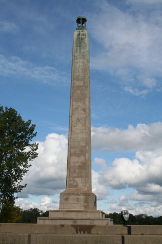
Perry Monument


Today is another rainy day in Pennsylvania. We had planned to drive up to Presque Isle State Park on Lake Erie. Since we don’t have many days here we hated to loose today to rain so decided to go up to the Tom Ridge Environmental Center at the entrance to Presque Isle. We set out early, but when we got there it was closed not opening until 10 AM. Also at the entrance of the park was one of the vintage diners we wanted to see, so we thought we’d wait for Tom Ridge to open drinking coffee. That turned out to be closed as well. Our next thought was to drive into the park. We could look around a little between the rain drops. We got started and couldn’t stop. What a wonderful place.

Presque Isle is a very narrow peninsula approximately 5 miles in length jutting out into Lake Erie at about a 45 degree angle. The road makes a loop along the perimeter with Presque Isle Bay on one side and the Great Lake Erie on the other. Also paralleling the road is a 13-mile long paved path for biking, walking, and jogging in warm weather, and snowshoeing and cross country skiing in the winter. There are also a few miles of woods trails for hiking scattered about the park. There are many inland ponds and small bays which are fabulous for canoeing and fishing. We found one quiet bay area with houses scattered around the bay. They were in a real sense house boats, but they were definitely not boats. We couldn’t decide if they were privately owned or park rental units for visitors. On the lake side were perhaps 12 picnic areas along the sandy beach of Lake Erie.
Presque Isle Bay
North Pier Light

There is a Coast Guard Station on the tip end of the peninsula and about midway on the Lake side is the Presque Isle Lighthouse. We got good views from the beach, but we could not get too close to the light since it is now a private residence. Our guess is that the local Park Ranger lives there or perhaps someone who has volunteered to maintain the structure.
Picnic area on Lake Erie


Presque Isle is the place where Commodore Perry hid out from the British while building his ships. He went from here with his fleet to win the battle against the British in the War of 1812. Naturally, to show our gratitude, a memorial has been erected in his honor at Misery Bay were Perry’s men wintered on their ships following the battle.
Misery Bay

Little house boats on Horseshoe Pond
Presque Isle Lighthouse

Gene had a conference call at noon so we couldn’t stay as long as we would have liked. If we get a chance before we leave here, we’ll go back. Besides, we never did get to visit the Tom Ridge Environmental Center.

Saturday, June 28, 2008

Sodus Point Lighthouse

In our wandering around on Friday, quite to our surprise, we stumbled across Sodus Point Lighthouse. I enjoy lighthouses. There is something majestic and a little romantic about them that piques my imagination.

The “Big Sodus Light” was built in 1870 and served as a beacon to seaman on Lake Ontario until 1901. This was the second light on this site; the first having been erected in 1825. Now, as is the case with so many lighthouses, it is a maritime museum.

The lighthouse, as well as the grounds, are immaculately maintained by the Historical Society of Sodus Bay. We strolled around enjoying the flower gardens, the view of the lake, and the serenity of this peaceful place. By the time we got there, the sky had darkened further from when we were at Chimney Bluffs so the delineation between lake and sky was almost impossible. But, here that seemed to add to the light’s romantic appeal—perhaps a mysterious dimension.
Flower garden on the lighthouse lawn

Our quiet time of meditation was interrupted by the wedding party coming for rehearsal. What a beautiful place for a wedding—if only the sun will shine.