Showing posts with label Bankhead National Forest. Show all posts

Saturday, December 3, 2011

A Sipsey Wilderness Adventure

With rain in the forecast for early next week, we wanted to get in as much hiking as possible.  This morning we headed back over to Sipsey Wilderness to hike the Rippey Trial.  Now that we knew there is no hunting in the area where we would be hiking we got an earlier start this morning.  We drove the 50 miles and were at the trailhead by 9:30 AM.
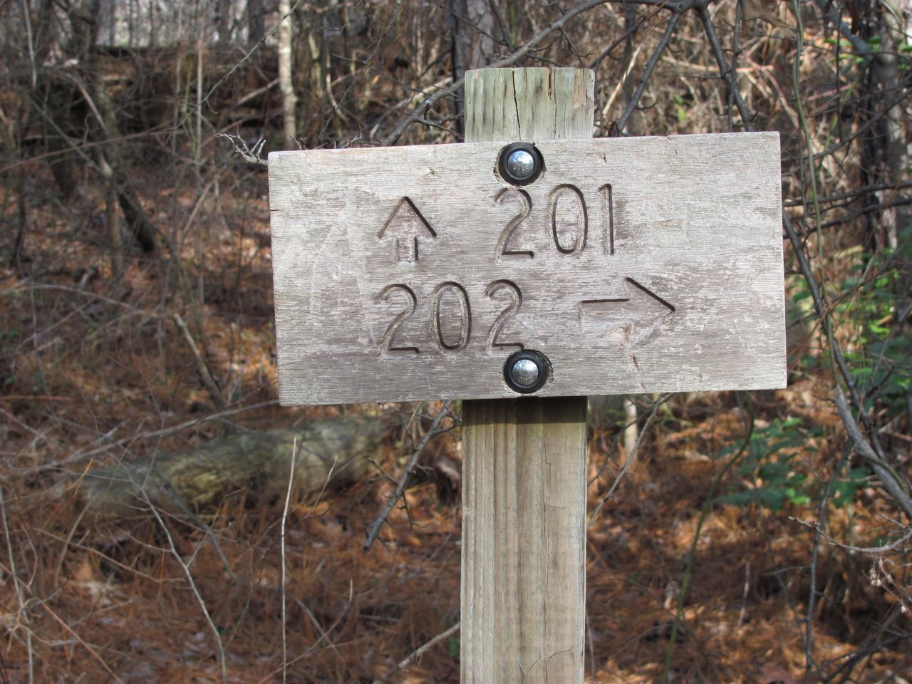
Our trail for today was 201, the Rippey Trail

By the way, we’re getting our trail information and description from the Sipsey Wilderness Hiking Club webpage.  Their trail descriptions have been very helpful.  Of course, we also carry that very detailed map we got at the sporting goods store.  I’m not sure where the trail names come from.  The Forest Services uses numbers on all their documents to identify the trails.  The map we got at the sporting good stores uses numbers to identify trails.  The Sipsey Wilderness Hiking Club uses these same numbers, but they also have names attached to those numbers.  Personally, I like trail names.

The 2.6-mile Rippey Trail starts at the Randolph Trailhead on CR 60.  This is a small parking lot with room for only about 8 cars.  Our map indicates it is a fee area, but there was no iron ranger or fee envelopes.  We hung our National Park pass in the window just to be on the safe side.  At the trailhead, there is a kiosk with a map and the trail just to the right.  There is a gated gravel road to the left.  The trail joins this road so it’s possible to hike the road instead of the trail for the first quarter mile or so.  We took the trail on our way out and the road on our way back.
Deciding where to go next.

The Rippey Trail was almost the opposite of what we did yesterday on the Borden Creek Trail.  The Borden Creek trail started down in the gorge and followed the creek for the entire length of the trail.  Today, on the Rippey Trail, we started on the ridge and stayed there for the entire length of the trail giving us a very nice woods walk.  We only passed one campsite today compared to the many we saw yesterday.  Although the terrain was relatively flat on the ridge, there was no water which would make overnight camping difficult.  The one campsite we saw was within 15 minutes of the trailhead; a short enough distance that a backpacker could carry in water.

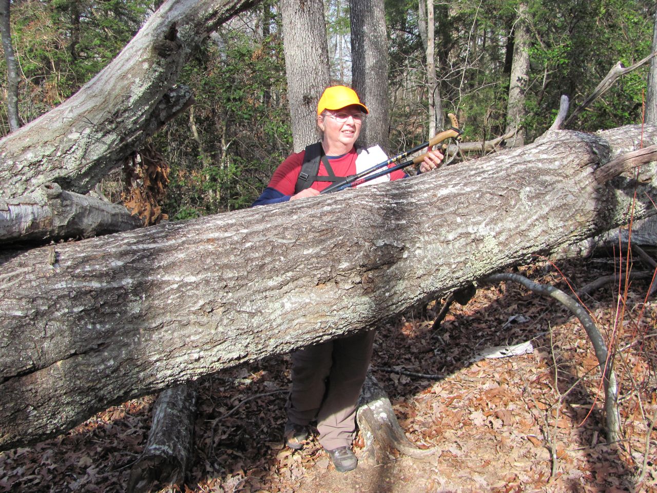
We were real glad the trail had been cleared through these blowdowns.
We saw a lot of blowdowns along this trail, but fortunately they had been cleared.  Technically, in a designated Wilderness area, blowdowns muct be cut with a hand saw or an axe.  No tool with a motor can be used.  We were very grateful for the hard work done to clear those trees.

This was a short, easy trail so we found ourselves at the junction with the Sipsey River and Thompson Creek trails after about an hour.  We weren’t ready to turn around just yet, so Gene studied the map to determine our best choice.  We decided to take the Thompson Creek trail off the ridge and down into the gorge.  Thompson Creek trail did not have its blowdowns cleared and we spent a considerable amount of time crawling over, under, and through fallen trees--a true wilderness experience.
I think I'm getting too old for this!

Thompson Creek trail is rated moderate and, besides the blowdowns to navigate, we also had a pretty steep descent down to the creek.  Once we were near the creek we started seeing campsites again and stopped at one for our lunch.  After a nice long break we turned around, headed up the bluff, through all those fallen trees, and back to the car.
Heading down into the gorge through a laurel thicket.

It was another beautiful day and a great hike.

Lunch at a campsite by the creek.
That’s all for now.  Thanks for tagging along.

Friday, December 2, 2011

Bankhead National Forest

The day got off to a frosty start, but quickly warmed up and turned out to be a beautiful day for a hike.  Although we were anxious to be on the trail again, we didn’t rush out the door at the crack of dawn.  We wanted to give those deer hunters plenty of time to do their thing before we got out there.
Sipsey River

We had about a 40 mile drive over to the Sipsey Wilderness area of Bankhead National Forest, named for U.S. Representative William Bankhead.  Bankhead covers some 181,000 acres and is Alabama’s largest National Forest. The Sipsey Wilderness is the largest wilderness area east of the Mississippi.  It also has the reputation of being Alabama’s most rugged hiking terrain with high limestone bluffs with drop offs into deep gorges.
Limestone bluff with a small cave at the base

On our way to the trailhead, we passed one of the Ranger Check In areas.  We pulled in there to see if we could get any more information about hunting restrictions or safety zones.  Boy, did we luck out.  Not only did they give us a map, but they also gave us a calender listing where the hunters could be on any given day.  The area we planned to hike in this week is on the West side of County Road 33 and the hunters are on the East side of the road today and tomorrow, then there’s no hunting all next week.  Wore our orange hats anyway since we saw a study which indicates 20% of Americans can’t read.

Our hike today was along the Borden Creek Trail within the Sipsey Wilderness.  As a designated “Wilderness”, there are no improvements to the trail such as foot bridges or stone steps like we would see in State or National Parks.  Neither is the trail blazed, but it is a well traveled path and easy to follow.
Borden Creek
The water was clear in Borden Creek with a sandy bottom; something we rarely see in Tennessee

The trailhead we used was at the Sipsey River Picnic area on Rt 6.  There is plenty of parking there and a standard government issue pit toilet.   There is a $3 fee to park, but we hung our National Park Annual Pass in our window and that works for National Forest, too.

There are actually two trails that start at this trailhead.  Sipsey River Trail and Borden Creek Trail follow the Sipsey River north for about a half mile to the point where Borden Creek empties into Sipsey River.  The Sipsey River Trail fords Borden Creek and continues northwest.  Our trail, Borden Creek Trail, makes a right turn and follows Borden Creek upstream for another 2 miles.
Honeycomb-like surface created by water seeping through the soft limestone

This was a very nice walk through hemlock forest with Borden Creek on one side and the bluffs on the other.  The trail information we had rated it as a moderate hike, but I would say it was easy walking.  What gave it the more difficult rating were the stream crossings.  We had to cross about five small feeder streams.  Because of the wilderness designation, there were no foot bridges and the slopes down to the streams were steep and slippery.  Each of these little streams was fed by a waterfall at the bluff face.  It has been so dry lately that these falls were nothing more than a trickle of water.  Spring would be a different story, I’m sure.

This is a popular area for backpackers and we passed several primitive campsites.  Most were small and would accommodate only a tent or perhaps two.  However, the campsite where we stopped for our lunch break was huge with plenty of room for 8 or 10 tents.  In fact, on our way out we met a large group heading to that campsite.  They weren’t packing light, either.  They seemed to have everything imaginable, including a large cooler.
One of many campsites we passed today

There was one major obstacle on this hike and I’ll have to admit I refused to go there.  Very near the northern end of the trail is a tunnel through the rock--very narrow and very dark.  It is only about 15 feet in length, but because it is “L” shaped, we couldn’t see the light at the other end.  I could not go in that hole.  The north side of the tunnel comes out behind one of those waterfalls.  We decided this was a pretty good place to turn around.
I couldn't go in that hole!

We had a great hike today and we’ll be back to Bankhead two or three more times this coming week.

That’s it for today.  Thanks for tagging along.