We left the Adirondacks and Lake Placid area this morning. Our next stop in New York is “the city”. However, one of the main reasons we want to go there is to visit with Gene’s nephews. Their schedules are pretty hectic so the best we could do was a couple weeks from now. When we started looking around for a campground within commuter train range of Manhattan, they were all full for the Labor Day weekend. So we find ourselves this evening on the far eastern side of Vermont in the town of Brattleboro.
We spent a month in Vermont a couple years ago, but we were up north near Montpellier. Since that time we have been wanting to see a little of southern Vermont. This is our chance. We are only a stones throw from Massachusetts and will probably get down there, as well.
I felt like we had a long hard day; Gene felt like we did okay. Now, there is a difference in perspective. You may be thinking I was sitting in the driver’s seat, but not today. We didn’t get a really early start. It was almost midnight by the time we got to bed last night after watching the Lord of the Rings movie. We couldn’t just jump out of bed to a running start. I wanted to sit in the chair and sip my coffee just one more minute. Then there was the drive. We always do a “map quest” for directions. We haven’t graduated yet to a GPS. It wouldn’t have mattered though. You just can’t get here from there. The problem is Lake Champlain. It is 12 miles across in places. There are no bridges. And there are no interstates. To get to Brattleboro from where we were in New York by interstate we would have had to go to Montreal and then taken provincial roads back to Vermont to pick up interstate or gone south somewhere in Massachusetts. Map quest put together a 168 mile route of several state and federal roads out of the Adirondack mountains south to a place we could cross Lake Champlain, over the Green Mountains, to, what I felt like it should be by the time we got here, the shores of Gilead. In reality, the roads were not that bad, certainly not as bad as some interstates we have driven on. However, when it is your house hitting the pot hole you feel every little ripple. Some of those roads were pretty narrow, some were steep in places, and curvy in the mountains. I was on the look out for every tree branch, mailbox, and welcome flag that hung out over the road. Our trip, which Map Quest promised to be a short 3 ½ hours, really lasted almost 6.
Thank you, Lord, that nothing was broken, we didn’t hit any of those cars parked on the side of the road, and we didn’t run into the back of that truck hauling a load of timber going 10 mph downhill. We arrived safely, albeit a little nerve frayed.
Tomorrow we will begin our exploration of southern Vermont.
Showing posts with label Adirondacks. Show all posts
Showing posts with label Adirondacks. Show all posts
Monday, August 25, 2008
Sunday, August 24, 2008
Happy Birthday, Gene
Monday is Gene’s birthday. Since we are going to be traveling on Monday, we decided to celebrate on Sunday. He thinks he’s old. In the scheme of things, he’s really not, just a mere 58. He is only 3 months older than I am, and I don’t think I’m old at all. He has had a pretty good day, I think, and he won’t really be old until tomorrow.
As is the case whenever we are moving to a new location, especially when we have been sitting for a month, there are several chores to do to prepare for moving. He started his special day by checking air pressure in tires and dumping waste water holding tanks. Next we went for our morning walk. Instead of walking around the campground, we walked about Wilmington for one last look around. By the time we got to our walk, the mountains were already shrouded in haze. Not a good morning for photos. I had promised to treat him to his mid morning coffee at Starbucks in Lake Placid. However, we had dilly dallied too much and were not ready to go to Lake Placid until after lunch. So instead of coffee, he got ice cream. As treats go, he’d rather have ice cream anyway.
We spent a little time in Lake Placid. There was a table runner I had my eye on, but finally decided I could live without it. Gene wanted to look in the antique store. That was kinda fun. We saw several things which reminded us of our childhood. I guess that is pretty appropriate to give you a real perspective on your birthday to see stuff you used as a child with a big price tag in an antique store.

For a special birthday dinner I fixed him some heart healthy salmon and a not so heart healthy chocolate cake. The cake decorating is not what you would call “professional”—I call it a “hand made, I did this just for you” type of decorating.
The perfect finish for this special day was the 3rd episode of Lord of the Rings on TNT. Happy birthday, Gene.
 |
| Mirror Lake in Lake Placid |
As is the case whenever we are moving to a new location, especially when we have been sitting for a month, there are several chores to do to prepare for moving. He started his special day by checking air pressure in tires and dumping waste water holding tanks. Next we went for our morning walk. Instead of walking around the campground, we walked about Wilmington for one last look around. By the time we got to our walk, the mountains were already shrouded in haze. Not a good morning for photos. I had promised to treat him to his mid morning coffee at Starbucks in Lake Placid. However, we had dilly dallied too much and were not ready to go to Lake Placid until after lunch. So instead of coffee, he got ice cream. As treats go, he’d rather have ice cream anyway.
 |
| Mirror Lake with Whiteface Mountain in the background |
We spent a little time in Lake Placid. There was a table runner I had my eye on, but finally decided I could live without it. Gene wanted to look in the antique store. That was kinda fun. We saw several things which reminded us of our childhood. I guess that is pretty appropriate to give you a real perspective on your birthday to see stuff you used as a child with a big price tag in an antique store.

For a special birthday dinner I fixed him some heart healthy salmon and a not so heart healthy chocolate cake. The cake decorating is not what you would call “professional”—I call it a “hand made, I did this just for you” type of decorating.
The perfect finish for this special day was the 3rd episode of Lord of the Rings on TNT. Happy birthday, Gene.
Saturday, August 23, 2008
A Chore Day
From time to time you just have to get the work done. Today was the day. I spent my day vacuuming, dusting, doing laundry and I even ironed a few things. I try not to iron. Generally, I can get by without that little chore in the summer, but it has been so cool this past week that we wore several long sleeved shirts and blue jeans. I saw advertized on TV last night a new product by one of the fabric softener manufactures that you spray on cloths and the wrinkles just fall out. I’ll have to investigate that. Sure would be nice to get rid of the ironing board and iron.
Gene busied himself with waxing the Montana. That is an ongoing project. He just does a little bit at a time—about an hours worth. I know as time passes the decals will fade and fiberglass will begin to look weathered, but for now it shines like a new penny. He works hard to keep it that way. Of course, it may cost us a pretty penny (or an arm and a leg, as the saying goes) to have his shoulder replaced—damaged by so much rubbing.
Together we have been cleaning out the refrigerator today. We are moving Monday so I wanted to get all those little bits and dabs of leftovers eaten. We had a fairly international lunch—Chinese BBQ on a hamburger bun with tortilla chips. Dinner was a variety of chicken (a leg, thigh, and a couple wings from a rotisserie chicken from the grocery, and half of a Greek seasoned chicken breast I didn’t eat last night), some taco seasoned beef, a serving of mashed potatoes, and mac and cheese. The second time around this stuff doesn’t sound too appetizing. But my mama taught me not to waste good food—something about all those starving children in third world countries. Maybe I could just mail it to them.
Tomorrow will be our last day here. We are going to Lake Placid for one last look around and to fill up on diesel fuel. I am sad to be leaving. Usually, by the end of the third week at any place, I am ready to move on. Not so here. But, alas, the Big Apple calls.
Friday, August 22, 2008
Mt Van Hoevenberg
 |
| Mt Van Hoevenberg |
We ventured up another mountain today. This one was a little shorter than the last one we tried to climb. The trail was a little shorter, also—only 2.2 miles one way.
 |
| A large beaver pond |
There are many trails to choose from within a short distance of our campground. We chose this trail to the top of Mt. Van Hoevenberg in honor of the man who started it all. Henry Van Hoevenberg was a lover of the great outdoors and he dedicated his life to helping provide opportunities for others to enjoy nature in this area. He was the first to map out a trail to the summit of Mt. Marcy in the 1880s. That trail which bears his name is the one we hiked on our trek to the top and it is the most popular route to Marcy’s summit because it is the shortest. Van Hoevenberg was also the builder of the original Adirondack Lodge (now spelt Loj) which was destroyed by a forest fire in 1903. He also founded the Adirondack Camp and Trail Club in 1910 to provide hiking opportunities to the early visitors coming to the Lake Placid area. Although the practice of marked trails with shelters coursing through the wilderness was not the brainstorm of Van Hoevenberg, he is credited with getting it started in this area.
 |
| Gene did a little work while we were there |
So today, in his honor, we climbed the mountain that bears his name. Except for the really wet stretch around the beaver pond, the trail was mostly dry and in good condition. It was a very enjoyable hike to the summit and a rock ledge provided a great lunch spot.
 |
| View from our lunch rock |
Thursday, August 21, 2008
Little Whiteface Mountain
 |
| Ski Runs on Whiteface Mountain |
Today we used the last activity on our “see it all” ticket. We rode the Gondola to the top of Little Whiteface Mountain. Whiteface and Little Whiteface are literally a maze of downhill ski runs with chairlifts shooting off in every direction. We climbed aboard and within minutes were deposited on top. The last little bit was pretty steep and Gene had visions of James Bond making a daring ski escape through the trees and around the gondola pylons. My vision was more along the lines of Bond crawling across the top of the gondola as it hung by a thread over the snowy slope hundreds of feet below. It was a slow day at the gondola so we had a car to ourselves. That was fun.
 |
| Ski Run map |
The view from the top was dramatic. We were below the summit of Whiteface so we didn’t have the big 360 degree view, but the high peaks region still dominated the horizon. From here we were able to see the ski runs on Whiteface mountain that were out of our line of sight from that higher summit. There was a nice wooden deck with picnic tables and a fantastic view of the Lake Placid. If I had known I would have taken a picnic.
 |
| Our Ride |


Also on the summit was a memorial plaque to the 10th Mountain Division. This specialized unit of the US Army was organized to with the help of the American Alpine Club and the National Ski Association to train soldiers and develop equipment for mountain warfare during World War II.
 |
| 10th Mountain Division plaque |

 |
| Whiteface and Little Whiteface |
Wednesday, August 20, 2008
Olympic Jumping Complex
 |
| Ski Jumps |
The Olympic Jumping Complex was included in the “see it all” ticket we purchased a couple weeks ago. The complex is opened every day, but on Wednesday and Saturday’s they have a jumping program which is included in the ticket. So naturally we saved that ticket for today to take in the program. The Jumping Complex is comprised of the 90-meter and 120-meter ski jump towers, a freestyle jump and a pool with kickers and trampolines where the freestyle skiers train during the summer months. Skiers are also able to train on the 90-meter jumping tower. The 120-meter tower is open for tourist inspection. That’s us.
 |
| Wet and Wild Skiers |
 |
| Learning twists and turns on a trampoline. |
We stopped first at the pool to take in the Wet and Wild Wednesday program. It was pretty impressive. There are Olympic athletes from the US and Russian ski teams in Lake Placid for summer training and they were the performers for today’s program. Some of the athletes had won medals at the 2006 games. I was pretty impressed. I had expected to see performers, not real athletes and certainly not Olympic athletes. Beginners use trampolines to perfect their twists and turns.
 |
| A perfect landing |
 |
| Going up |
After the program we stood in the long line to take the chairlift to the jumping towers. As we waited in line, we had the privilege of watching more Olympic athletes train on the 90-meter jump. That was cool, but they always got the next chair available on the chairlift. It was pretty weird to see skiers in the summer. At the 26 story high tower we took an elevator to the observation deck. Great views!! We got to go out onto the jumping platform and to the judge’s box. Now those are the seats to have.
 |
| View from the jump window |
 |
| Going Down |
Monday, August 18, 2008
The Rest of the Mount Marcy Story
This highpoint episode was very disappointing for me. This was like the culmination of several things recently which have pushed me to the inevitable—I’m getting older.
I have hiked many, many miles, climbed some pretty high mountains, and done some things that even shock me. Needless to say, I was devastated to have gotten so close and been too afraid to scramble over the rock to the top. Additionally, I was disappointed in my old feet. They are just not what they used to be.
Since noon Saturday, (the time when I realized I just couldn’t go up on that rock) my mind has struggled with the adjustment to another phase in my life. It hasn’t been pretty and Gene is to be commended for having lived through it so calmly.
My Uncle Carl actually got me started hiking. He considered it good therapy and, at a particularly difficult time in my life, he took me for my first hike. He made pimento cheese sandwiches for us and stuffed them into his day pack, we gathered up the dog and off we went. On the drive to the trail head the dog thought a nap was in order so he curled up on top of the pack to catch a few Zzzs before the hike. At lunch time, looking out over the wilderness from a rock high on a mountain, we laughed at the result of the dog’s pre-hike nap. The sandwiches looked like flat bread with yellow halos. It didn’t alter the taste; you just had to plan a strategy for getting bread and cheese in the same bite. My uncle has always been one for an adventure so when it came time to head down the mountain, he thought it would be fine to just leave the trail and go off down the hill side. I slipped after only a few steps and landed on my bottom. The dog thought that was a fine ride so he jumped in my lap. Down we went for about twenty yards before coming to rest somehow. My mother has always been one to be in the woods walking about, and a few years after this first hike, she persuaded me to join Tennessee Trails, our state hiking club.
So hiking has been my hobby for many years and I never gave a thought about the distance or difficulty of any trail. I think those days are over. A few years ago, while spending what seemed like days in the backcountry office at Rocky Mountain National Park trying to get permits to climb Long’s Peak, a seasonal ranger made a comment to the effect that he and his wife (both over 60) liked fixing a thermos of coffee, stopping by the bakery for Danish, and enjoying their goodies at one of the many waterfalls within 2 or 3 miles from the trailhead. At the time, I thought that was really hiking and we should do that more often. Perhaps now is the time.
I was encouraged by a couple things yesterday. We met a couple not too far from the summit as we were going down who seemed to be about our age. The gentleman commented that they were in the “hiking” rather than “climbing” phase of their life. I’m so there! I had email this morning from a long time hiking friend who, like me, never gave much thought to distance or difficulty. We have been on some pretty long hikes together including California’s Mt. Whitney. His email said that he and his wife had done a 14 mile hike and were pretty bushed the next day. Had to go shopping instead of hiking. Thank goodness I’m not the only one feeling my age here.
Still, aging is a difficult process and hard to get my mind around. It is one in which I will have to change my focus from long distance hiking (carrying everything on my back and sleeping on the ground) and climbing mountains to sipping coffee by a waterfall, bird watching, and taking long strolls in the park. This is actually starting to sound pretty good, after all.
Sunday, August 17, 2008
Mount Marcy
 |
| Mt Marcy through the trees |
The highest point in New York rises to 5,344 feet and dominates the High Points Region of Adirondack Park. There are 42 peaks that rise above 4,000 feet and are considered the “high” or major peaks in the Adirondacks. (Originally, there were 46 peaks listed as above 4,000 ft, but a more recent survey found 4 to be a tad shorter.)
 |
| Mt Marcy Information Center |
Compared to the high points of other states, Mt. Marcy is not really up there. It ranks as number 21 among the 50 highpoints. For a little perspective, Tennessee’s Clingman’s Dome is over 1,000 higher and the highest in the lower 48 is California’s Mt. Whitney soaring to 14,494. But 5,000 feet is nothing to scoff at. Clingman’s Dome is practically a drive up with a mere half mile paved walk to the summit from the parking lot. The shortest day hiking trail to Marcy’s summit is almost 7.5 miles one way which turns into a very long day.
 |
| All hikers must register |
Even though we normally think of tree line being somewhere around 12,000 feet in western parks of Colorado and California, we climb into the alpine zone on Marcy because we are at such a northern latitude. Going above tree line has its concerns, of course. The major concern is thunderstorms. I don’t want to be the tallest thing in the vicinity. We have had our eyes on the weather forecasts for the past 3 weeks waiting for a day we felt comfortable for our climb.
 |
| Marcy Dam |
Saturday looked like it would be our day, so we made all our preparations for an early start. Up at 4:30 we were able to get away from home by 5:30 and on the trail by 6:25. We were pleased with that. Our first break came at Marcy Dam at the 2.1 mile mark. We were there within an hour and again pleased with our progress. I was a bit surprised at the number of people at the dam. We were the 3rd party to register at the trailhead, but there were many, many people milling about. There are campsites and lean-tos in the area and apparently they were filled to capacity. We continued up the trail—up and up and up. There was some evidence of trial building which made this climb somewhat easier than Whiteface, but it was still very rocky, very steep, and very wet and muddy. Rock steps had been placed in a couple of the steepest sections and foot bridges had been built over some of the wettest areas.
 |
| View from Marcy Day |
We stopped for a short break about 10:30. When I turned to take a seat upon a rock, I saw the summit of Marcy for the first time. Just 1.2 miles away and another 1000 feet to climb. I also noticed dark clouds coming in. We were soon out of the tall trees and into short shrubs when the rain started. We elected to continue on because we were not yet to bare rock and there was no thunder, only rain. However, our climbing was hampered by still wetter rocks and the cumbersomeness of the ponchos. A few minutes later we heard the first clap of thunder, but the rain had pretty much quit. We continued on promising each other that if there was another clap of thunder we would turn around. It wasn’t long until we started seeing hail on the ground that had come down in the brief storm. Luckily, we had been just low enough to have had only rain.
As we left the low shrubs behind and climbed out onto the bare rock the trail became the trail that I hate. I can climb a steep trail as it makes its way over rocks, but I am terrified of a steep solid rock surface. I’m not afraid of heights; I’m afraid of falling, especially of falling when there is nothing to catch me for a few thousand feet. We sat down and waited for the storm to pass. When we felt it was safe, we started up, but I only got a few feet when panic set in. We were within 0.2 of a mile from the summit and I could not go up. At 12:25 we turned around.
The 7.3 miles down was grueling. There were literally hundreds of people on the mountain. There was always someone in the way or wanting by. I was hiking slower, so I always stepped aside to let folks pass. That cost us a lot of time during the course of the afternoon. Climbing up over the rocks is easier for me than going down. My legs are short and I often can’t reach the next step so I found myself sitting down and sliding to the rock or path below. With 200+ people and 4 dogs having passed this way, the bogs which didn’t seem too bad going up were quagmires on the return trip. The wood in some of the foot bridges was impossible to see for the mud. All this made for very slow going.
I had made a mistake at the beginning of the trip by not turning around when my foot started to hurt. I have a tendon, I think, on the top of my right foot that seems to get knotted up from time to time. This was the case today and I petted and pampered it, but after so many miles there was nothing I could do to keep it from hurting. Plus, after about 10 miles of rocks, the bottoms of my feet were so sore it was hard just to take a step.
After 14 and a half miles, 12 hours 25 minutes, we finally stumbled to the truck. We were two tired hikers and I would be happy to never hike again if I could only get my feet out of these boots.
 |
| Mt Mansfield, Vermont |
Since there are no Mt Marcy summit photos, I have included photos of some other highpoints done as day hikes.
 |
| Mt Washington, New Hampshire |
 |
| White Butte, North Dakota |
Friday, August 15, 2008
John Brown's Body
One of the reasons we find ourselves in the Adirondacks is because the highest point in New York is here—Mount Marcy. Some people collect stamps, others teapots, and others Carnival glass or old cars. I collect highpoints and Mt. Marcy will be number 20 for me. It is not really high in the scheme of things, but it is a long day hike above timberline and you just don’t go without some preparation. We will be starting our hike very early and we don’t want to waste any time trying to find the trailhead or run into any surprises on our way there. So we drove over to the High Peaks Information Center just to check out the distance and time from our campground to the parking lot, to check out the procedure for parking in a fee area when there is no attendant on duty, and to find the exact location of the trailhead. We got the information we wanted and on our way home, since we were so close, we stopped by to pay our respects to John Brown.
This was like a continuation of a story started a couple years ago when we were visiting Harper’s Ferry. It was at Harper’s Ferry, W. Virginia (Virginia at the time) that John Brown took his stand against the Federal Government. He, along with several others, went down to Harper’s Ferry and captured the federal arsenal along with a rifle factory. It was his idea to capture the arsenal and rifle factory to arm the slaves for their great uprising for freedom. Two men whose names you will surely recognize were detached to Harper’s Ferry to deal with Mr. Brown—Robert E. Lee and J.E.B. Stuart. Of course, there was a stand off which eventually ended in the demise of John Brown. In my humble opinion, Brown’s undoing was the result of the slaves (I’m sure to his great disappointment) failing to uprise. The ever hopeful John Brown hung around until he got himself hung.
Right here, just outside of Lake Placid is the farm of John Brown and it is here that his body “lies a mouldering in the grave”.
For a more accurate and complete picture of this famous raid you might want to visit the W. Virginia History Site at www.wvculture.org/History/jnobrown.html
 |
| John Brown's Farm House |
This was like a continuation of a story started a couple years ago when we were visiting Harper’s Ferry. It was at Harper’s Ferry, W. Virginia (Virginia at the time) that John Brown took his stand against the Federal Government. He, along with several others, went down to Harper’s Ferry and captured the federal arsenal along with a rifle factory. It was his idea to capture the arsenal and rifle factory to arm the slaves for their great uprising for freedom. Two men whose names you will surely recognize were detached to Harper’s Ferry to deal with Mr. Brown—Robert E. Lee and J.E.B. Stuart. Of course, there was a stand off which eventually ended in the demise of John Brown. In my humble opinion, Brown’s undoing was the result of the slaves (I’m sure to his great disappointment) failing to uprise. The ever hopeful John Brown hung around until he got himself hung.
 |
| John Brown's Grave |
 |
| Statue of John Brown |
Right here, just outside of Lake Placid is the farm of John Brown and it is here that his body “lies a mouldering in the grave”.
For a more accurate and complete picture of this famous raid you might want to visit the W. Virginia History Site at www.wvculture.org/History/jnobrown.html
Saturday, August 9, 2008
Whiteface Mountain
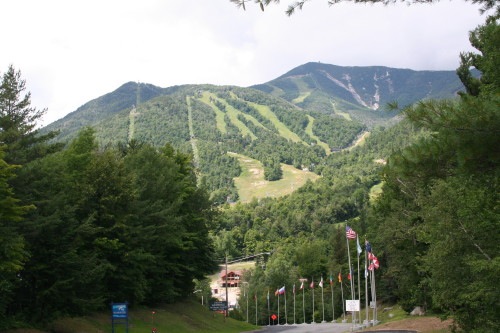 |
| Whiteface Mtn from Ski Resort at the base |
The sun came up on a big blue sky this morning so we threw our stuff in our packs and headed up the mountain. After our first attempt a week ago we had studied the map and guidebook in detail and decided an unmaintained and unmarked trail to Mt. Marble would get us up Whiteface in 2 less miles. Last week we had seen the trail intersection sign where the trail connects with the Wilmington Trail. The Mt. Marble trail essentially follows the old T-bar lift route from when this section of mountain was used for skiing. The trail was easy to follow (right up the stream bed) and we both agreed it was easier than the Wilmington Trail even though it was nearly as steep.
 |
| The trail up Whiteface Mountain |
Once on the Wilmington Trail, we climbed steeply and steadily for about a mile and a half. The trail leveled off for about a mile after that, but level was wet (almost as wet as last week when it was raining. I have decided they really don’t “build” trail here. They just route the trail through the stream bed, wet or dry it makes no difference, and then just tack up trail markers on the trees. There was one point in the trail where I think we actually crossed a pond. By the end of the day my boots were so wet and heavy with mud I felt like I was lifting club feet. Then came the steep pitch to the summit. Once on top, the view was spectacular. There were a few clouds, but we had good views of the high peaks region, Lake Champlain, and Vermont.
 |
| The summit as seen from the trial |
 |
| Parking lot for those driving up to the top |
Whiteface is the 5th highest peak in New York and it is a skier’s mecca. It’s not just world class, it is Olympic class with a 3,166 feet vertical run, the greatest this side of the Rockies. Whiteface stands alone a little north of the rest of the high peaks so the views from the top are fantastic. On a clear day, they say you can see Lake Champlain, Vermont, and all the way to Montreal. The Atmospheric Sciences Research Center maintains a summit building which houses some of their equipment. It has a great observation deck.
 |
| Atmospheric Sciences Research Bldg |
 |
| Great view of Lake Placid |
 |
| On the summit |
Opportunities for activity abound on the mountain. In addition to the ski runs there are hiking and mountain biking trails. Whiteface is the only high peak in the Adirondacks whose summit is accessible by car. The Whiteface Mountain Veterans Memorial Highway will get you almost to the top. Our special “see it all” tickets include this so we will wait for another sunny day and go to the top again.
 |
| Tram building and ski runs |
 |
| View from Mt Marble |
Monday, August 4, 2008
Backpacking in the Adirondacks
We had originally planned to hike up Mount Marcy, New York’s high point, as a backpacking trip. After studying the map and guidebook, we have decided to do it as a long, almost 15 mile, day hike. Since we don’t have plans for another overnight trip, and therefore wouldn’t have a personal experience to relate, I wanted to share what we learned about backpacking in the Adirondacks.
This is almost a perfect time of year for backpacking in the Adirondacks. The nights are cool and the days are pleasantly warm, but not hot. And it is past black fly season. There are regulations, of course, for backcountry camping. The New York State Department of Environmental Conservation manages Adirondack Park and, like their name implies, their job is to conserve and preserve this great wilderness area.
Generally, the guidelines are typical of those found at most National Park and National Forest areas. Camping is permitted anywhere so long as it is 150 feet from roads, trails, lakes, ponds, streams, etc. There are some designated camping areas adjacent to lakes and ponds. A permit is required for stays of longer than 3 days in any one area or for large groups. Pets are allowed, but they must be kept under control and their waste must be buried. Different rules apply for the High Peaks Region. There is no camping permitted above 4000 feet (above tree line) and camping between 3500 and 4000 feet is at designated camping areas only. Food must be stored in bear canisters during spring, summer, and fall in the High Peaks Region. There are lean-tos, or shelters, scattered about the park. These are available on a first-come, first-serve basis and they cannot be used exclusively by a single group.
In our hiking we have seen several lean-tos and several backcountry camp sites. The lean-tos are very similar to those 3-sides shelters along the Appalachian Trail. These have a peaked roof with very little overhang in the front. They are a log structure with a sleeping platform which will accommodate about 6. The ones we’ve seen have been very clean. There is a rule here that forbids the use of a tent inside the lean-to. I guess they saw me coming.
The designated camping areas we have seen vary widely. Some are very nice with large flat areas to pitch a tent on root-free, soft ground, covered with pine needles. Others have been rock and root littered on slops a goat couldn’t stand on.
While hiking, we always look around for a good camping spot. It’s an affliction we have that goes back many years. As we are hiking here we are again on the lookout for a great place to pitch a backpacking tent. Of course we haven’t done a lot of hiking here, but were we’ve been, we haven’t seen hardly any campsite we would consider suitable other than the designated camping sites. This may be due to the fact that we are hiking in or near the high peaks region and the trails are on steep mountainsides. Also, this has been an unusually wet season with rain just about everyday. The few areas that are flat enough for a campsite are too wet to use.
Still, this is a beautiful area for the backpacker with many lean-tos and designated camping areas provided just for your enjoyment.
 |
| A typical lean-to |
This is almost a perfect time of year for backpacking in the Adirondacks. The nights are cool and the days are pleasantly warm, but not hot. And it is past black fly season. There are regulations, of course, for backcountry camping. The New York State Department of Environmental Conservation manages Adirondack Park and, like their name implies, their job is to conserve and preserve this great wilderness area.
 |
| Campsite on Copperas Pond |
Generally, the guidelines are typical of those found at most National Park and National Forest areas. Camping is permitted anywhere so long as it is 150 feet from roads, trails, lakes, ponds, streams, etc. There are some designated camping areas adjacent to lakes and ponds. A permit is required for stays of longer than 3 days in any one area or for large groups. Pets are allowed, but they must be kept under control and their waste must be buried. Different rules apply for the High Peaks Region. There is no camping permitted above 4000 feet (above tree line) and camping between 3500 and 4000 feet is at designated camping areas only. Food must be stored in bear canisters during spring, summer, and fall in the High Peaks Region. There are lean-tos, or shelters, scattered about the park. These are available on a first-come, first-serve basis and they cannot be used exclusively by a single group.
 |
| Campsite on Owen Pond |
In our hiking we have seen several lean-tos and several backcountry camp sites. The lean-tos are very similar to those 3-sides shelters along the Appalachian Trail. These have a peaked roof with very little overhang in the front. They are a log structure with a sleeping platform which will accommodate about 6. The ones we’ve seen have been very clean. There is a rule here that forbids the use of a tent inside the lean-to. I guess they saw me coming.
The designated camping areas we have seen vary widely. Some are very nice with large flat areas to pitch a tent on root-free, soft ground, covered with pine needles. Others have been rock and root littered on slops a goat couldn’t stand on.
 |
| This is too rocky and not level enough for me. |
While hiking, we always look around for a good camping spot. It’s an affliction we have that goes back many years. As we are hiking here we are again on the lookout for a great place to pitch a backpacking tent. Of course we haven’t done a lot of hiking here, but were we’ve been, we haven’t seen hardly any campsite we would consider suitable other than the designated camping sites. This may be due to the fact that we are hiking in or near the high peaks region and the trails are on steep mountainsides. Also, this has been an unusually wet season with rain just about everyday. The few areas that are flat enough for a campsite are too wet to use.
Still, this is a beautiful area for the backpacker with many lean-tos and designated camping areas provided just for your enjoyment.
Tuesday, July 29, 2008
Hiking in the Adirondacks
We went for another hike again today. This time we took a short 2 mile one way hike which passed two ponds and ended at a third. At the first, Owen Pond, we saw a loon. He was so far away you can hardly tell what it is in the picture. I was so excited. That is the first loon we’ve seen since our trip to Maine a couple years ago. He was quite a surprise and my favorite part of the entire day. We stopped at the second and largest pond, Copperas, for a long break. I again sat on a rock at the waters edge to soak up the beauty of it all. We were somewhat disappointed with Winch Pond, where the short side trail ended. All the trees around the edge of the pond were dead. Many had fallen over into the water.
The trail was typical of what we are going to find in this area. There was ample parking at the trailhead and it was well marked at the road. There was a register at the trailhead for hikers to sign in and out. The trail was well marked with blue metal disc nailed to trees. These markers are higher on the tree than the blazes of most trails in the south. Many of these trails are used by for cross country skiing and snowmobiling; therefore, the trail marker must be higher to be above the snow pack. This is a wet environment and again we crossed bogs. If we were lucky there had been a foot bridge of sorts to cross on. More often, though, we just tried to find a rock to step on to stay out of the mud as much as possible. To avoid spreading the size of the bog, hikers are encouraged to walk through the bog rather than going around on the edge. Because of the dampness, rocks, roots, and fallen tree trunks are covered in moss. It is a lush, rain forest kind of place. The ground is kind of spongy, sort of like walking on peat, and there is always the smell of pine in the air. I just love it.


This is a very popular trail and we saw several people today. This could easily be made a loop hike of 3 miles if you used the road as a connector. There is parking at both trailhead locations. We chose not to do that because we wanted to go to the upper pond. However, if you started at the northern end you could be at Copperas Pond in just a half mile of very easy trail—great for families with children.
The park is managed by the New York State Department of Environmental Conservation (DEC). I am assuming they, along with the help of the Adirondack Mountain Club, and hundreds of volunteers maintain the trails. Whoever is responsible, they are doing an outstanding job. Hats off to the trail maintainers! Thank you.
 |
| Moss covered log |
 |
| A loon on Owen Pond |
 |
| Lean to on Copperas Pond |
The trail was typical of what we are going to find in this area. There was ample parking at the trailhead and it was well marked at the road. There was a register at the trailhead for hikers to sign in and out. The trail was well marked with blue metal disc nailed to trees. These markers are higher on the tree than the blazes of most trails in the south. Many of these trails are used by for cross country skiing and snowmobiling; therefore, the trail marker must be higher to be above the snow pack. This is a wet environment and again we crossed bogs. If we were lucky there had been a foot bridge of sorts to cross on. More often, though, we just tried to find a rock to step on to stay out of the mud as much as possible. To avoid spreading the size of the bog, hikers are encouraged to walk through the bog rather than going around on the edge. Because of the dampness, rocks, roots, and fallen tree trunks are covered in moss. It is a lush, rain forest kind of place. The ground is kind of spongy, sort of like walking on peat, and there is always the smell of pine in the air. I just love it.
 |
| Beaver dam |


This is a very popular trail and we saw several people today. This could easily be made a loop hike of 3 miles if you used the road as a connector. There is parking at both trailhead locations. We chose not to do that because we wanted to go to the upper pond. However, if you started at the northern end you could be at Copperas Pond in just a half mile of very easy trail—great for families with children.
 |
| A frog |
 |
| Blue bead lily |
 |
| Copperas Pond |
The park is managed by the New York State Department of Environmental Conservation (DEC). I am assuming they, along with the help of the Adirondack Mountain Club, and hundreds of volunteers maintain the trails. Whoever is responsible, they are doing an outstanding job. Hats off to the trail maintainers! Thank you.
 |
| View of Whiteface Mountain from Copperas Pond |
Subscribe to:
Posts (Atom)