Pages
▼
Wednesday, May 25, 2011
Rivers and Mountains
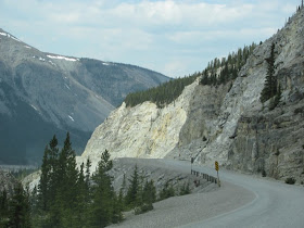
As we traveled west today the scenery changed from the rolling hills of timber to the mountains of the Central Canadian Rockies. Along with the mountains came the rivers.
This was a 200+ mile day and it seemed to take forever. We tried to get an early start, but also wanted to maximize our time with the internet. Reluctantly shutting down our computers, we finally pulled away from the campground about 8:30. By the time we got gas it was real close to 9 o’clock.
About 9:30, Gene remembered he hadn’t made a couple phone calls that needed to be made. Of course, by that time we were out of cell signal range. The search was on for a cell tower. We knew it wouldn’t be too long of a wait. The towers dot the landscape and they’re even listed in the Milepost. We found one within a half hour with a turnout conveniently located nearby. It even had a view. With the calls made and doctor bills paid, we were once again underway.
Have I mentioned cinnamon buns? I don’t think so. There are a couple things that have become very popular along the Alaska Highway. Cinnamon buns is one of them. The Milepost is full of advertisements for cinnamon buns. Signs along the highway entice motorists to indulge in the sweet treats. We passed a sign proclaiming the best cinnamon buns in “the galactic cluster”. We had to stop.
Like many of these family run businesses along the Alaska Highway, Tetsa River Services and Campground was a combination coffee shop, bakery, gas station, laundry, roadhouse, and campground. It looked like a real dump inside and out and all around, but the cinnamon buns may truly have been the best in the galactic cluster.
We stopped at Summit Pass for our lunch break. This is the highest point on the Alaska Highway at 4250 feet. Summit Lake is just below the pass and on the bank of the lake is a very nice provincial park campground. We were tempted to pull in and spend the night. I think we might have if the lake hadn’t still been frozen and there hadn’t been so much snow around. We opted to go down to warmer temperatures.
One of the most beautiful sections of our drive so far was the few miles along the edge of Muncho Lake. The lake is huge--7 miles long and 1 mile across and a beautiful blue-green color.
The road conditions slowed us down, as well. This was the first day to be stopped for road construction. We didn’t have to wait long, only a couple minutes. The road was rough for most of the drive today. Our overall average speed was only 41 miles per hour. Slow is good. We had more time to enjoy the scenery.
We finally arrived at Liard River Hot Springs Provincial Park. As soon as we got parked we headed for a soak in the hot pool. What a fine thing after a long day on the road.
GAS REPORT: At the Husky station in Fort Nelson we paid $5.57 for gas. This is calculated on an exchange rate of 2 percent. Surprisingly, diesel was the same price as gas.
Today we passed the 4000 mile mark for this trip and we’re still a long way from Alaska.
CRITTER COUNT: 4 moose, 2 cranes, 1 stone sheep, 4 buffalo, 1 caribou, and 1 bear
That’s all for now. Thanks for tagging along.


No comments:
Post a Comment