Friday, August 10, 2012

Pisgah National Forest


For a little change of scenery we loaded up the RV and are now parked at Mount Pisgah Campground on the Blue Ridge Parkway.  The Blue Ridge Parkway has 9 campgrounds along its 469 mile length.  Mount Pisgah Campground is located at mile 408 toward the southern terminus of the parkway and is across the street from Pisgah Inn.  This is typical of a federal campground--no hook-ups at the sites.  There is a central water spigot and a dump station.  We were totally surprised to find showers in two of the restrooms. Those two restrooms look like they are new or recently renovated.


There are only a few sites large enough to accommodate our RV so we waited until after many schools in the area started and waited until the weekend was over.  We arrived early in the afternoon and had no trouble getting a site.


The campground has four loops--two for tents, one for vans, small trailers, and pop-up campers, and 1 for larger RVs for a total of 128 sites.  Because the campground was nowhere near full, we were told we could park anywhere except in the tent only loops.  There are both back-in and half-moon pull-thru sites, all of which are paved.  Many sites are on such a slope that it would be difficult to get level, especially in the RV loop.  We had to move from the first site we chose just for that reason.  Most sites are too short for our rig.  There may be 10 or so sites that would be suitable for larger RVs.


Mount Pisgah is located in the 500,000 acre Pisgah National Forest in western North Carolina near Asheville.  There are about 400 miles of trail in Pisgah and these trails are commonly referred to as the “Pisgah 400”.  Do you suppose there are folks out there trying to hike all 400 miles?

We came here for the hiking, of course.  There are trails which lead from the campground to Mt. Pisgah Picnic area on the Blue Ridge Parkway and from there on to Mt. Pisgah Trail.  Can’t get much more convenient than that.  The Mountains to the Sea Trail is also nearby.


The campground is located across the street from Pisgah Inn which also has a restaurant and gift shop.  I’ve already bought something for our new home at the gift shop and started my Christmas shopping.  I expect we’ll be dining at the restaurant one night while we’re here since I forgot to bring the meat for one of our evening meals I had planned for this week.

Rooms with a view
And what a view
The elevation here is around 5,000 feet.  We were hoping to escape the heat at the lower elevations and we’ve not been disappointed.  The daytime temperatures have been between the mid 60s to low 70s.  The nights are cool enough that we’re too chilly with the windows open.  However, like is so common in the mountains, we have gotten rain every day so far.


It has been a nice change of scenery and the hiking has been good.  We’re happy campers.

That’s all for today.  Thanks for tagging along.

Tuesday, August 7, 2012

Trail Shelters


Whenever we wander by a shelter I usually make a picture then post it along with the story of that hike.  One of our faithful followers, Rick (Rick and Paulette’s RV Travels) usually makes a comment about the shelter.  The last shelter I mentioned in the blog was Mt Collins shelter in the Sugarland Mountain Trail post a few days ago.  Rick commented that he thought the shelters were a nice thing for hikers.

Thunder Hill Shelter in Virginia
You are absolutely right, Rick.  Most hikers really appreciate the shelters.  They’re certainly a welcome sight at the end of a long day, especially if it’s been raining.  Since Gene and I usually just stop in a shelter for lunch or a short break, I usually don’t say much about the shelters in a post.  So I thought I’d just share a few of my thoughts about trail shelters.

Trail Shelters are not the same as the “huts” in the High Sierras, Colorado, or the White Mountains.  Those huts are owned by Clubs or concessionaires and must be reserved and paid for to stay.  Trail shelters I’m talking about are structures along trails for overnight stays by hikers and usually require not reservations and are usually free.

Blood Mountain Shelter in Georgia
Trail shelters are not exclusive to the Smokies.  Although they can be found across the country, they are more common in the east and particularly along the Appalachian Trail.  Perhaps the model for the most common type of shelter was the “lean-to” found in the Adirondacks in New York.  Although we’ve seen many sizes and shapes of shelters constructed of various materials, by far the most common are the 3-sided log structures with a wooden sleeping platform, usually large enough to sleep six.  Often a second sleeping deck is added above making a “bunk bed” and doubling the sleeping capacity.  If you’re lucky, there’ll be a ladder to the upper bunk.

Deer Lick Twin Shelters in Pennsylvania, I think.
Gene and I don’t like to sleep in the shelters.  However, when on a long distance hike on the AT, we usually pitch our tent near the shelters.  The reason we don’t like to sleep in shelters, besides not wanting to sleep with 8 to 10 snoring strangers, is that shelters are rodent-ridden hovels.  The mice are bad enough, but I draw the line with the snakes that come for the mice.  Mice are definitely a problem; snakes not so much.  I’ve seen a few snakes at shelters, therefore, in my mind, they’re always there just lurking in the shadows waiting for me to fall asleep.

Tumbling Run twin shelters separate snorers and non snorers.
I especially like the clothesline in back.
The shelters offer some advantages when backpacking.  The main one, of course, is water.  Water is not just everywhere on the trail.  The shelters are built near a water source. The water still needs to be treated before drinking, but at least it’s usually easy to get.

Quarry Gap Shelter in Pennsylvania
Another advantage is often a picnic table or sitting log which makes cooking easier.  Many shelters along the AT now have cooking porches added which gives hikers a dry place to cook if it’s raining.  Cooking and eating in the sleeping area is a big “NO-NO” as food odors attract wildlife (bears).

Some may say the best advantage of being at the shelter is the camaraderie with other hikers.  It is nice to have company in the evening to swap tales of the trail.

Privy in 100 mile wilderness in Maine

I also like camping near the shelter because most have privies.  Personally, I hate digging a cat hole.

Icewater Springs Shelter in the Smokies
The shelters along the AT are the ones we’re most familiar with.  The AT Clubs have constructed shelters about 10-15 miles (one day’s walk) apart for the entire 2100 plus miles of the trail.  Some of these shelters are getting pretty old now.  Smoky Mountains Hiking Club maintains the AT through the National Park and in recent years renovated the shelters we’ve been stopping in on our day hikes.  They’ve added skylights, cooking porches, and replaced the roofs and sleeping platforms.   These shelters are very nice now.

Partnership shelter in Mt Rogers Recreation Area.  This one has a shower.
Along the AT it is permissible to pitch a tent in the vicinity of the shelter.  In some places there are even wooden tent platforms or gravel pads for tents.  There are some exceptions; however, and the Smokies is one of those exceptions.  The only time tents are allowed at shelters is during thru-hiker season and the shelter is full.  On our first section hike we were heading to Newfound Gap from Springer Mountain.  That meant 2 or 3 nights in shelters in the Smokies.  I worried from the time I got on the trail at Springer Mountain all the way to Fontana Lake at the edge of the Smokies about staying in a shelter with the mice and snakes.  I finally came up with the idea to sleep inside the tent body.  Gene used rope to attach the tent to the upper sleeping platform.  The tent wasn’t pitched inside the shelter and I wasn’t taking up any more space than I would have with just my sleeping pad. The best thing--nothing could crawl on me.

My nest safe from creepy crawlies
Here are a few pictures of shelters we’ve been privileged to pass by.  Some we’ve stayed near; some we’ve stayed in.

Ed Garvey Shelter
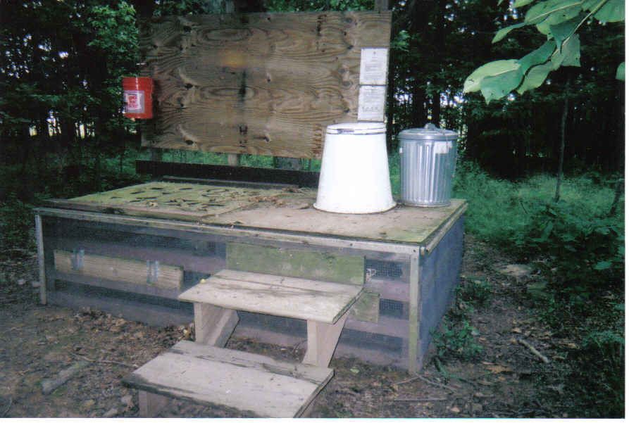
Privies are as varied as the shelters.  They range from the open air style (great views) to the new ones which must be handicap accessible.  We came across this new privy at the Matts Creek shelter in Virginia.  The trail crew (all volunteers and all senior citizens) were just putting on the finishing touches.  For privies built on federal land, handicap accessible regulations apply.  It doesn’t matter that the nearest road is 5 miles away.


That’s about all I know about shelters and it's probably way more than you ever wanted to know.  Thanks for tagging along.

Saturday, August 4, 2012

A Family Visit


My parents are visiting with us this weekend.  It was somewhat of a surprise.  Of course, they’re welcome anytime, but I didn’t think they were coming until September. I did get one day notice and was frantic on Thursday trying to prepare for company. They have come to Maryville, Townsend, Gatlinburg, Pigeon Forge, and Great Smoky Mountain National Park many, many times over the years, so nothing we did was new to them.  Still, it was fun to revisit all the familiar places again.


We spent the better part of one day driving around in the Park.  We weren’t very lucky with the views because of heavy cloud cover and threatening rain.  Everything around Clingmans Dome was in a shroud of cloud.  There were no views at all.  You never know what the weather will be like at the Dome, so if you’re in the Park, you take a chance and drive up hoping for a view.  When we got there, despite the threatening weather conditions, the parking lot was packed.  With no views to occupy our time, we did the next best thing--browse around the gift shop.  My parents are past the age where they are able to do much walking, so hiking the half mile to the observation tower was not on our list of things to do.


On our way back down the mountain, we stopped at Newfound Gap.  By the time we got there, the clouds had lifted some and we could actually see something besides fog.  This parking lot was nearly full, as well.  We’re looking forward to September when the vacation crowd thins out a bit.

We had our picnic lunch, of course.  My mother is the one who taught me to always take a picnic regardless of the weather.  So, with storm clouds brewing, I packed the picnic basket.  As we sat in the car at Chimneys Picnic area and ate our lunch and watched the rain, we discussed some of the more memorable picnics during my lifetime.  My dad and I both agreed it was a toss up between the ice storm somewhere in Georgia one year when we were on our way to Florida and the wind storm in Ontario the year we were going to Niagara Falls.

During the course of their visit, we also made a trip to Pigeon Forge.  As a rule, I try to avoid both Pigeon Forge and Gatlinburg.  These gateway communities to the Smokies are geared to the tourist and are just too crowded for my taste.  Besides, I’m not much of a shopper and I’d far rather have a picnic in the park than eat in a crowded, noisy restaurant.  However, my mother is a shopper and was delighted to just “stop by Pigeon Forge for a few minutes”.  We haven’t been to Pigeon Forge in a several years, and were surprised to find many of the outlet stores closed.  Gene asked about so many shops being out of business and the clerk told him that business has been going downhill for several years now and that this summer has been the worst so far.  Even though I don’t like to go there myself, that news was a little sad to hear.


We also went to Gatlinburg. I don’t like going there, but it’s because of the traffic.  I sorta enjoy just walking around sampling fudge, watching the people, and browsing some of the higher end shops.  Since the traffic is always so horrific, I usually try to avoid Gatlinburg at all costs.  Mother, however, wanted to eat at Bubba Gumps.  Gene and I have never eaten there so were anxious to check it out.  In our opinion, the shrimp was good, but not outstanding.  It was a fun place to eat, though, and we’ll probably take other guests there in the future.

We’ve also done plenty of sitting at home, drinking coffee, eating, and talking.  From the looks of my refrigerator we’ve got plenty of eating to do yet.  Needless to say, this has been a very busy weekend.

That’s my story for today.  Thanks for tagging along.

Thursday, August 2, 2012

Sugarland Mountain Trail


I think I’ve said before that we love the high elevation spruce fir forest in the Smokies.  Any of the trails accessible from Clingmans Dome Road are among our favorites.  The Appalachian Trail runs along the crest, but the numerous other trails that junction with the AT or with the road are also nice hikes.  Of course, all of these trails except for the AT are heading downhill which means (unless you’ve run a shuttle) the last half of your hike is an uphill climb.  Some things are just worth it.

Bear breakfast
Sugarland Mountain Trail runs for 12 miles from the Appalachian Trail near Mt. Collins Shelter down, down, down to the parking lot at Laurel Falls Trail on Little River Road.  If your knees can stand that much downhill, hiking through from top to bottom would be a real Smokies experience.  Starting at 6000 feet in the lush, wet rain forest zone and dropping down through every forest type to the bottom at 2300 feet would give the hiker a good sample of the entire park.  Not to mention some great views, a backcountry shelter and a campsite.  You’ve got it all in one hike.

We didn’t do that, however.  We started at the top and hiked down about three miles then turned around and hiked back up to the car.


The parking area on Clingmans Dome Road is at the Fork Ridge trailhead.  The parking area is really a couple of small pull outs which will accommodate about 6 cars.  There is a signpost almost directly across the street from the Fork Ridge Trail which directs you to the Appalachian Trail.  This short access trail goes right up to the AT where we turned left, or Southbound.  Sugarland Mountain Trail intersects the AT in two-tenths of a mile.


We had gotten an early start so were ready to start hiking by 8:30.  We were surprised to feel the nip in the air when we got out of the car at 6000 ft.  We could actually see our breath!  What a relief from the oppressive heat down below.  I love the early morning in the Smokies with the sun beams shining through the trees and the fog.


It was a treat to see trail blazes along the short distance we hiked on the AT.  The Appalachian Trail is the only trail inside the Park which is blazed.  It was comforting seeing those white rectangles guiding our way.

British Soldier moss.  I think it's really a lichen, not a moss.
A third of a mile down Sugarland Mountain Trail we passed a side trail to Mt. Collins Shelter.  We wanted to stop in there because it has been renovated since the last time we were here, but we could hear voices indicating the shelter was occupied at least by two people.  We decided to leave them in peace and save our visit for later.


Another tenth of a mile down the trail brought us to another side trail to a piped spring.  This is the water source for the shelter and it was flowing nicely after last night’s thunderstorms.  A tenth of a mile doesn’t sound like far, but carrying a couple quarts of water uphill can make it seem like a long way.


We continued our journey downhill.  Instead of hiking distance today we were hiking time.  After our long hike on Monday, we wanted something much shorter today.  We had determined that we would hike for two hours then turn around.


On our way back, we took the short side trail to Mt Collins Shelter.  This shelter, like the others in the Park, has been renovated.  The overnight guests had vacated the place and we had it all to ourselves.  We took a long lunch break here before hiking the last half mile to the car.

We found a large patch of these pink turtleheads
It was a short hike, especially compared to the drive to get to the trailhead, but oh so worth the effort.  The temperatures were cool, the sun bright in a beautiful blue sky, and the trail, though a little wet from last night’s rain, was delightful.  I could do this hike, or one like it, every day of the week.

That’s all for today.  Thanks for tagging along.

Tuesday, July 31, 2012

Gregory Ridge Trail


The ladies hiking extravaganza is now officially over.  With families and other commitments, the ladies came and went at various times during the month.  Sue hung on to the very end and she and Garnet spent the end of last week on a backpack out of Deep Creek.  We had invited them over for dinner Saturday night to celebrate a great month of hiking.  Sue and Garnet hiked every hike that was planned and logged right at 100 miles for the month.  They were both tired and hungry Saturday night, but spirits were high.

Gene was searching through the guidebook for a hike to do on Monday.  With the heat of summer it is hard to find something suitable that isn’t at high elevation.  When he came upon what the guidebook suggests as one of the finest hikes in the Smokies, how could we pass that up?

Gregory Ridge Trail is 5 miles in length and gains about 2500 feet.  Gregory Ridge Trail junctions with Gregory Bald Trail at Rich Gap.  At that point, it is only six-tenths of a mile from Gregory Bald via Gregory Bald Trail.  That was another 500 feet in elevation gain, but we were so close, what the heck.  We had to go up there.  Then there was a little side trail Gene wanted to explore which added at least another half mile to his day.  No wonder we were tired by the time we got back to the car.

Our trailhead is at the end of Forge Creek Road, a gravel road which is off the Cades Cove Loop Road.  The distance from our house is not all that great--only about 35 miles.  However, traffic on Cades Cove Loop Road was SLOW going and it seemed to take forever to get to the trailhead.


The first mile of the trail is almost flat through a beautiful hardwood forest with the sound of Forge Creek tumbling close by.  We crossed Forge Creek a total of three times.  The first two crossings were on footbridges.  At one time there had been a footbridge at the third crossing, but it has been washed away.  Remnants of the bridge could be seen down stream.


Just past this last creek crossing, we came to backcountry campsite 12.  If you were backpacking and forgot your stove, have no worries.  There was a collection of old cans suitable for alcohol stoves left at the campsite marker.  This campsite looked like it could accommodate 4-6 tents in its upper and lower sections. The upper section was much more appealing than the lower section.


After the third creek crossing the trail narrows and begins a more noticeable uphill grade.  For the next three miles it was a steady climb, but not horribly steep.  We plodded along, stopping for breaks occasionally and to take in what little views we could get through the trees.


Somewhere about a mile from the top is where we found the buck.  He was happy as a lark grazing in the middle of the trail.  He noticed us right away, but apparently felt we weren’t a threat.  He continued to nibble away at the grass along the edge of the trail until he slowing wandered off into the woods.  It’s always thrilling to see wildlife up close doing their wildlife thing.  This was the highlight of our day.


Gregory Ridge Trail ends at the junction with Gregory Bald Trail.  At the junction, Gregory Bald Trail goes left for 2 miles and ends at the Appalachian Trail or it goes right for six-tenths of a mile to Gregory Bald.  The Bald was our destination for lunch.


The views were not  outstanding off the Bald because of the haze, but we could see Cades Cove and we found a place to sit with that view for lunch.  The big draw for hikers to the Bald are the flame azalea in June.  Of course, that all gone now, but the blueberries were just coming on.  In another couple weeks we could probably fight the bears for a share.  At 5000 feet, the temperature was not uncomfortable on the Bald, but the sun was beaming down so we didn’t linger very long.  After about 20 minutes we were ready to find some shade.

If we had continued on Gregory Bald Trail and gone on over the Bald, we would have shortly come to the junction with Wolf Ridge Trail.  It is possible to make a loop hike using Gregory Bald, Wolf Ridge, Twentymile Loop and Long Hungry Ridge Trails and this was one of the backpacking trips the ladies had planned.  However, there has been severe storm damage along Wolf Ridge and Twentymile Loop Trails making them almost impassable.  Will save that for another time.


Gene is an old hiker and has been hiking the Smokies for many years.  In times past, there were more shelters in the backcountry than there are now.  He remembered there being a shelter somewhere between Gregory Bald and the trail junction at Rich Gap.  He wanted to find the site of that old shelter.  Luckily, there was a sign prohibiting horse travel on a very faint trail about halfway between the Bald and the trail junction.  He took a chance and followed that little used trail.  I stayed behind on the main trail.  It seemed a lot less snaky.  He found the site of the old shelter.  All evidence of the shelter was gone, but the piped spring was still there and flowing with water.

With lunch and the exploring done, we were ready to head back down the mountain.  The trip down was uneventful, but seemed like it was about twice as long as the uphill climb.  We stopped at campsite 12 for a break and were grateful for the more gentle grade of the last two miles.  The car was a welcome site, not only for it seat, but also for its air conditioning.

I’m not ready to declare this the finest hike in the Smokies, but it sure ranks up there close to the top.  We already have this hike on our list for winter.  It was obvious there are some incredible views from the trail if you didn’t have to look around the leaves.

That’s it for today.  Thanks for tagging along.

Sunday, July 29, 2012

Home Base


I think we’re pretty well settled into our little condo in Maryville, TN.  We have all our furniture bought, at least for the time being.  As we continue our travels, I’m sure I’ll be picking up what Gene calls “dust magnets” to sit atop the furniture or hang from the walls for a more homey feel.

We’ve been asked by family and friends if we’re going to sell the RV.  Our answer is a resounding “NO”.   We have no plans to give up RVing.  We’ve only scratched the surface of the fabulous places to visit.  We fully intend to spend at least 4 months each summer traveling.  Besides that, we hope to take a short trip each month or 6-weeks during the remainder of the year.

Unfortunately, we can’t park our RV in our driveway.  It is in storage at a campground near Maryville.  We have easy access for any regular monthly maintenance that needs to be done and it’s close at hand for a quick get-away anytime the travel bug bits.

It’s true--we’re no longer full-time RVers, but, just as so many folks who have been on the road for a number of years have said, change happens.  We were ready for what we think of as a “home base” and are glad we made the move.

We were talking with friends Tony and Diana the other day and Tony reminded me that I had not updated the blog to reflect our new lifestyle.  Thanks, Tony, for the reminder.  I’ve done that now and for more detail on some of the reasons for a “home base” and why we chose Maryville, Tennessee check out the Home Base tab under the header photo.

We already think of this place as “home”--both the condo and the community.  We feel like we have the best of both worlds now.  We’re looking forward to making friends and becoming involved with the Maryville community.  And, we excited about exploring America on extended trips during the summer and finding new hiking trails around East Tennessee, Western North Carolina, and North Georgia.

Life is good no matter where or what you call “home”.

Friday, July 27, 2012

Forney Ridge Trail


With the heat of summer, we keep looking for high elevation trails for our hiking adventures.  It seems we are always drawn to the trails off Clingmans Dome Road in the Smokies.  It was a toss-up between Forney Ridge and Forney Creek.  I voted for Forney Ridge because it was a little less steep and because it went over Andrews Bald.  We didn’t want to do the entire length of the trail down and back up again, so our plan was to hike down for as long as we wanted then turn around and CLIMB back up to the car.

Found this pink turtlehead at the beginning of our hike
Forney Ridge trailhead is at the end of Clingmans Dome Road.  There is a huge parking lot, but during summer months it fills up fast, particularly on a clear day.  We arrived about 9 AM and there were still plenty of spaces to park.


Forney Ridge is a popular trail as far as Andrews Bald.  Beyond the Bald, the trail is often deserted as are most of the trails in the Smokies even during the peak summer season.  It’s always amazing to me that we can spend a whole day on a hike and never see anyone.  Smoky Mountains is the most visited of all the National Parks, but most of those visitors never get off the pavement.  There are a few who venture down a trail to a waterfall or other feature, but rarely hike more than 3 miles from the road.  Even though the Smokies has millions of visitors each year, if you’re looking for solitude, this is the place to find it.

The 1.8 miles to Andrews Bald has been refurbished recently and is now a very fine trail.  We hiked this section earlier in the summer and I posted a couple photos of the trail in that blog entry.  The major draw for Andrews Bald are the azaleas which bloom in late June or early July.  That’s past now, so we saw very few people on this section of trail.  It offered for us just what we wanted--a cool place to hike.


We didn’t have azaleas to ooh and aah about, but there were a few flowers.  Most notably were the Turk’s Cap lilies.  I love to see these on the trail.


We also saw blue bead lily.  In the spring this has a yellow-green bell-shaped flower which is pretty, but I think I like the bright blue bead just as well.


There was also plenty Filmy Angelica.  It’s in the parsnip family and the bees seem to love it.  I kept my distance.

Since the bad storm a few weeks ago, we’ve noticed several blowdowns along the trails we’ve been hiking.  If we see something that needs attention, we don’t mind taking care of it so long as it’s not a major job.  Gene often carries a bow saw for this sort of light trail maintenance.  He didn’t have his saw on this hike, so got out the Swiss Army knife to cut back this dead branch that was hanging over the trail right at eye level.


The trail is a steady downhill from Clingmans Dome Road with just a slight uphill to Andrews Bald.  After crossing the Bald the trail drops steadily and continues to the junction with Springhouse Branch Trail.  We went down a little way, but not too far.  I think we were both thinking about that climb to get back to the car.  Also, it had rained recently and the trail was pretty wet.  A steep, wet trail required more work than what we were willing to give.  We went back to the Bald, spread out a poncho to sit on and just chilled out for a while.  Not a bad way to spend the day.


Forney Ridge Trail runs a total distance of 5.5 miles between Clingmans Dome Road and Springhouse Branch Trail.  It’s possible to make a loop hike combining Forney Ridge, Springhouse Branch, and Forney Creek Trails.  That’s about a 20 mile hike and not something I want to do in a day.  Luckily, there are several backcountry campsites along Forney Creek Trail making this a nice backpacking loop.

That’s it for today.  Thanks for tagging along.