Saturday, July 17, 2010

Weir Farm National Historical Site


Our destination today was far from trail related.  Today, we drove to Branchville, CT to visit the only National Park unit in the state--Weir Farm National Historical Site.


Even though the Park Service officially acquired the Weir Farm in 1990, the landowner had a lifetime lease so the property was not available for public use until 2005.  This small historic site commemorates the life and work of American artist Julian Alden Weir.  It is only the second Park Unit dedicated to the visual arts; Saint Gaudens in New Hampshire being the other.

The Secret Garden
Weir was born in 1852.  His father was an artist himself and taught drawing at West Point.  As a young artist, Weir studied the traditional classical method of painting and became an accomplished portrait and landscape artist.


His studio was in New York City and Weir wanted a get-away in the Adirondacks--a place where he could go hunting.  Instead, he traded a painting plus $10 for the 153 acres in Connecticut.  It was on this farm where he fell in love with the simple nature of the landscape that he was able develop his own style of Impressionism, what became known as American Impressionist.

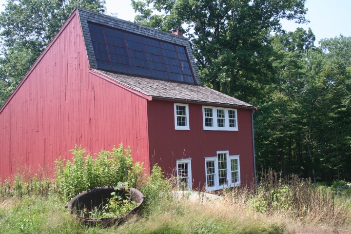
Young Home

Weir and his wife transformed the “farm” into a haven for friends and fellow artists.  Even today, artists still come to the Weir farm to draw inspiration from this rural Connecticut landscape.

Weir Home

Since Weir acquired the farm in 1882, it has remained in the hands of artists.  After Weir’s death, his daughter, Dorothy, inherited the farm.  She was an artist herself, but she was also married to sculptor, Mahonri Young.  In the 1950s, the farm was sold to New England painters Sperry and Doris Andrews.  It was largely through the efforts of the Andrews’ that Weir Farm is now a National Historic Site.  The Park service is continuing this artistic legacy with their Artist in Residency program.

Weir Studio
Since the Park Service acquired the farm so recently, most of the buildings are currently undergoing restoration.  The farm consists of only about 60 acres now, and includes the Weir home, his studio, the home of his daughter Dorothy, and Mahonri Young’s studio, the barn, gardens, and the Weir Pond.

Young Studio

Although it doesn’t look like it did in the late 1800s when the fields were open pasture and you could see Long Island Sound from the top of Nod Hill, it is still a wonderfully peaceful place to spend a few quiet moments in nature.

Friday, July 16, 2010

Mt Frissell, Connecticut High Point


Once again, what we ended up doing today was not what was planned.  It’s good to be flexible.

We started out the day with an adventure in route finding.  We had planned to hike the next section along the AT and got ourselves and our stuff loaded in the truck.  The directions were simple and we went straight to the parking lot where I was to start walking south.  However, in the small community of Falls Village, the bridge over US 7 was under construction.  Motorized vehicles were allowed to cross the now 1-lane bridge, but not hikers.  Also, along the way to the parking lot, Gene just happened to notice a detour sign posted where the AT crosses Warren Road.

In the parking lot, we got out all the information we had which wasn’t much since we don’t have the official ATC guidebook and map for Connecticut.  The information we have from trails.com is 10 years old.  The parking lot information was our best source, at least it was current.  What we badly needed was a map which we didn’t have at all.

The parking lot information indicated the trail had been rerouted due to the bridge construction and gave the names of the roads being used, but not where the detour started.  Without a map, we didn’t know where the roads were.  We drove back to the detour sign which was posted above a white blaze.  We knew that was the trail, so we decided to follow it and see what happened.  In about a mile we were out at the bridge construction.  We walked back to the detour sign.  We finally decided that this sign, which also gave the names of roads being used for the detour, was actually on the portion of trail that is temporarily closed.

One of the roads mentioned in both the parking lot information and on the detour sign was route 112.  We thought we knew where that was, so we got in the truck and headed that way.  Sure enough, we found a detour blaze.  We just kept driving on following all those orange and white blazes.  Finally, after about 3 miles down a couple country lanes, the detour blazes ended and the beloved white blaze appeared.


By this time, however, a couple of hours had passed and we were out of the notion for a 9-mile hike.  We found a place to turn around, we reviewed our options, and decided to check out Connecticut’s high point.  We were already pretty close, anyway.

Mt Frissell is in the far northwest corner of the state.  Well, actually the top of Mt Frissell is in Massachusetts.  The Connecticut state line runs along the south side of the mountain and the highest point along that line is Connecticut’s high point.  Connecticut is the only state where the high point is on the slope of the mountain.

The directions to the trailhead for the 1.2 mile hike to the high point were very clear and easy to follow.  The road, however, was something else.  First, we turned onto Mt Riga Road in Salisbury.  It quickly turned to gravel.  After 3 miles, we came to the junction with Mt Washington Road.  It, too, was gravel, but not as recently grated as Mt Riga Road.  We very slowly traveled the 3 miles to a small parking area just shy of the state line.

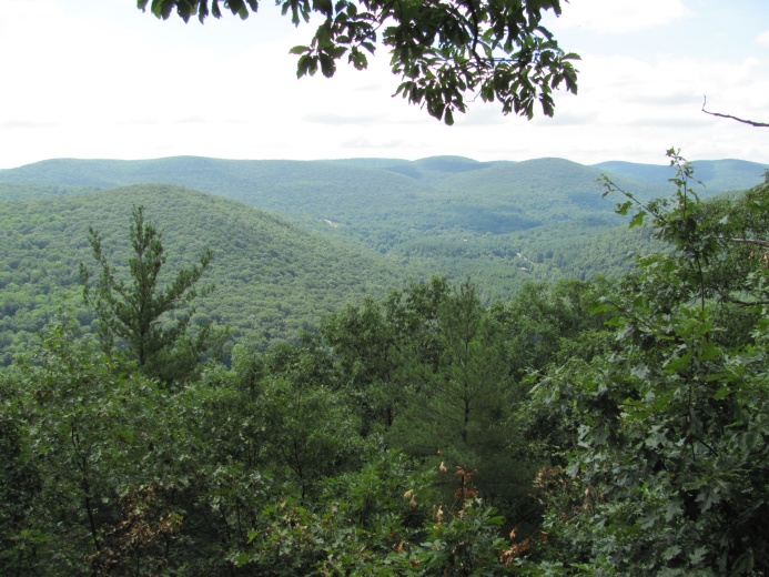
Looking toward New York

You would think there wouldn’t be anyone else around, but not true.  There were 2 cars parked at the trailhead, one car drove by on the road, the road grater from MA wanted to turn around in our parking area, and there was someone who stopped to ask us directions.  Unbelievable.

Much of the trail was through low shrubs on solid rock

We headed up the trail; and I do mean UP.  This was more a rock climb than a hike.  We finally made it to the top of Round Mountain and could see across to Mt. Frissell.  We descended slightly to cross the saddle between the two mountains.  The hike started out in MA and wove in and out between MA and CT so that when we finally reached the high point we were going downhill.


We made the photos, sat on the rock for a short break, then headed up and down, up and down to the truck.

I’m not saying what we have planned for tomorrow, because the plans are always changing.  We’ll see what tomorrow brings.

Connecticut state line marker

Til then.......

Thursday, July 15, 2010

River Road to West Cornwall Road


It felt good to be back on the trail again.  However, the good feeling wore off before we got to the end of the hike.


The hike was almost equally divided between 5.5 miles of flat and 5.5 miles of steep ascents followed by steep descents.  For me, the climbs came first as I was hiking south, as usual.  Sometimes, its hard to get out of the truck and immediately start a steep climb, but I’d far rather do that at the beginning of the hike than at the end when I’m dog tired.


I think the trail in Connecticut is pretty.  Sure, the climbs and descents are too steep.  I’d love to see a few switchbacks, but the forest is open and there are often good views from the tops of each of these climbs.  We had one great view today complete with a rock to sit on and enjoy a short break.  There were other views, but they required walking on side trails to the edge.  I’m not one to go out of my way, especially if it’s to a view I’ve already seen.


I felt like I was back on the roller coaster with all the ups and downs.  I finally ran into Gene about halfway up the last climb.  We found a rock to sit on and took a long lunch break.


My second half of the hike was down right easy.  After I got down to the river, the trail followed an old road bed along the west bank of the Housatonic for about 4 miles.  Then the trail followed the gravel River Road all the way to the truck.  The trail description from Trails.com claims this is the longest flat stretch of trail on the AT.  I don’t know if that’s true or not, but it sure was a relief after the earlier workout.  I was almost too tired to enjoy this stretch and I felt sorry for Gene having all those ups and downs at the end of a long day.

I think that’s all I know for today or at least it’s all I have the energy to write about.

Wednesday, July 14, 2010

War on Fleas


Holy cow, if it’s not one thing, it’s another.  I suppose that keeps us from getting bored our set in a routine.  Today, the issue is fleas.

I’m not sure how we got fleas, but fleas we have.  I don’t think you would call it an infestation.  I haven’t seen any myself, but Gene has found two and Peanut seems to be scratching and gnawing at himself more that usual.

Peanut is an indoor cat.  He gets to go outside when we carry him from the Everest to the truck on travel days.  On rare occasions, when we’ve left the door open to bring in groceries, he’ll slip out and down the steps, but he very rarely gets to the ground before he’s captured.  If he didn’t bring a flea in on one of his sojourns outside, then that leaves us as the culprits.

I really don’t know if fleas will ride along on shoes or socks.  We have read in some of the trail journals of thru-hikers this year, that some of the shelters have fleas infestations.  Perhaps we’ve brought back a few fleas from the trail.  Still, that seems very unlikely.

I just don’t know how we got this problem, but it has to be dealt with.  So instead of hiking today as planned, we drove over to Torrington to PetCo to arm ourselves with the ammunition for our war on fleas.  We got a 4-month supply of an ointment to squeeze on the back of his neck that is supposed to kill fleas, flea eggs, and larvae with the added bonus of killing deer ticks.  We also got an aerosol to spray on the carpets.

In addition to treating Peanut and the carpets, I’ve wash all the blankets, afghans, and vacuumed the carpets, floors, chairs, and sofa.  Then I tossed the vacuum bag in the trash.  I hope we’ve won the war on the fleas.

Going to Torrington gave us the opportunity to pick up a box of Peanut’s cat food at Walmart which they don’t carry at the local grocery in Thomaston.  It was time to get my prescription refilled as well.  We got a lot done in that one trip.  And PetCo was right next door to Walmart.

We were also able to take care of the truck and rental car issue today also.  The truck was ready for pick up late this afternoon.  Enterprise was happy to pick up the rental car at the Ford dealership so we didn’t have to take the car to Torrington.  In this age of electronics, Gene can take care of the charges for the rental car via the internet.  Super.

Now that this latest crisis is taken care of, maybe we can get back to our hiking.  We’ll see what tomorrow brings.

Tuesday, July 13, 2010

Hartford, Capitol of Connecticut


A nice, long hike did not turn out to be in the plan for today after all.  We decided sometime last evening to drive over to Hartford to tour the capitol building.  It’s been on our “to do” list since we got here.  I’m not sure why we decided to ditch the hike and go touring instead.  Maybe we just needed to do something different today.  Maybe we just wanted to take advantage of the easy maneuverability of a small car while we had the opportunity.


Our primary goal was the capitol, but within a mile were the homes of Harriet Beecher Stowe and Samuel Clemens, aka Mark Twain.  There are also three different Volksmarches in the city, all beginning at the Holiday Inn across the street from the capitol.  Since the Volksmarches include maps, we made that our first stop.

Genius of Connecticut.  She used to be on the dome.

We parked in a public lot a half block from the Holiday Inn.  If we had known, there was a small visitor lot at the capitol which would have been free.  Instead, we paid ten dollars to park.  Oh, well.


After we picked up the map, we headed out to the Stowe Center and Mark Twain Museum.  Along the mile or so walk, we passed the Cathedral of St. Joseph.  It was a massive structure.  We also passed The Hartford Insurance Company.  That was also a massive complex.


We reached the Stowe Center first.  We did not take the tour of the house, but perused the small exhibit, watched the short film, and wandered around the gift shop and grounds. Next door to Harriet Beecher Stowe’s house is the home of her grandniece, Katharine Seymour Day.

Katharine Seymour Day Home

Behind these two fine homes at the Stowe Center is the mansion of Samuel Clemens, much better known as Mark Twain.  Again, we didn’t take the tour, but visited the museum and wandered about the grounds.


We backtracked to where we had started and headed over to the Capitol.  The huge building was built in 1876 and is the only Victorian Gothic style state house in America.  We picked up the self-guided tour brochure and wandered around the two floors which were open to the public.  We just happened to be near the representatives’ chamber when a small school group was there on tour and we got to go inside the chamber with them.  Otherwise, we would have missed this as both chambers are usually locked.  The Capitol is quite impressive from the outside, but seemed rather small inside.  Perhaps it was because of the large amount of space taken by the central staircases.  That left rather small areas all around.  It was very ornate on the inside, typical of the Victorian style.

Mark Twain quilt

Located very near the capitol on Trinity Street is the Soldiers and Sailors Memorial Arch built in honor of Connecticut’s Civil War veterans.   Built in 1885, it was the first triumphal arch in America.

We enjoyed our touring, but it was really too hot and humid to be very pleasant walking along asphalt and concrete next to traffic.  The air conditioned buildings were a welcome relief from the heat.  I’m glad we opted not to do one of the 6-mile volksmarches.  Just as we got in the car, it started to rain.  We are blessed, indeed.

Our nice long hike is back on the agenda for tomorrow.

That’s all for today.

Monday, July 12, 2010

Truck Repairs


That time has come again--the time to take the truck for service.  It seems like it rolls around all too often.  Then again, being in travel mode twelve months a year, we put a lot of miles on the truck.

Gene drove over to Litchfield this morning to the Ford dealership.  About mid-morning the phone rang and when I answered he said he had “bad news and bad news”.  Now, I’m no expert on truck stuff, but this didn’t sound good.  I asked for the bad news first and indeed it was bad news--there is a leak in the fuel tank.  I really couldn’t think of anything to say so he went on with the bad news.  There is also an exhaust leak where the pipe (or whatever gizmo) comes out of (or is attached to) the engine.  Again, I couldn’t quite think of anything to say so he went on with the bad news.  Apparently, our truck is just riddled with holes because there is an oil leak at the base of the engine.  He came home a couple hours later after renting a car from Enterprise.

The good news is we get to drive a little car for a few days while the truck is repaired and our bank account is drained.  Speaking of draining things, I wonder what will happen to that almost full tank of diesel fuel.

There really is some good news in all this--all the engine stuff is still under warranty.  To fix the oil leak the engine has to be dropped and, naturally, all the oil drained so we won’t have to pay for the oil change.  Still, with the new fuel tank and the other 90,000 mile scheduled maintenance items, we get to cough up well over $2,000.  That’s plenty, thank you.

This evening we’re recovering from the shock.  Tomorrow, we’ll go for a nice, long hike to get the blood flowing again.

Sunday, July 11, 2010

St Johns Ledges


Well, our hike today was different.  We did a loop with a partial road walk instead of a linear hike.  It all started with our discussion of St. Johns Ledges.

An active hornet's next hanging right next to the trail

Since we don’t have a guidebook for this section, we’re almost flying by the seat of our pants.  Gene subscribes to Trails.com and was able to find a trail description and map for a few of the sections of AT in Connecticut.  When we read the description from Trails.com about today’s section of the AT, we were apprehensive about the quarter mile section called St. Johns Ledges.  We each did Google searches, but everything we found only fueled our apprehension.  One hiker journal entry even showed a picture of a snake he saw.  By the time we went to bed last night we were almost afraid of crossing the “ledges”.  I certainly didn’t want to try it alone and, if I hiked south as usual, it would be uphill.

For Gene, I was concerned about crossing the “300 feet along the edge” just before the descent of the ledges.  Gene has a fear of vast open spaces with nothing below him but air.  I could envision a 300 foot long 8 inch wide stretch of trail at the edge of rock face.  We had already read how the Ledges are a very popular place for rock climbers.  I wasn’t too thrilled about getting across the edge myself.


For myself, I was more concerned about getting up the Ledges.  Several descriptions we read indicated hikers just scooted down on their butts.  One description said, “Gravity is your friend”.  I knew I couldn’t very well scoot up a rock.

In the end, after all the research, we decided to hike together.  Luckily, there was a gravel road at the base of the ledges which we could walk out on to our truck parked on CT 341 in Kent.  This would not have been our first choice, but we felt it was our best option to be safe in case either one of us had a problem.

As it turned out, the ledges were steep, but there wasn’t a place where I would not have been able to climb over.  There was no 300 foot long edge to cross.  So it was not nearly as bad as we had created in our minds.


We started our hike by crossing a stile into a cow pasture.  No cows were out today, so nothing to worry about there.  I’m not real fond of stiles, but this one was fine.  I didn’t have to put my hands on anything.  I hate those stiles in southern Virginia that are more like ladders.  I always think of the thousands of hikers who have walked through cow piles, then up and over the stile before me.  Makes me want to wear rubber gloves.


After the cow pasture, we had a steep climb up the mountain and then a pleasant walk across the ridge in open forest.  One place got close enough to the edge for a good view.  It was a little hazy, but not too bad.  The best views were at Caleb’s Peak.  This was the last good spot for a break before the dreaded “Ledges” so we sat on a rock, ate a snack, and enjoyed the view.


It took us a while to descend the Ledges, but we took our time and all went well.  We met another group going up as we were going down.  They graciously stepped to the side to let us come by.  I turned back to see where they were on the rock and to make a photo.  I was surprised to find them almost directly overhead.


We finally got down to the river and the gravel road.  We had a 3-mile walk back to the truck from there.  That went fast and was mostly shaded, so not so bad.

The truck is due for service, so we’ll not be hiking tomorrow.  The Ford dealership is in Litchfield.  We’ve driven through there several times on the way to the trail.  It looks like a very nice community.  I haven’t decided if I’ll tag along to do a tour of the town or just stay home and rest.

That’s it for today.