Pages

Saturday, July 31, 2010

A Waterfalls Hike


We have another day of almost perfect weather.  It was a little chilly when we got up this morning with temps in the low 50s.  At least that is what our thermometer read.  The weather forecast said 45.  All I know is it was cool enough inside to turn on the fireplace.    By 9 AM it was very pleasant outside and has remained in the low 70s for the rest of the day.

Gordon Falls

We did another short, easy hike this morning.  We wanted waterfalls today, so Gene selected Fallsway which follows Snyder Brook upstream past 3 waterfalls in less than a mile.  The trailhead is located at a large parking lot which serves several trails to Mt Madison and Mt Adams.  Since the weather was almost perfect for a high peaks hike, the parking lot was full and running over.  We turned around and came back a mile to a small lot and walked that extra mile along the greenway.  It worked out just fine.

Snyder Brook

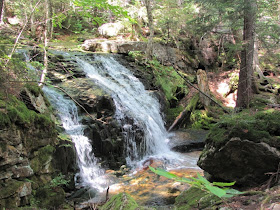
We hiked up Fallsway trail along the west bank of Snyder Brook past Gordon, Lower and Upper Salroc, and Tama Falls.  There was plenty of water in the brook, but not nearly as much as in the spring and early summer.  Still, all the falls were running pretty good, except the Lower Salroc.

Tama Falls

We were glad for the low water level when we had to cross Snyder Brook for our return hike along the east bank--Brookbank Trail.

Upper Salroc Falls

We strolled along taking our time and making photos, but we were still back at the truck shortly after noon.

As we passed through downtown Gorham, we spotted a couple thru-hikers.  We picked up Boston and Moonpie for a ride to Pinkham Notch.  At Pinkham Notch, Kiwi was looking for a ride to Gorham, so we brought him back to town.  Glad we were able to help these hikers out.  I’m especially glad to have met Kiwi.  He’s getting off the trail here.  He has lymes disease and will not be able to finish the trial before he must return to New Zealand.

A few places along the creeks were better than the falls

We finally got home for lunch and are going to take it easy for the rest of the day.

Friday, July 30, 2010

Pine Mountain


Boy, were we ever lazy hikers today.  When Gene asked me what I wanted to do today, I said an easy hike.  I think he may have found the easiest hike in the White Mountains.

Our trail for today
On top of Pine Mountain is a church camp.  Although the road is closed to the public, they invite hikers to stroll on up the hill.  The reason anyone would want to go up there is for the magnificent view from “pulpit rock”.


So we pulled on our hiking boots, stuffed a ham and cheese sandwich in our packs, and we were off.  It was definitely an easy hike up a gentle grade to Horton Center, the church camp.  There was no traffic on the road so I was a little surprised to find people at the camp--a lot of people.  I shouldn’t have been surprised; after all it is summer and where do kids go in summer.

Main building at Horton Center
We found our way out to pulpit rock and the view was indeed magnificent.  We sat on the rock admiring the view and trying to pick out the mountains around using our topo map.  After about 20 minutes, a small group of kids with their leader came up for an activity.  We had to leave.  Oh well, it was a great spot, even for a little while.

A short walk up and a short walk back to the truck and we were home by early afternoon.  Now that’s pretty lazy hiking.

Thursday, July 29, 2010

Gorham, New Hampshire


Well, we are still a little sore from our trek up Mt Adams, so we didn’t want to put on heavy boots and climb over rocks today.  Neither did we want to sit in the house.  Soooo, we drove over to the small town of Berlin to see what it was all about.

Glen Ellis Falls 64 feet
Berlin has a population of a few thousand more than Gorham and I was hoping for a large supermarket and a historic downtown.  I was very disappointed.  Of all the small towns we’ve seen in our travels around America, I don’t believe I’ve seen one as depressing as Berlin.

Russian Orthodox Church in Berlin

Every building and nearly every home needed some tender loving care.  Lawns were overgrown, paint was peeling, signs were missing, and windows were boarded up.  It was so sad.  If there was a central old downtown area, we couldn’t find it.  There were only two bright spots in the desolation.  We saw a couple very small city parks, one on each side of the river.  The grass was mowed and flowers were planted.  The other bright spot was the Orthodox Church sitting high on the hill almost out of town.

Public Library
Back in Gorham, we stopped at the Visitor Center for information on the greenway trail.  It’s an old railroad bed that has been converted to a bike and hiking path.  We had seen it a few times and wanted to know where the parking areas were located.  The little volunteer, bless her heart, she tried, but she really didn’t know anything about the rail trail.

The old train depot is now a museum
We had noticed what looked like the Town Hall, but there was nothing on or around the building to indicate that’s what it really was.  The only thing on the building was a Masonic Lodge symbol.  We refused to believe that wasn’t the Town Hall; there were just too many cars parked around including a couple police cars.  So we asked the sweet little lady in the Visitor Center.  Yes, that was the Town Hall, but she didn’t know why there was a Masonic Lodge symbol on the front.  She suggested we go ask, so we did.

Gorham Town Hall and Masonic Lodge

We marched right in the front door and went in the first office we came to.  The nice lady there knew all about the Masonic Lodge.  The Masons had owned the property originally.  They had constructed two lodges, both were destroyed by fire.  They didn’t want to build another lodge themselves, so they offered the property to the city for a dollar with the stipulation that they could meet in the building.  That was fine by the city--they got the land for cheap plus the Masons helped to build the building.  This fine old building is currently undergoing renovation, but the third floor where the lodge meets is completed, so she took us up for a tour.  How great was that.

Gorham is a tiny town of only about 3,000.  It sits in the Mt Washington Valley right against the White Mountains.  It’s a laid back tourist town, catering primarily to the hikers who come to hike in the Whites.  There are a couple B & Bs and a few modest motels.  There’s a McDonalds, Burger King, KFC, and a Pizza Hut along with a few locally owned small eateries, mostly Italian or pizza places.  Nothing fancy, nothing you can’t wear hiking boots into.

We were home for lunch, but still didn’t just want to sit around, so drove down to Ellis Glen Falls.  We managed the very short walk from the truck to the falls and back again.  We also stopped at Pinkham Notch to look at their relief map.  It is nice to actually see how steep the trails are, but I think they should glue little “boulders” to the map to give a more accurate impression.


We also saw the World Guy again today.  We saw him a few days ago walking down route 16 with his world on a chain.  We stopped and asked him what’s up with the world.  He seemed like a very nice man.  He’s walking from Washington DC to Maine for diabetes awareness.  That’s great.  His son and dog were also walking with him.  We checked out his website, worldguy.org.

That’s been our adventure for today.  We may hit the trail again tomorrow.

Wednesday, July 28, 2010

Mt. Adams


Hiking Mt Adams has been on our radar since we got here.  However, being above timberline, we had to wait for the weather forecast at the higher elevations to be safe for our hike.  Yesterday was the day.  The forecast was for clear skies with the peaks in and out of cloud, no rain, temperatures 40-60, and winds around 30 mph.  About the best weather conditions we could hope for.

There are about a zillion trails that go to the summit.  We studied the guidebook and read every description, finally settling on Lowe’s Path.  Lowe’s was not the shortest trail, but was only seven-tenths of a mile longer than the shortest.  We chose Lowe’s because the description repeatedly used the terms “moderate grades” and “good footing”.   Neither was anything thing said like knife-edge, ledges, or rock scrambles.  The thing that really caught our attention was “this is the easiest route to Mt Adams.”  The contour lines on the map were farther apart than on any of the other trails, so Lowe’s it was.

We got an early start and were at the trailhead at 7:50; better than we expected.  The first couple miles, although a gain of about a 1000 feet, was gentle and generally a dirt path without so many rocks.  We got to the first trail junction at 1.7 miles and took a nice break.  While we were sitting there, a gentleman came along.  During our brief conversation with him, we learned he was trying to hike all the peaks in the Whites which rise above 4000 feet (a total of 48).  Adams 4 and Adams would be his 42nd and 43rd.  I’m going to refer to that guy as Peak-bagger.  He would appear again as the day wore on.


From this point, the trail got much steeper and rockier.  Bless the trail crews.  They have put in rock steps where possible and we were truly grateful for that effort, especially on our way down.  We gained almost the same amount of elevation in the next seven-tenth mile and we were ready for another break at the Log Cabin.


The Log Cabin is a shelter very similar to other shelters we’ve seen up and down the Appalachian Mountain chain.  Instead of a 3-sided structure, it was nearly closed in on the front side with only a wide opening for an entrance.  Without the sky lights which are often installed in the newer and/or renovated shelters, the Log Cabin was dark and dreary inside.


We continued our climb all the way to timberline before our next break.  It was only eight-tenths of a mile, but it took forever.  Twelve hundred feet almost straight up, every step on or over a rock.  At 11:30 we popped out of the trees.  It was a good spot for a break with magnificent views and a good idea of how much 3000 feet is.

We felt pretty good about ourselves at that point.  We only had a mile and a half to go with 1500 feet of climb.  We could see what we thought was Mt Adams and it didn’t look too bad.  Besides, the really steep part was behind us now.  We took a few photos, ate a snack, and got ready to leave.

We had taken about three steps when Peak-bagger came up from the trail which led to Gray Knob Cabin.  He had chosen to take his break over there.  We talked for a couple minutes, then headed up the mountain together.  During this brief conversation, we mentioned that Lowe’s was a bit more difficult than we expected, but he confirmed that it really was the easiest way to the summit and described some of the other trails he had been on to other summits in the area.


After reaching timberline, the trail was marked by cairns.  They were relatively close together, so when we got to one we looked ahead to the next and made our way there.

We finally got to the top of what I had thought was Mt Adams.  It was an Adams all right, but Adams 4, not the one we wanted.  It just so happened that our trail went over this peak of 5355 feet before dipping down into a sag before heading up Mt Adams.

Mt Adams still 0.6 mile away
During this stretch, we leap-frogged with Peakbagger--we’d pass him, then he’d pass us.  That was encouraging to us because he was a decade younger and has been climbing a lot of these mountains.  It was taking him an hour and a half to do this mile just like it was us.

I was greatly distressed to have go down from Adams 4, but at least the hike across the sag was a little easier.  Then it was over the big boulders and up to Thunderstorm Junction.  This is where several of the trails meet and it’s marked with a huge cairn.

I had had a few misgivings about continuing on from Adams 4.  It was now 1 o’clock and we still had a hard climb ahead.  We knew that because we could now see Mt Adams.  Of course, it looked so far away, I thought it was Madison (or perhaps I hoped that was Madison).  When we got to Thunderstorm Junction, only three-tenths from the summit, I again wanted to turn back.  Gene was on a go, though, so I followed along.

The forecasted temperatures were right on, but the wind was a bit stronger leaving Thunderstorm Junction than 30 mph.  We could no longer wear our hats.  Gene put on his rain jacket with a hood and I just went without a hat.  That was a mistake because I couldn’t see well around all the hair in my eyes and blowing around my face.

Mt Adams, 5799 ft. Second highest peak in Presidential Range

We finally reached the top a little after 2 and the wind nearly blew us off there.  We’re guessing it was at least 50 mph.  Somehow, I managed to get my jacket on and my knit hat on my head to calm the hair issue.  The summit was about 5 feet wide; just a jumble of rocks.  There was a trail junction sign, but no summit marker.  How disappointing.

I don’t know where all the people came from, but there were crowds on and around the summit.  The only person we had seen on our trail was Peakbagger.  He had gotten to the summit just before us and was on his way down the last time we saw him.  Not only did we have to pick our way around the rocks, we also had to pick our way around all the people.  Whew.

We made our pictures and got off the top as quickly as possible.  The wind was just too strong up there for comfort.

We were back at Adams 4 a little after 3 o’clock with a very long way to go.  By the time we got back to the truck it was 7:15 and we were a couple of very tired puppies.

We’re gonna look for short trails to waterfalls from now on.

Monday, July 26, 2010

Appalachian Mountain Club Huts


This has been a chore day--housekeeping chores for me and truck service for Gene.  Since there is nothing of interest to report from these tasks, I thought today would be a good day to pass on a little information about the AMC huts in the White Mountains.

Galehead Hut
First, a note about AMC.  The Appalachian Mountain Club was founded in 1876, making it the oldest nonprofit organization of this type in America.  Their mission is to promote protection, appreciation, enjoyment, and wise use of the natural areas of the North East Appalachian Mountain region.

The AMC is comprised of 90,000 members in 12 chapters scattered from Maine to Washington, DC.  They have 20,000 volunteers and 450 full and part time staff.  The club sponsors some 8,000 outings each year from backcountry survival schools to river sports.  They operate lodges, campgrounds, cabins and shelters. And for us hikers, they maintain 1500 miles of trail, 350 of which are along the world famous Appalachian Trail.

Greenleaf Hut

They also operate 8 huts about a days hike apart along the Appalachian Trail in the White Mountains.  We visited 6 of these huts in 2006 when we were last here.  We spent the night at Zealand Hut. Last week we went to Carter Notch Hut.  The only hut we haven’t yet visited is Madison.

Lake of the Clouds Hut just below Mt Washington

Although the huts are located on the Appalachian Trail, there are other trails to each hut.  These other trails are generally not as strenuous a hike and are a shorter distance than hiking the AT.

The huts are not the typical 3-sided lean-tos we are so familiar with along the AT.  They are more like a rustic, backcountry bunkhouse.  The huts range in size and may accommodate 36-90 guests.  Breakfast, dinner, and some bedding are provided so hikers can experience an overnight adventure without having to carry all your supplies on your back.

Lonesome Lake Hut

Breakfast and dinner are served family style in a central dining hall.  The meals vary at the hut each night and are all hearty fare for the hungry hikers.  Our meal at Zealand Falls Hut consisted of soup, lasagna, salad, green beans, bread, and dessert. Most huts bake bread or cookies to serve during the day…all you can eat for a buck.  Some huts will prepare soup for hikers passing by during the day.

The sleeping area is dormitory style.  A pillow and blankets are furnished so you only have to bring your sheet and pillow case or a sleeping bag.  Of the 7 huts we have visited, Lonesome Lake and Carter Notch are composed of several buildings.  The other huts are contained in one structure.  There will be 2 or 3 large bunk rooms and 2 or 3 smaller “family rooms” located off of the central dining room.  At Lonesome Lake and Carter Notch the bunk houses are separate from the dining hall.

Mispah Springs Hut
The “bathroom” facilities are also contained within the hut structure with the exception of Lonesome Lake and Carter Notch.  I use the term “bathroom” very loosely.  These facilities are really composting pit toilets. However, except that the toilet doesn’t flush, the bathroom is very similar to any you would find in any public place.  Depending on the number the hut accommodates there are several stalls and sinks.  They even have mirrors and running water, although there is no hot water.  They also do not provide paper towels, so you need to either wipe you hands on your pants, drip dry or bring you own towel.

So what draws folks to the huts?  Most huts have some sort of “feature”.  Lonesome Lake, Carter Notch, and Lake of the Clouds have lakes.  There are, of course, the million dollar views.  From Lake of the Clouds you have a superb view of Mt. Washington just a mile and a half away. Mt. Lafayette is in clear view from Greenleaf hut just a little over a mile away.

Some folks may go for the sense of remoteness and the backcountry experience. You do have to walk, no hut is accessible by car.  The closest hut to a road is, surprisingly, Lake of the Clouds a mile and a half from the Mt Washington Auto road.  That’s how Gene and I got to Clouds Hut.  We drove up the Mt. Washington Road and walked down to the hut along the AT.  Of course, we had to walk back up again.

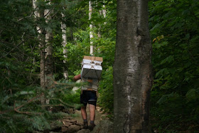
The young folks who are the hosts at the huts are the ones who bring the food up on their backs.  Think about food for 90 guests for dinner and breakfast.  Makes my back hurt.  There are 4-5 hosts at each hut and they make only 2 trips a week for food.  At the beginning of the season, staples are airlifted in, but that still leaves a whole lot of fresh veggies, fruit, and dairy products to be carried in weekly. The tradition is that boys resupplied the hut and these hut boys would compete with each other to see who could carry the most weight.  Today, the hut crews (or croos as they are actually called) are both men and women and the women help with resupply.  For safety reasons, there is also a limit to how much each is allowed to carry.  They still, however, use the traditional pack boards to carry the loads.

Resupplying the hut is a labor of love

The hut croos also provide the nightly entertainment with skits, talks, and/or live music.  The talks and skits are usually geared toward teaching good stewardship of the environment, especially wilderness places like the White Mountains.

Zealand Falls Hut

Our overnight visit was to Zealand Falls Hut.  This hut was built in 1932 and accommodates 36.  Zealand’s feature is the water falls.  Because of the short, easy walk to this hut, many, many hikers come just to spend the day.

 A typical bunk room

Tomorrow, the weather is supposed to be clear.  We may take in Madison Hut.  We’ll see.

Sunday, July 25, 2010

Immersed In Nature


After our long hike yesterday, I wanted something short and easy for today.  I studied the maps and finally found a trail that didn’t go uphill.  It was a very short piece of the AT across the road from Pinkham Notch Visitor Center.  It was most appealing because at the half-mile mark was a pond.  That’s what I wanted--a level trail with a pond.  With rain in the forecast for the afternoon, we headed out right after breakfast.

A beaver dam
The hike was very nice.  There were many photo opportunities along the way and we were able to find a large flat rock which offered the perfect place to sit and enjoy our surroundings.

Lost Pond, the largest pond we saw today
We got one big surprise along the way.  I heard hikers coming up behind me, so I stepped off the trail to let them pass.  When I got situated where I wouldn’t fall, I looked up and low and behold it was Bowtie and Samurai.  We gave these two thru-hikers a ride into Waynesboro when we were there in May.  We had seen them again at Trial Days in Damascus, but that was also in May.  We had a short chat with them, then they continued North on the trail.  They looked good after 1800 miles.  Good luck to them.

View from our perch on the rock

So our day was filled with blessings--the opportunity to enjoy the creation and the opportunity to reunite with old acquaintances.

Saturday, July 24, 2010

Nineteen-Mile Brook Trail


We had a beautiful hike today.  It was a little longer and a lot steeper then yesterday, but we stayed very close to the water almost the entire length of the hike.


Our destination was Carter Notch Hut which is located on Carter Lake.  Actually, Carter Lake is two lakes and the trail passes between them.  The larger lake was covered in yellow pond lilies; the smaller lake had none.


We stopped in the hut and were able to get a cup of coffee to go with our lunch.  On our previous visit to the White Mountains, we hiked to several of the huts.  I’ll dig out those photos and tell the story of the huts in a later posting.  Carter Notch Hut, by the way, was expecting 40 guests for tonight, so we didn’t linger.  The hut crew seemed to be eager to get started with dinner preparations.


I won’t bore you with a lot of words today, but will let the photos tell the story of our hike of Nineteen-Mile Brook Trail.  Enjoy.

Friday, July 23, 2010

Welcome to the North Woods


We went for a wonderful hike today.  It is so different from what we have been doing recently in Connecticut, Pennsylvania, and Virginia.  As Gene says, “Welcome to the North Woods.”


The trail, Amphibrach, started about at a very large parking lot on US 2 about 10 miles west of our campground.  Our first look at the trail was a little intimidating, but that passed quickly and we had a very pleasant hike to Cold Brook Falls and then on to Spur Brook Falls for lunch.  We were able to use a short section of Cliffway Trail to connect with Randolph Path for our return trip.

The blazes are high on the trees

The Amphibrach Trail gets its name from the blaze which marked the trail when it was constructed about 1883.  The blaze actually consisted of 3 blazes, short, long, and short, arranged vertically.  Today it is blazed in the standard 2 X 6 inch blaze in the color yellow.


In less than a mile we came to Cold Brook Falls.  We approached the falls by way of Sylvan Way, however, there is a short spur trail off Amphibrach which approaches the falls from the west side.  We stopped to make a few pictures then proceeded on our way.  We crossed Cold Brook on a very fine foot bridge and started our ascent.  As trails in the White Mountains go, this one was a very moderate climb.  There were short sections that were steep, but generally we could maintain our usual 2-mile per hour.

Bridge over Cold Brook

Well, we could manage 2-miles per hour if I didn’t have to stop so often to take a picture.  Then there was a short side trip over to Cold Ledges and a number of pictures to be made there.

Our lunch spot on Spur Brook

Our destination was Spur Brook Falls for our lunch break. To get to the falls, we needed to turn right onto Cliffway Trail and follow it for about two-tenths of a mile.  We did that and came to Spur Brook, but we didn’t see what we would have called a “falls”.  I went on down the trail for several yards, but the trail seemed to veer off to the left and the brook to the right.  We finally determined we were at the falls, just above it rather than below.  The spot was beautiful, so we found a semi-dry rock to sit on for lunch.

To return to the truck, we backtracked on Cliffway Trail to Amphibrach and continued on Cliffway to Randolph Way.  This short section of Cliffway between the two trails was much less used, but still clear enough to follow.  It was wet, however, and several places were almost boggy.  Reminded me of hiking in the Adirondacks.  I stepped in one spot and sank up to my ankle.  Thank goodness for gore-tex and hightop boots.

As the junction of Randolph Way, we were totally surprised to find a beautiful cascade of Cold Brook and another footbridge on which to cross it.  This would have been a very nice place for lunch, also.  We had a steady downhill hike all the way to the truck.  Again, this trail was moderately graded without too many rocks and roots.

This turned out to be a great hike.  The weather was just about perfect with temperatures in Gorham in the mid 70s.  Even though we did climb too high, we could definitely tell the difference in temperature as we came down.  We had a slight breeze.  There were very few people on the trails.  We had a wonderful day.  Welcome to the North Woods.

Thursday, July 22, 2010

Getting Organized


We had originally hoped to go for a hike today; however, issues with the truck prevented that.  Gene was able to get an appointment at the local Ford dealership for early afternoon.


While waiting for that, we did a major grocery run.  The small IGA in Thomaston just offered enough to get by so I made do with a little from there and what I had in the cupboard.  Today, the cupboard was bare.  We were excited about there being a Shaw supermarket in Gorham, but we quickly learned it has gone out of business.  That left Wal-mart, but that was far better than the little IGA.

I could probably get all worked up into a snit about the truck.  It turns out that the “check engine” light was on because some valve or something was clogged with carbon.  Well, we all know that didn’t get there this past week since our last service appointment.  That’s probably the real reason the check engine light came on in the first place a couple weeks ago.

Now, I’m not saying that the service department in Litchfield did wrong with the other issues.  They took Gene back and showed him the evidence of the leaks they said were there.  I’m just saying I think they should have caught this problem also.

Of course, they weren’t able to fix it today, that will have to wait until Monday.

While Gene was busy with the truck, I sat down with the guidebook and trail maps.  I found several hikes within a short driving distance from the campground; many of which offered ponds, waterfalls, or big views.  I tried to avoid those that used the phrase “steep, rough ascent”.

We have a couple of goals in mind for our hiking.  We primarily want to do some trails that have some kind of feature--pond, waterfall, historic site, etc.  We are ready for relatively short and easy, but that may not always be possible in the Whites.  There are also a couple of peaks we want to climb--Adams, Madison, and Jefferson.  I found a route up Mt Washington that doesn’t look too bad.  We’ll see.  We drove up Mt Washington the last time we were here and Gene says he “ain’t doing that again.”

AMC Visitor Center at Pinkham Notch

After Gene got home from making friends at the Ford place, we drove over to Pinkham Notch to the AMC Visitor Center.  Appalachian Mountain Club maintains many of the trails in the White Mountains, as well as huts, cabins, a couple of lodges, and hiker shuttle buses.  At Pinkham Notch they have a Visitor Center with a small bookstore/gift shop and a snack bar.  We wanted a shuttle bus schedule and a waterproof map for the area where we will be hiking.


We were glad to see the shuttle bus is still in operation, but were dismayed at the high fee--$10 for the shortest ride.  We won’t be doing that very often if at all.

AMC is now printing their waterproof trail maps on Tyvek.  Who would have thought.  Not only is it waterproof and lightweight, but it’ll double as a tarp or ground cover.

Joe Dodge Lodge at Pinkham Notch

For tomorrow, we have selected a short hike which follows a creek gently up the slope past two waterfalls.  We don’t have to race out of the house in the morning.  If we get to the trailhead (which is only about 10 miles west) by midmorning, we’ll have plenty of time to hike to the upper falls for lunch.

We did a little rearranging in our packs also.  The weather is much cooler here and many trails go above timberline which is often very windy.  We each added a hat, gloves, and an extra long-sleeved shirt.  I zipped the legs back on my shorts.  I think we’re ready.  It’s hard to believe I put winter gear in my pack after the sweltering days we had in Pennsylvania and Connecticut.

Hopefully, tomorrow’s journal will have some photos of waterfalls.  Until then..........

Wednesday, July 21, 2010

Settled in Gorham, New Hampshire

We arrived safely about mid-afternoon in Gorham, New Hampshire.  I’d love to say we had a trouble free travel day, but that was not the case today.

We had heavy traffic, especially early this morning as we tried to maneuver through Hartford at the tail end of rush hour.  About the time we saw some relief in the traffic flow we hit Springfield, Massachusetts.  Not a large city as cities go, but everyone seemed to be on the highway.  There was only one lunatic who seemed to think he was driving the Indy 500.  We had a minor heart stopper when he cut in front of us with about 3 inches to spare.

Getting out of the densely populated areas didn’t help much.  Traffic was lighter, but the construction started.  We traveled through one construction zone after another all day long.  In New Hampshire, just when we thought we were home free, we came upon the worst of all the construction zones.  The entire road surface was gone for about a quarter mile.  We thought we were in Alaska again, but without the pilot car.

The real stressor, however, came when the “check engine” light came on again.  Instant panic since we knew it wasn’t the routine reminder for service.  We were only about 4 miles from the next rest area (according to the Next Exit Guide), so the plan was to stop in there and give the dealership in Litchfield a call.  As luck would have it, that rest area was closed.  We drove on to the next rest area and Gene made the call.  He was assured it would be okay to drive it to Gorham since it wasn’t making any horrible noises.  Tomorrow, it’ll be in for service again.  We’re keeping our fingers crossed.

We had a brief moment of comic relief as we were driving east on US 2 just before entering into New Hampshire.  There was some old codger with a pack on his back and a chain in his hand walking along the side of the road.  On the other end of the chain was a huge ball, at least 6 feet in diameter, painted like a globe.  Talk about having the whole world in your hands.  Actually, the old fellow was having some considerable difficulty keeping the world under control.

We were surely glad to arrive at our campground.  We even got set up before the thunderstorm came through.  Life is good, after all.

Tuesday, July 20, 2010

Reflections on our AT Hiking


Well, as you have probably noticed, we haven’t been hiking in the past few days.  Several reasons--primarily the heat, plus I think we just got a little burnt out.  We are going to move from here to Gorham, New Hampshire tomorrow so this seems like a good time to take a few minutes to reflect on the AT hiking adventure so far this summer.

For several years we have wanted to finish the Trail in Virginia.  Seemed like we hiked in Virginia for so long and could never get to the end.  With that goal in mind, we contemplated tentative plans for a summer on the AT.  When all the planning was finished and we were ready to start hiking, we set the goal--hike from Virginia route 614 to the Pennsylvania state line.  That seemed like a good stopping point.

One of the reasons it took us so long to get back to the Trail was sweet Peanut.  I wasn’t willing to leave him in a kennel for an extended time and there was just no one to keep him.  We finally remembered about a couple we had met several years ago who were day hiking and running a shuttle with just one car.  We thought that might work for us and investigated the logistics of a self supported shuttle.

Having done that for two and a half months and almost 400 trail miles, we are here to tell you that we like it.  Of course, there were some trade-offs, but overall, it was a positive experience.  Plus, we exceeded our goal by 37 miles and got a few miles in Connecticut to boot.

For the good things about it:
We didn’t have to carry those heavy backpacks.  Because of what we like to carry on a backpacking trip, it is almost impossible for us to get pack weight below 30 lbs.  With the day packs, even on days when we carried extra water, our packs only weighed about 10 lbs.  That’s a whole lot easier on the back, knees, and feet.

We got to eat real food--breakfast, lunch, and dinner--instead of “trail food”.  We could have fresh vegetables and fruit everyday.  Instead of a granola or power bar for lunch, we often had sandwiches.  Then there was that ice cold cola waiting in the truck every afternoon.

We set a schedule to hike two days and take a day off.  That worked out great.  Sore feet and muscles had a chance to recover before they could develop serious injury.

Perhaps the best part of all was the shower and clean cloths every day.  The laundry basket smelt pretty bad after a couple days, but we didn’t.  Well, at least not too badly.

Of course, there were the parts we didn’t like:
We put a lot of miles on the truck driving back and forth and spent a lot of time on the road.  We were up and out of the house early to try to get to the trail and get most of the miles done before the heat of the day.  When we were dog tired in the afternoon, we had a long drive home.  There were several days when we also scouted out the next parking lot so we could get there quickly the next morning.

I think the worst thing about hiking opposite each other was not getting to hike together.  Generally, I was comfortable hiking alone.  I quickly discovered that I liked hiking southbound rather than north.  By hiking south, I met lots of northbound hikers.  Gene would often not see anyone even though he was surrounded by others.  I enjoyed talking with these hikers and it really made me feel more comfortable knowing they were close at hand.  I think I can honestly say these hikers kept me going.  Even though I knew I was not alone, I still felt a little nervous.  The “what ifs” played heavily on my mind.  What if I fell and broke something; what if I couldn’t cross a stream or get up or down a large boulder; what if I got a snake bite; what if I had a heart attack?  Besides, I missed hiking with Gene.  Part of the fun of the hike is sharing it with someone.

In the plus/minus category was being with the trail community.  We really enjoyed meeting and talking with the thru-hikers.  We had several opportunities to do a little trail magic.  We loved all of that, but because we were just day hikers and didn’t socialize with these folks in the evenings at the shelters, we were really outside the group.

So, overall, we like this method of getting the miles done on the AT.  I don’t think we would do it on any other trail, but to cover the long distances on the AT without having to put Peanut in the kennel, this is a great way to go.

This is getting a little long, so I’ll stop here for today.  Tomorrow, I’ll lay out the plan for the next couple months.  The AT adventure is not over yet.  The best is yet to come.

Monday, July 19, 2010

Western Connecticut


We have been driving around on all the back roads in Western Connecticut for the past two weeks going back and forth to the Trail.  I thought I’d share some of what we’ve been seeing on those drives.


Connecticut is New England and what we have seen is what you would expect to see in New England--green trees which turn to a blaze of color in the fall, old houses, tall church steeples, and village greens. This area is mostly rural farmland with a few dairy farms.


Most of the homes we’ve seen are large, two-story structures.  Whether they are newer or a hundred years old, they’re usually well maintained with nicely manicured yards.  Folks around here like pastel colors for their homes.  We’ve seen just about every color, but yellow and white are the most plentiful.  There are many, many homes with “For Sale” signs out front; an indication of how the economic downturn has hit this state.  We walked by a couple of real estate offices today and glanced at their offerings.  You can get a modest home here for a couple grand, but you’re more likely to pay closer to 5 grand.  We found a small lot in Litchfield without a house for $189,000.  Wonder if zoning regulations would allow an RV pad?

The towns had us confused for a while.  We finally figured out that there is one community which is what we would call the county seat in the south.  It’s the one with the Town Hall.  Smaller villages surround the “town” even though they may be several miles apart.  The smaller villages have their own names, but are encompassed within the larger community.  Most communities have a village green, most with bandshells, but not all.  These small towns and villages are the quintessential quaint New England with pots of fresh flowers sitting on the sidewalks in front of trendy boutiques, art galleries, and antique stores.


It wouldn’t be New England without the tall church spires rising against the trees and blue sky.  We stopped to make photos of our favorite--The Congregational Church in Warren.  Warren is so small, I think it only has a church, the town hall, and a general store.  But this church with its magnificent steeple was there.


This part of Connecticut was settled in the first half of the 1700s.  People have been dying here for a very long time and the cemeteries are plentiful.  We chose to stop at the one in New Milford.  In Tennessee, if you see a flag by an old tombstone, it usually means the deceased was a Civil War veteran.  At New Milford, we found flags at the graves of Revolutionary War Veterans.


We also stopped by Kent Falls State Park today.  The falls, really a cascade, was pitiful.  However, it has been very dry here for several weeks.  In addition to very little rain, in the summer months, water from many creeks and rivers are diverted for use in homes and businesses. The time to see the falls in Connecticut is in spring.


There was a covered bridge at Kent State Park, but I think it was built as part of the walkway to the falls.  It looked just too new and it had no historical marker.  There are covered bridges in Connecticut, but not nearly the number that are in Vermont.

Western Connecticut is pretty.  Enjoy the photos.